Black Butte Loop


")


Caution! We do not provide turn-by-turn directions in our GPX files. Those are auto-generated by your bike computer and are usually less than 70% accurate. Learn more.
For help loading a GPX file onto your bike computer, go here.
DownloadHighlights & Remarkable Spots
Town of Sisters / Beginning and End of Ride
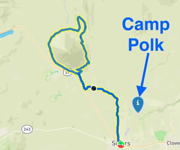
Before Sisters was Camp Polk, a short-lived military camp on the Whychus Creek. The camp was established in September 1865, a time when there was conflict between settlers and Native Americans. The camp was named after the troops it housed – a captain and 42 soldiers, most who were from Polk County. The troops were ordered to protect settlers and commerce traveling the Santiam Wagon Road. There were no attacks, however, and the camp was abandoned in May 1866. Part of Camp Polk is preserved by the Deschutes Basin Land Trust as the Camp Polk Meadow Preserve. [Wikipedia and Deschutes Land Trust]
Black Butte / ~ Miles 9.0 - 24.0

Listed on the National Historic Lookout Register, Black Butte is the site of several generations of fire lookouts that have played a key role in protecting Central Oregon forests for more than a century.
“Black Butte’s long history began in 1910 with a tree crow’s nest tower and tent. About 1923 a D-6 cupola cabin was added, but due to its limited visibility, the crow’s nest must still have been used. An 82′ treated timber tower with 8×8′ cab was constructed in 1934. In 1980, a log cabin was built for new living quarters. The 82′ tower was condemned in the 1990’s, with a replacement 65′ treated timber tower with 10×10′ cab built in 1995. All structures remained on the summit, making this one of the most unique on-site historic collections of lookouts anywhere. In December 2001, the condemned 1934 tower fell down under heavy snow. In 2014, the log cabin was condemned and subsequently burned in November 2016. A yurt is currently used for sleeping quarters. The cupola cabin is currently being restored.” [Fire Lookout]
Viewpoints of Cascade Mountains / ~ Mile 13.0
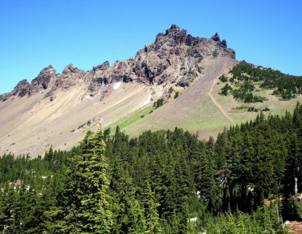
Three Fingered Jack is one of the featured peaks visible from the route. Standing at a tall 7,841 feet, Three Fingered Jack is one of the oldest volcanoes in the Cascade Range. The volcano is extinct, with its last eruption taking place about 250,000 years ago. The volcano was first summited in 1923. It continues to attract climbers, though the rock is of poor quality and reportedly vibrates at the summit during high winds. Originally named Mount Marion, the name was changed to Three Fingered Jack after a Spanish outlaw named Tres Dedos (“three fingers”) who was killed by California Rangers in 1853. [All Bend Oregon]
Metolius-Windigo Trail / ~ Miles 19.5 to 24.0
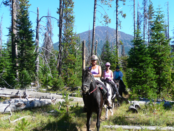
Roughly 4.5 miles of the route parallels the Metolius-Windigo Trail. This trail, which extends 150 miles from the Metolius Basin to Windigo Pass, connects at both ends to the Pacific Crest Trail. Though popular with hikers and bikers, the Metolius-Windigo was built primarily for horse riding as a lower-elevation alternative to the Pacific Crest Trail. [Equitrekking]
When We Like to Ride This
We love to ride this route in the late spring, when the mountains are still snow-covered and the flowers are in bloom. Another great time to ride the route is in the fall, when the leaves are changing colors and there is early snow on the mountains. The route can get soft in the summer, especially on the sections of the trail that are shared with horses.
Terrain & Riding
Overall, this route has moderate climbing and terrain that won’t beat you up too much.
From the start of the route at the Village Green City Park, take a few city streets to get to the Sisters Tie Trailhead at mile 1. The next 7 miles are some of the best riding drop-bar single-track in Central Oregon. They are fast and flat, winding around big Ponderosa trees and paralleling small creeks and marshes.
If the single-track at the beginning of this ride is some of the best in Central Oregon, then the next seven miles along the west side of Black Butte are some of the best double-track in Central Oregon. This section undulates up and down with broken views of the Cascade Mountain through the tall trees. From south to north, you’ll see Three Sisters, Mt Washington, Three Fingered Jack, and Mt Jefferson.
The next 4 miles are the only miles of proper gravel road. The first three are red cinder, climbing 600 feet with an average gradient of 4%. Mile 4 and a bit are a gray gravel road that sees enough traffic to develop some annoying washboard. Have no fear, as the road ripples are short-lived.
At mile 18.6, turn right turn into a dirt parking area with a trail kiosk. Continue straight and pick up the double-track, which is the Butte Loop Trail around the east side of Black Butte. It has seen some recent trail work, but not a lot of riding. We would call this a gem.
The next 6 miles are the most technical of the day. In places a bit more chunky and a bit more steep. But, overall the technical demand is not beyond that of a intermediate gravel rider. We thought the riding was terrific, especially with the pop-up mountain views.
Roll back into Indian Ford Campground on some finishing double-track and then pick up the stick of the lollipop back to Sisters on the 7 miles of sweet Sisters single-track. Along the way, give a big shout-out to the Sisters Trail Alliance for making this route possible.
The Start
The route begins at the Village Green City Park in downtown Sisters. The park offers flush toilets, showers, and water. No fees or permits are required to park.
Food & Water
- None.
Route Notes
Sections of the route are shared with horses. Pass with care. Stop if necessary, ask the rider for the best way to pass, and continue to speak to the horse and person as you pass.
Get Involved!
 The great single-track trails on this route were developed and are maintained by the Sisters Trail Alliance. If you like what they have done, please consider making a contribution to their campaign so that they can continue with the great work!
Videos
The Ride! Black Butte Loop
A quick 2-minute video of what to expect on your ride!
Traveling Back in Time at the Camp Polk Cemetery
Although not associated with Camp Polk, the cemetery that bears its name holds a rich and unique history. Established in 1880 as a final resting place for early settlers, the cemetery enables visitors to travel back in time.
Ridden and Reviewed by:


 Behind every route is scouting, mapping, storytelling, and a whole lot of pedal power.
Have you ridden this route? Got a question? Join the discussion!