7 Mile Hill


Caution! We do not provide turn-by-turn directions in our GPX files. Those are auto-generated by your bike computer and are usually less than 70% accurate. Learn more.
For help loading a GPX file onto your bike computer, go here.
DownloadHighlights & Remarkable Spots
Historic Columbia River Highway State Trail / ~ Miles 1 to 6

About a mile in, you will reach the Historic Columbia River Highway State Trail which is a scenic, paved path along stretches of the old historic Highway 30, which predated I-84 as the only road connecting Portland and The Dalles.The highway was built between 1913 and 1922 and was the first planned scenic roadway in the United States. [Oregon State Parks, Wikipedia]
Mosier Twin Tunnels / ~ Mile 4.8
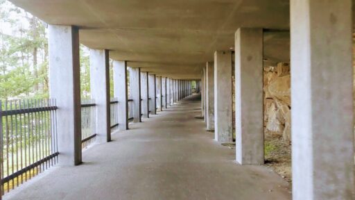
Tunnels back to back! The Mosier Twin Tunnels are car-free and features spectacular views of Hood River (not to mention how cool it is to ride through the tunnels.)
Mosier / ~ Mile 6
At mile 6, you will pass through a little town call Mosier. Mosier’s white settler history dates to 1854, when Jonah H. Mosier (1821-1894) built a series of sawmills at the mouth of Mosier Creek. During the late nineteenth century, Mosier had a railroad station and was a steamboat landing for boats headed upriver.[Oregon Encyclopedia]
Rowena Crest Viewpoint / ~ Mile 13
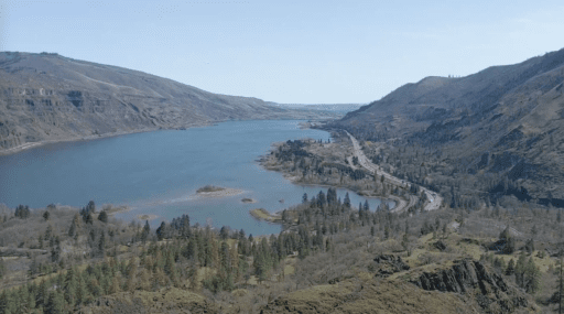
If there was one viewpoint to capture the gorge, the Rowen Crest Viewpoint seems to show a little bit of everything from the Columbia River to passing trains to the gorge bluffs and panoramic views. This viewpoint was obtained as a gift from Mark Mayer in 1924. [National Park Service] Looking down from this viewpoint you can see the historic highway that continues and creates a “U” shape as it winds down as it just entices you to ride!
The Dalles / ~ Mile 21.3
The Dalles is one of the oldest permanently occupied places in Oregon, significant to Native people for over ten millennia and to Euro-American settlers since the 1830s. Native people gathered on the banks of the Columbia River to fish and trade. During the summer and fall fish seasons, the population of the area swelled dramatically as people from other bands gathered there for trade and interaction. For white settlers, The Dalles was the jumping-off spot for pioneers, soldiers, gold miners, and adventurers.
The word dalles was commonly used by fur traders to refer to areas where a river flows through narrow, rocky channels, and French Canadian fur traders of the Hudson’s Bay Company called the great rapids at The Dalles Les Grandes Dalles de la Columbia. Fur trader Gabriel Franchère described the rapids in 1814 as “a channel cut by nature through the rocks, which are here almost perpendicular: the channel is from 150 to 300 feet wide, and about two miles long. The whole body of the river rushes through it, with great violence, and renders navigation impracticable.” [Oregon Encyclopedia]
When We Like to Ride This
Spring through Fall is a good time to ride this route as there can be slick areas or snow at higher elevations in the winter. Be advised if it is a windy day, the course rides better in the opposite direction. It is much easier to descend 7-mile hill in the wind than to climb it in the wind.
Terrain & Riding
This route starts in town and then winds up to the Historic Columbia River Highway State Trail, which has gobstopping views of the Columbia Gorge …. take the extra min to turn out to the viewpoints. The route includes a tunnel perfect for cyclists (which is not a tunnel that should require a light. It’s short enough you can see from one end to another.).
Look out for the walkers with dogs and kids on banana seat bikes, which is all code for “slow the heck down.”
At just past mile 6 you come to Mosier which is a touristy place hidden among the fruit orchards. Then climb 750 feet up to a sign that says viewpoint which is well with the short detour to enjoy another view of the Colombia River and to salivate over the upcoming Rowena curves, a lovely downhill that will leave you with a shit eating grin.
Now enjoy the curves …
When you reach the Dalles, check your water .. and wipe off that grin at the gas station because soon enough you are on a road called “7 Mile Hill Road” … it’s a treeless road that switches up and up and up again. (We were on this road when it was 99.9 degrees which is a tremendous way to drop five pounds.). E-v-e-n-t-u-a-l-l-y you will see the iconic Mt Hood … and then the top.
Now before you think we forgot to include gravel on this ride, you crest the top and then take a left onto Dry Creek Road. It’s a wide gravel road with lovely views of the surrounding valleys. It takes you straight back down to Mosier where you hop back on the Historic Highway 30. The gravel is fast and easy.
From Mosier to the tunnel is called the forgotten climb — on the way out you were so distracted by lovely views you didn’t quite notice that descent. After the climb, you roll along … until you are rewarded for all your efforts with sweeping downhill turns that pop you back into Hood River.
After all that fun on the bike, you might just head down to the riverfront to see all those crazy water sports.
The Start
The Park and Ride at junction of Highway 35 and Old Highway 30.
Food & Water
- ~ Mile 6.5 and 34.5: Mosier General Store
- ~ Mile 21: The Dalles
Route Notes
A great entry level intermediate ride, not too long, not too steep, not too technical.
We recommend a red blinky light with rear looking radar detector.
Route Options
Some people prefer to do the route in the opposite direction of that mapped here, especially on a windy day. Climb the gravel, descend the pavement.
If the Park and Ride is full, just drive up the route and you will find another parking area just around the corner (a pull out area).
Love Where You Ride! Learn More
The first and last 6 miles of this route are along the Historic Columbia River Highway State Trail. This is a fantastic example of Oregon State Parks providing great recreational opportunities.
Videos
The Ride! 7 Mile Hill
A quick 2-minute video of what to expect on your ride!
Keep it Local! Learn More
Ridden and Reviewed by:


 Behind every route is scouting, mapping, storytelling, and a whole lot of pedal power.
Have you ridden this route? Got a question? Join the discussion!