Tour of the Brobdingnagians


Caution! We do not provide turn-by-turn directions in our GPX files. Those are auto-generated by your bike computer and are usually less than 70% accurate. Learn more.
For help loading a GPX file onto your bike computer, go here.
DownloadHighlights & Remarkable Spots
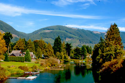
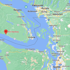
Port Renfrew / Beginning and End of Ride
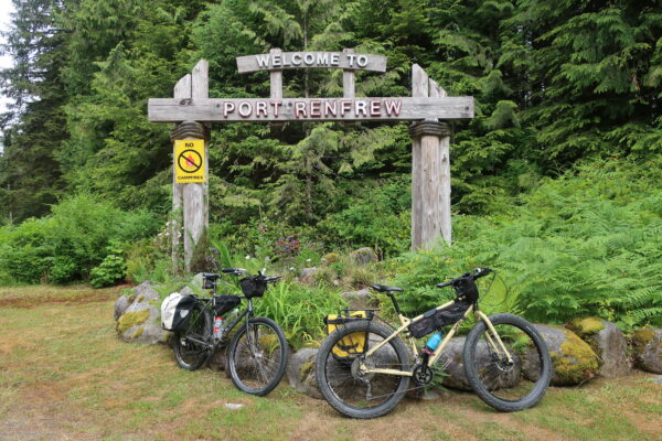
The town of Port Renfrew, native land of the Pachedaaht First Nations, was once a thriving logging community. When conservation efforts began focusing attention on the incredible old-growth forests in the area, the town’s focus shifted from logging to ecotourism. Port Renfrew has attracted an increasing number of tourists who wish to see the largest and oldest trees in what is now known as the “Tall Tree Capital of Canada.” With all the changes, the community has realized that revenue from tourism surpasses that from logging. [Ancient Forest Alliance]
Red Creek Fir / ~ Mile 16.5
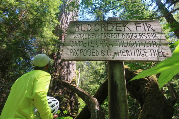
The Red Creek Fir is the world’s largest Douglas fir by volume. It is located in the shaded, southern slopes of the San Juan Valley, just a few valleys east of Big Lonely Doug. The Red Creek Fir stands more than 242 feet tall (73.8 meters). It has a circumference of more than 32 feet (9.8 meters) and measures nearly 14 feet (4.2 meters) in diameter. The tree was seeded approximately 1000 years ago. [Wikipedia]
San Juan Spruce / ~ Mile 23.0
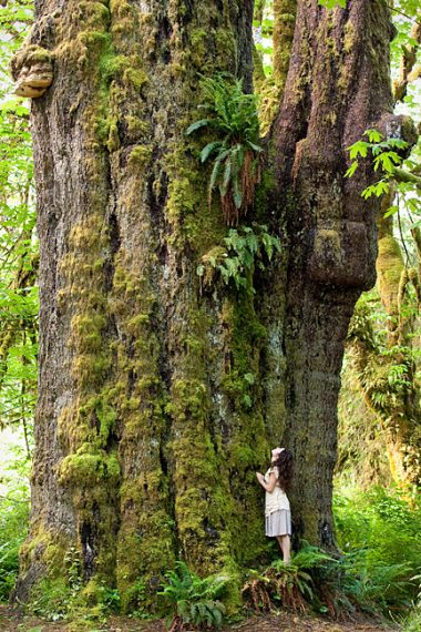
Until 2016, the San Juan Spruce was the world’s second largest Sitka by volume, surpassed only by the Queets Spruce in Washington. In 2016, the tree lost significant height and mass due to a lightning storm. Though it is no longer considered to be among the world’s largest San Juan Spruces, its diameter is still significant. [Wikipedia]
Photo Credit: TJ Watt
Harris Creek Spruce / ~ Mile 32.5
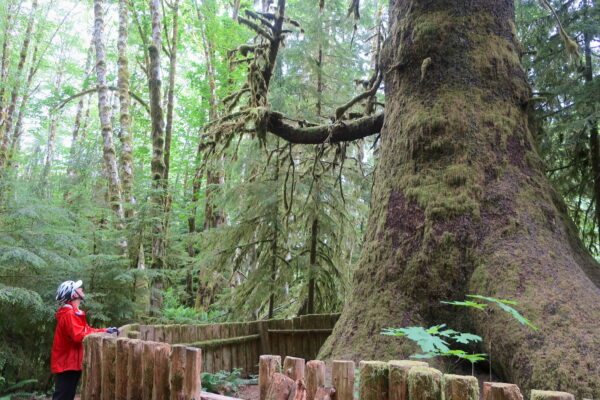
The Harris Creek Spruce is a large Stika spruce located off the Pacific Marine Road near the creek bed of Harris Creek. Although it is not the largest Sitka spruce on Vancouver Island, it is the largest spruce that is easily accessible. The Harris Creek Spruce stands approximately 260 feet tall (80 meters) and has a diameter measuring approximately 13 feet (4 meters). When the original old-growth forest was first logged in the 1893, the Harris Creek Spruce was saved. It now stands in a second-growth forest. The tree is surrounded by a fence to protect its root system from trampling. The tree is protected by a 2012 vote that permanently restricted logging in this area. [Wikipedia]
Walter Van Hell, Dennis Cronin’s colleague, helped to promote the formal protection of this tree.
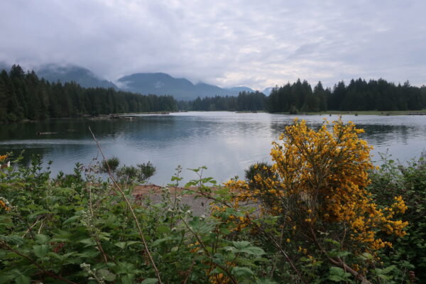
Lake Cowichan / ~ Mile 49.0
The town of Lake Cowichan, which offers a full range of services, is off-route by ~4.5 miles. “The town was not only located in the heart of southern Vancouver Island’s forested hills but for decades had been one of the region’s most important timber hubs.” [Big Lonely Doug]
Lake Cowichan is one of the largest fresh-water lakes on Vancouver Island. Between 1913 and 2001, three big lumber mills dotted the shores of Lake Cowichan and nearby Lake Mesachie in the communities of Honeymoon Bay, Mesachie Lake, and Youbou. [Lake Cowichan Gazette]
Honeymoon Bay / ~ Mile 51.0
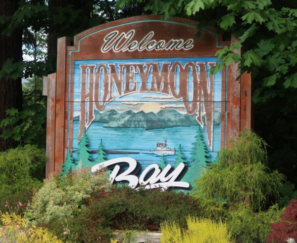
Honeymoon Bay, off-route by ~0.5 miles, is a small unincorporated community. The town has a small market.
In 1946, the newly established Western Forest Industries invested one million dollars to grow the community of Honeymoon Bay. To attract married workers and their families, new homes were constructed. A company store, post office, gas station, church, and park provided amenities for the residents. The mill was closed and demolished in 1981. The community suffered for nearly a decade but was rediscovered in the 1990s. The small town is now flourishing. [Victoria Freenet Association]
Big Lonely Doug / ~ Mile 75.5
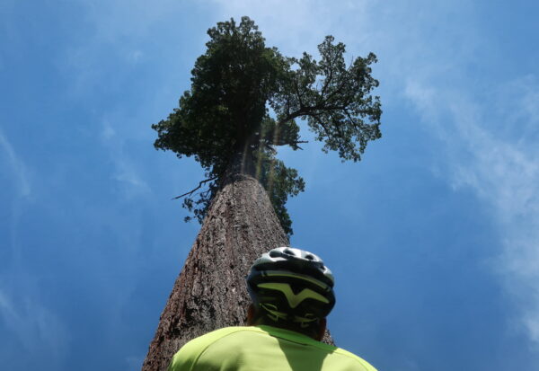
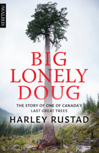
Located in the Gordon River Valley, Big Lonely Doug is the second largest Douglas fir by volume in Canada. Big Lonely Doug stands more than 230 feet tall (70.2 meters). It has a circumference of more than 39 feet (11.9 meters) and measures nearly 13 feet (3.9 meters) in diameter. The tree was seeded approximately 1000 years ago. In 2011, logger Dennis Cronin discovered the tree while surveying land to be logged and wrapped a green ribbon around the tree with the words “Leave Tree.” In 2014, photographer and activist T.J. Watt happened upon the tree and named it “Big Lonely Doug.” The tree has become a symbol of conservation in Canada and is featured in the 2018 book Big Lonely Doug: The Story of One of Canada’s Last Great Trees by Harley Rustad. The tree has been designated for protection by the Government of British Columbia. [Wikipedia]
Eden Grove / ~ Mile 76.0
Eden Grove, adjacent to cutblock 7190, is located on Edinburgh Mountain in the Gordon River Valley. The grove was named by Ken Wu and TJ Watt of the Ancient Forest Alliance, as it reminded them of the Garden of Eden. The grove includes approximately 30 hectares of prime valley bottom ancient forest, including Douglas fir and Western red cedar. Many of the grove’s trees are 500 to 1000 years old. [BC Tree Hunter]
Avatar Grove / ~ Mile 80.0
The Avatar Grove is located just to the north of Port Renfrew. The Avatar Grove is home to many impressive old-growth trees, including “Canada’s Gnarliest Tree.” In late 2009, the Ancient Forest Alliance identified the grove and began a 2-year campaign to protect the trees. Thousands of people supported the campaign, as well as the Port Renfrew Chamber of Commerce and business community. In February 2012, Avatar Grove was declared off-limits to logging. [Ancient Forest Alliance]
According to the Ancient Forest Alliance, Avatar Grove is “the most accessible and finest stand of ancient trees left in a wilderness setting on the South Island.” [Big Lonely Doug]
Gordon River Estuary / ~ Mile 84.5
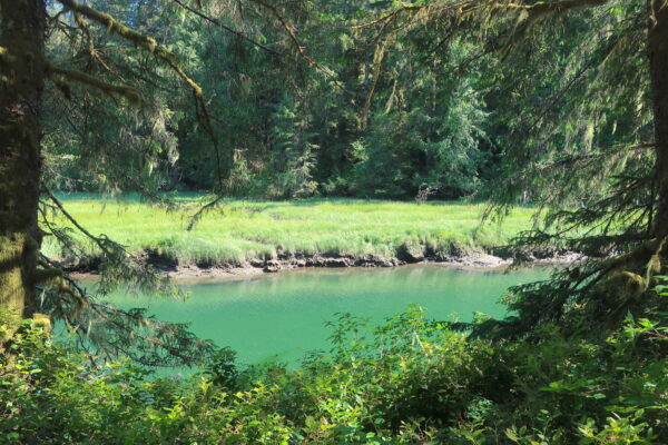
Two projects to improve the habitat of the T1′ oqwxwat’ Estuary (Gordon River Estuary) were completed by the Pacheedaht First Nation in 2020 with funding from the Government of Canada’s Coastal Restoration Fund. The first project involved removing a dike and restoring the pond behind the dike to salt marsh habitat. This project doubles the amount of salt marsh rearing habitat for salmon. The second project involved excavating breaches to reconnect historic tide channels between the existing salt marsh and Brown’s Slough. This project provides fry from the Gordon River with access to rearing habitat in the slough as well as the salt marsh. [Signs posted around Port Renfrew and Fisheries and Oceans Canada]
San Juan River / ~ Mile 86.0
The San Juan River supports six species of salmon: Chinook, Chum, Coho, Pink, Sockeye, and Steelhead. These salmon provide food for the Pacheedaht First Nation as well as catches for recreational fishermen. The area has undergone a four-year stabilization project to add a gravel bar of nearly 120,000 square meters. This bar has been planted with young conifer and willow stakes. As these plantings grow into shrubs, they will stabilize the gravel bar, allowing for the ecology to recover and a forest to grow. The gravel bars, in turn, will capture and stabilize bedload material that will create deep pool habitats allowing for juvenile and adult salmon to thrive. [Signs posted around Port Renfrew and Fisheries and Oceans Canada]
When We Like to Ride This
The winter months are cold and wet, and you may run into snow at higher elevations. The riding is best June through September when the temps are warmer and the skies are drier.
Terrain & Riding
This route begins on the paved Juan de Fuca Highway (Hwy 14). Though the road does not have heavy traffic, you will certainly encounter automobiles and possibly logging traffic, too. The road is narrow and winding with no shoulder.
Two miles into the ride, turn left onto Red Creek Main to begin the gravel portion of the ride along the San Juan River Estuary Geological Reserve. This route has a variety of gravel surfaces. You’ll see everything from solid gravel to smooth-as-butter hardpack to sections of chunky rocks. Keep your eyes out for potholes, especially those obscured by the shade.
Once you veer left onto Red Creek Main, you will begin descending towards the Red Creek Fir. The road gets rougher the further you descend. Like, really rough. Wide tires and/or suspension will be your friend on this section.
Allow at least 25 minutes to explore the area around the Red Creek Fir.
The path to the San Juan Spruce is easily missed. The path, which is behind a wall of gravel, is immediately across from the yellow “Main 2 km Down” sign. You will see the San Juan Spruce right away. We encourage you to walk to the end of the path, where you will see other large trees. En route, you will see a fun swing, camp spots, and a path leading down to the San Juan River where you can take a refreshing dip. Allow at least 15 minutes to explore the area around the San Juan Spruce.
At the end of Lens Main, rejoin the paved Pacific Marine Road for a smooth ride north towards Lake Cowichan.
The Harris Creek Spruce is right off the main road and right next to Harris Creek. Allow at least 10 minutes to meet the Spruce.
The Harris Creek Viewpoint is definitely worth a stop…and perhaps even a dip in one of its lower pools.
Consider stopping to see the roadside memorial ~ Mile 36.5 before beginning the long climb.
At ~ Mile 49.0, you’ll stop at the one-light intersection on South Shore Road. The route heads west for two miles before turning off onto gravel on Gordon River Road. The turnoff is unsigned but has a single blinking light at its intersection. South Shore Road has a moderate shoulder. The speed limit for vehicles ranges from 50-70 km per hour. You can easily navigate off-route to either Honeymoon Bay or Lake Cowichan for overnight accommodations, food resupplies, or swimming opportunities.
When you are ready to carry on, continue south on Gordon River Road. The gravel is like silk for miles and miles, getting rougher once you pass Gordon River at ~ Mile 62.5.
Shortly after passing the Edinburgh Main Bridge, you will encounter a very steep section of road that has large chunks of rock and deep craters. If you’re hardcore, feel free to ride this section. If you’re sane, get off your bike and hike your bike past this section. The yucky road won’t last for long. Soon you’ll be back in the saddle.
There are three main viewing points to see Big Lonely Doug, and we recommend that you check him out from all three locations: 1) the old logging pad (this is down a short gravel spur to the right before you approach Doug), 2) the road above Doug, and 3) at Doug’s base (follow the steep trail down to the forest floor). Allow at least 30 minutes to meet Big Lonely Doug.
Allow at least 25 minutes to explore Eden Grove.
Allow at least 50 minutes to explore Upper and Lower Avatar Groves.
After you cross the Gordon River Bridge over Baird Creek (~ Mile 81.0), the route will be intermittent pavement and gravel. As you approach the Port Renfrew Marina and RV Park, the route will be entirely paved (~ Mile 83.5) for the remainder of the tour.
The Start
The route begins at the Pacheedaht Gas Bar in Port Renfrew. There is a gas station here, as well as a small convenience store. The Visitors Center, which offers information and WiFi, is located in the back left corner of the property. Ask for permission to park here. You may or may not be granted permission.
If you are staying overnight in Port Renfrew, it would be best to park at your lodge or campground and cycle to the Pacheedaht Gas Bar to begin the route.
Day-use parking is available for $15/day at the Pacheedaht Campground. The campground has two day-use lots – one at the entrance to the campground at the northwest corner of the San Juan Bridge and the other just across from the West Coast Trail Registration office. Pay for the parking at the Pacheedaht Campground Office (305 Pachidah Rd in Port Renfrew). Be aware that the office is not staffed full-time, so you may need to wait an hour or so for staff to appear.
Food & Water
- ~ Start & End / Community of Port Renfrew
- ~ Mile 49.0 / Lake Cowichan is ~4.5 miles off-route to the east
- ~ Mile 51.0 / Honeymoon Bay is less than 0.5 miles off-route to the west
Route Notes
The climate in southwest Vancouver Island is temperate. Temps can be warm or cold and the skies can be dry or wet…all in the course of a single day! Be sure to pack appropriate layers and raingear. Wear visible colors, especially since you are riding a route with logging traffic.
The light on the route can vary from sunny to shady and all hues of filigreed light in-between. Wear bright colors and consider using bike lights. Keep your eyes open for potholes or other obstacles that may be obstructed by the shade.
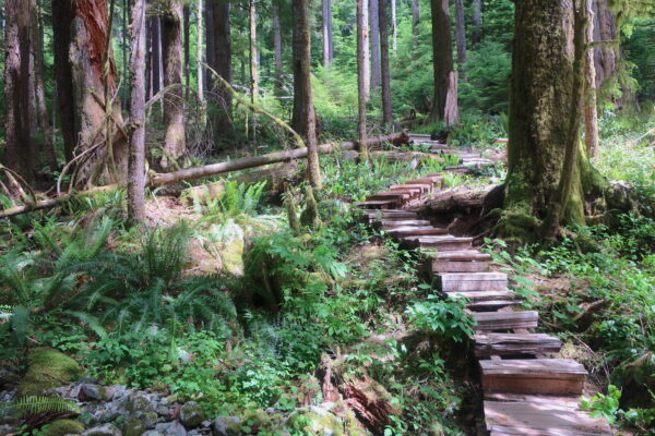
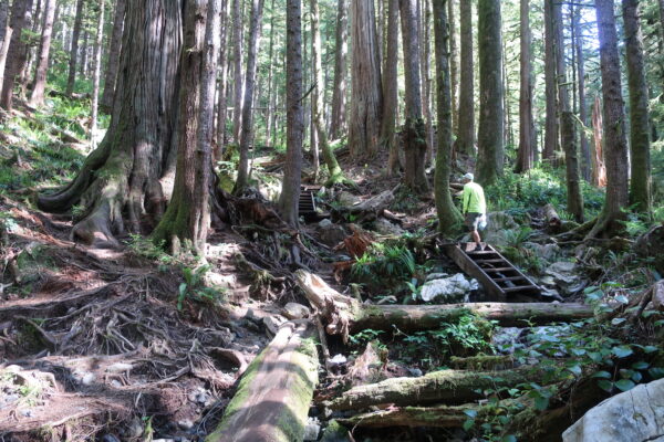
Do not judge your time to ride this route based on the mileage and elevation alone. Allow plenty of time to get off your bike to walk around and meet the trees. Make sure to wear comfortable shoes for walking. Be mindful not to tread on the roots of the big trees. Also, keep in mind that it is very easy to get turned around in the forests. Consider tracking your location with your phone or device as you walk the forests so that you can find your way back to your bike.
This route can be ridden in 1-3 days. Hammerheads may choose to ride the route in one day, but they will have little time to meet the trees. Two days is doable, though cyclists will need to stay on a schedule to both meet the big trees and complete the route in time. Three days is most desirable, as cyclists can take their time to enjoy the route and have ample time to explore the big trees.
This loop can be ridden as a multi-day tour with a self-contained set-up. There are multiple camp spots along the route – some are marked on the route, but many are not. Some of the route passes through private timberland where “stealth camping” is not permitted (as indicated on the map). In these areas, you must camp in a designated campground. The loop can also be ridden as a “credit card tour.” Indoor lodging is available in Port Renfrew, Lake Cowichan, and Honeymoon Bay. Make reservations far in advance. Food is also available in these locations.
Black bears live in the forests of Vancouver Island. Though the bears in the southern part of the island tend to be skittish, be bear-wise and consider carrying bear deterrent with you.
Most of the bridges in the area are narrow and can only accommodate one-way traffic. Slow your speed as you approach all bridges, and be mindful of the signs indicating to yield to oncoming traffic. As you cross the bridges, consider peeking over the sides, as some bridges cross creeks with dramatic canyon walls, waterfalls, and/or pools. Perhaps one of these creeks will entice you for a mid-ride swim!
You will not be able to ride your bicycle along any of the trails to see the big trees or groves. You may be able to find a place to lock up your bicycle, but keep in mind that many of the trees in the forests are too girthy for a bike lock. Consider stashing your bicycle in a not-so-obvious place near the trailhead.
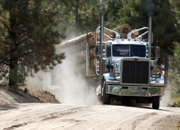
There is active logging along this route. Consider riding this route on the weekends to avoid logging traffic. It is fine to ride during the week, just be aware of logging trucks. If you hear a truck approaching, pull clear off to the side of the road and wait for the truck to pass. Keep in mind that these trucks will likely kick up dirt, which will obscure the road until the dust settles. A respectful friendly wave and a smile will get you far, as the logging trucks are more likely to radio to other drivers to let them know there are cyclists in the area. For more information on riding BC logging roads see our resource page (a highly recommended read!).
Sections along the route are steep and rocky and may require a hike-a-bike, though none of these sections lasts for long.
There are plenty of creeks and rivers along the route for filtering water.
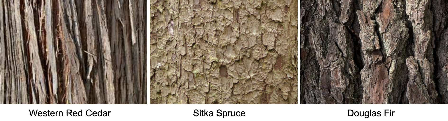
You’ll get far more bang for your buck on this tour if you learn to identify Western Red Cedars, Sitka Spruces, and Douglas Firs. We recommend you learn to recognize the barks of these trees, as the needles for these giants will be too hard to see. Cedar bark is linear, spruce bark is scaled, and fir bark is cracked.
There is a sign posted outside Avatar Grove that reads: “ATTENTION: Avatar Grove Recreation Site – Temporary Closure for Public Safety and Environmental Protection Concerns. Effective: January 20, 2022. For updates see Recreation Sites and Trails BC.
We’d like to get a more accurate read on the elevation gain for this route. After you’ve ridden this route, leave us a note in the Comments telling us the gain according to your device.
Route Options
If you wish to make this route (slightly) shorter and (considerably) easier, consider taking Deering Road north from the Pacheedaht Gas Bar and then turning right onto the paved Pacific Marine Road east to join with the route ~ Mile 25.5. If you do this, we recommend you consider riding the Big & Small Trees Loop as a separate ride so you can still meet the Red Creek Fir and the San Juan Spruce.
Dirty Freehub's READ & RIDE Program
 It’s one thing to see massive trees in an old-growth forest as you cycle along beautiful gravel roads. It’s another thing to understand the significance, history, and impact of the trees. This route is part of Dirty Freehub’s READ & RIDE program. READ to learn about the old-growth trees on southwest Vancouver Island. Then RIDE to meet the trees in-person. Click here to learn more.
Videos
Giant Tree Hunters
Big tree photographer and wilderness explorer, TJ Watt, searches to find the biggest tree in Canada in the rainforests on southern Vancouver Island. In Port Renfrew, he's joined by two big tree climbers in an attempt to break a world record.
Climbing Big Lonely Doug
Watch climbers ascend Big Lonely Doug.
Podcasts
Big Lonely Doug
Ever visited a location from your favorite book? Cool, right? Dirty Freehub’s new READ & RIDE allows you to do just that! READ & RIDE matches 5-star gravel routes with books to create a memorable journey. Read to learn, then ride to bring the pages to life! No worries if books [...]
Tree Conservation Through Photography with TJ Watt
Meet TJ Watt, Big Tree Hunter, co-founder of the Ancient Forest Alliance and an award-winning nature and conservation photographer from British Columbia whose images have helped bolster campaigns to secure the protection of important environmental areas.
In this episode, TJ explains [...]
Saving Old Growth Trees with Ken Wu
Ken Wu, former Executive Director and Co-Founder of the Ancient Forest Alliance, has spent years protecting ancient forests in British Columbia. A major player in protecting Big Lonely Doug, Ken tells how he named the iconic Doug Fir. He also talks about how the indigenous people of Canada [...]
Big Lonely Doug with Author Harley Rustad
Meet Harley Rustad, author of Big Lonely Doug: The Story of One of Canada’s Last Great Trees. In this episode, Dirty Freehub’s Sarah Burch interviews Harley about his book for the READ & RIDE program. Learn what inspired Harley to write Big Lonely Doug, how his book has [...]
Be Informed!
Keep it Local! Learn More
Ridden and Reviewed by:

 Behind every route is scouting, mapping, storytelling, and a whole lot of pedal power.
Have you ridden this route? Got a question? Join the discussion!