To the Wall


Caution! We do not provide turn-by-turn directions in our GPX files. Those are auto-generated by your bike computer and are usually less than 70% accurate. Learn more.
For help loading a GPX file onto your bike computer, go here.
DownloadHighlights & Remarkable Spots
Atascosa Mountain / ~ Mile 5
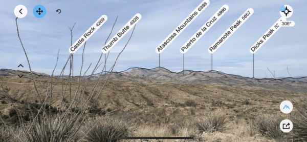
This route is centered in the Pajarito mountains.
“The Pajarito Mountains are a small mountain range of western Santa Cruz County, Arizona, United States, that extend south into Sonora, Mexico. The range is adjacent to the Atascosa Mountains to the north, with both ranges in the center of a north-south sequence of ranges, called the Tumacacori Highlands.” [Wikipedia]
“Although unimposing in elevation, the Tumacacori Highlands have sharp ridges, steep slopes, and rocky cliffs that limit the number of roads and give the area a feeling of remoteness. The vegetation is scattered evergreen oak woodlands on north-facing slopes with scrub-grasslands on south-facing slopes. Mesquite and acacia shrubs are common, as are agaves and sotols.” [US Forest Service]
The Wall (first views) / ~ miles 8 to 10
This road was built and used for the border wall construction from 2016 to 2020. It is hard-packed with a base of crushed gravel. The road is still actively being used for transport (i.e. be alert for heavy-duty trucks).
At mile 8.4, you get your first view of the border wall in the distance. The best border wall viewpoint is at mile 9.9.
Mount Wrightson, Mount Hopkins, Elephant Head / ~ Mile 16.6

At ~ mile 16.6 in the distance are the Santa Rita Mountains with Mount Wrightson, Mount Hopkins, and Elephant Head.
“The highest point in the Santa Rita range, and the highest point in the Tucson area, is Mount Wrightson, with an elevation of 9,453 feet (2,881 m). The range contains Madera Canyon, one of the world’s premier birding areas. The Smithsonian Institution‘s Fred Lawrence Whipple Observatory is located on Mount Hopkins. The range is one of the Madrean sky islands.”[Wikepedia]
The Wall Viewpoint / ~ Mile 19
At mile 19, you can take the little right-hand turn to a close-in viewpoint for the wall.
Credits & Acknowledgements
TimothyS of Tucson first turned us onto this area. A big thank you to him!
Ridden and Reviewed by: Kevin English and Linda English of Team Dirty Freehub.
When We Like to Ride This
Fall through spring. Summer could be hot and exposed. Note, in spring the creeks / washes may hold water.
Terrain & Riding
Like the Patagonia area (to the east by ~ 30 miles), this route is composed of rolling hills, steep pitches, several views of the distant mountain ranges, and an up-close view of the border wall. You will battle pitches up and down of 15% but they are not extremely long (a half-mile or less each).
The route never has a continuous straight-up climb but there is one longer descent that is more continuous. There are two flatter sections (not really evident on the elevation profile, ~ miles 14 to 16, and ~ mile 23 to 26) with green grasses, tightly clustered trees, and desert scrub that make for a really nice texture change.
The road, for the most part, are hard-packed gravel. Mile 23 to 23.4 you’re in a wash. At ~ mile 25.5, you are on the backside of the urban for a short bit.
At about mile 26, you start a short sector of double track. For the most part, it is rutted, pitchy, rocky, and the most technical of the day. At mile 28.3 it’s back onto a nice gravel road. However, it is all rideable by a skilled rider.
The Start
A makeshift dirt parking area off of the west side of Old Ruby Road.
Food & Water
- None.
Route Notes
We rode this on Salsa Cutthroat adventure bikes with Rene Herse Fleecer Ridge 2.2″ tires.
Route Options
The rugged / primitive section can be avoided by taking the dirt bail-out road to the right at mile 25.4. Continue straight until intersecting the frontage road along Interstate I-10. Go north, 2.3 miles until intersecting Old Ruby Road. Go left and rejoin the original course.
RideWithGPS: Alternative Route
Get Involved!
Unfortunately, the border wall has a significant impact on wildlife. To learn more we encourage you to read this quick synopsis from Stanford Earth Matters magazine.
One way you can make a difference is by volunteering or donating to an organization that works to protect and preserve wildlife habitats. An organization that we think does great work is The Nature Conservancy![]() .
.
Videos
The Ride! To the Wall
A quick 2-minute video of what to expect on your ride!
Podcasts
Abandoned Construction Sites Scar Landscape Around U.S.-Mexico Border
We have included this podcast to explain why there are gaps in the border wall, not to make any sort of political statement.

 Behind every route is scouting, mapping, storytelling, and a whole lot of pedal power.
Have you ridden this route? Got a question? Join the discussion!