Silver Onion


Caution! We do not provide turn-by-turn directions in our GPX files. Those are auto-generated by your bike computer and are usually less than 70% accurate. Learn more.
For help loading a GPX file onto your bike computer, go here.
DownloadHighlights & Remarkable Spots
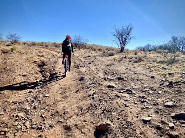
Pinery Canyon Climb / Gravel / ~ Miles 0 to 8
In the first 8 miles, you will gain approximately 2100 feet. The first 3 miles are uphill, but only at 2 to 3%; a good chance to warm up the legs. Just after the turn for Pine Canyon, FR 42C, the road kicks up.(Micro-video) From here to Onion Saddle at mile 8, the grade is 6 to 8% with a few breaks. The road twists and winds uphill through the Coronado National Forest / Chiricahua Mountains like a good European road climb. Initially, the riding is in the forest of pine and oak trees, but as you climb higher the views open up.
In 2011 the Horseshoe 2 fire swept through this unique and highly important ecosystem. The area between 4800 feet and 8900[USGS] feet is classified as part of the Madrean Sky Islands Pine-Oak Woodlands.
The Madrean pine-oak woodland is one of 34 regional hotspots worldwide where 75 percent of the planet’s most threatened mammals, birds, and amphibians survive. Hotspot habitat originally covered 15.7 percent of the Earth’s surface but is at just 2.3 percent today. The Madrean pine-oak woodlands are only 1 of 2 hotspots in the United States. [EurekAlert]
The Madrean Sky Islands contain some of the most rugged and remote lands in the southwest and feature some of the world’s highest levels of biodiversity. More than 7,000 species of plants and animals–including over half of the birds in North America–can be found here. The 143 mile (230km) stretch of the San Pedro River alone contains more native vertebrate species than Yellowstone National Park. [Sky Island Alliance]
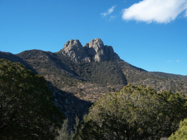
At ~ mile 7 as you make a sweeping bend to the left. In the far distance is Dos Cabezas Peaks (Two Heads). They lie to the northwest of you by about 30 miles at an elevation of 8357 feet.
Paradise Township / Gravel / ~ Miles 8 to 20
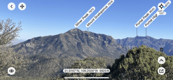
The next 12 miles drop 3000 feet of elevation with three distinct sections. The first, from Onion Pass until the junction with Forest Road 42B, the road twists and turns, contouring lower with sweeping views to the northeast of cliff bands and peaks.(Micro-video) Silver Peak is the most prominent mountain. In the far distance is the San Simon Valley, the Peloncillo Mountains, and New Mexico.
The next section of riding [miles 11 to 15] is the most rugged of the day, from the left turn onto Forest Road 42B to the “ghost town” of Paradise. The pitches will range from 4 to 10%, but as you get closer to Paradise, the grade eases up. You drop through pine-oak woodlands(Micro-video) into the desert hills with a mix of trees, cactus, and other desert plants. Paradise is marked by a few houses, but there are no services.
Paradise is a ghost town in Cochise County in the U.S. state of Arizona. The town was settled in 1901 in what was then the Arizona Territory. The Chiricahua Development Company located a vein of ore here. A post office was established on October 23, 1901, and at its peak, the town had saloons, general stores, a jail, and a hotel. The town was essentially abandoned when the local mines failed, and the post office closed on September 30, 1943. However, a few residents remained. In June 2011, there were five permanent residents and 29 standing structures when the Horseshoe 2 Fire swept through the area. [Wikipedia]
The third section is from Paradise to Portal along road FR 42B. The terrain rolls and undulates(Micro-video) for the next 5 miles, gaining 200+ feet and losing 750 feet. At mile 15.5, you will pass by the Portal Cemetery. We stopped for a bit to tour the grounds, stretch out, and refuel.
As you approach Portal, the massive cliffs of Cave Creek Canyon come into focus.
Cave Creek Canyon, Silver Peak Climb / Paved to Gravel / ~ Miles 20 to 32
Just before mile 20, turn right onto FR 42 [paved], Cave Creek Canyon Road. This will be your only option for refueling. If you need water and food, continue east [left] for about a mile to the town of Portal. If you only need water, continue along the route to Cave Creek Canyon Visitor Center at mile 21.
The next 12 miles climbs 2900 feet with one slight break for about a mile, centered on mile 28. The first 4 miles are paved. Miles 20 to 28 bring you through Cave Creek Canyon.(Micro-video) An almost indescribable, magical place. Towering walls of rock and a birder’s paradise.
Cave Creek Canyon is one of the best birding destinations in North America. The canyon contains six habitat biomes, from desert scrub to conifer forest. It sits at the convergence of four major ecozones: the Sonoran Desert, the Chihuahuan Desert, the Rocky Mountains, and the Sierra Madre Occidental. About half of the bird species in North America can be spotted here, and the upper reaches of the Chiricahua Mountains mark the northern breeding limits for several Mexican species. [Visit Arizona]
Miles 28 to 32 continue to climb higher with each twist and turn in the road. The gradient averages around 6%. The views are more open, with Silver Peak being the dominant peak to the right (North). At mile 32, you crest over the top of Onion Saddle.
Pinery Canyon Descent / Gravel / ~ Miles 32 to Finish
Now, it is all downhill!! Get into the drops, set the heels low, bend the elbows, and get ready to giggle, laugh, and be awed(Micro-video) — 8 miles with a loss in elevation of 2200 feet.
When We Like to Ride This
Spring through fall. Elevations along the route range from 4900 feet to 7600 feet. Winter may be possible, but be prepared for high elevation and cool temperatures. If it has snowed recently in the mountains, the route is a no go.
At just over a mile high in elevation, Chiricahua National Monument enjoys fairly mild weather year round. Spring is the optimal time to visit, with high temperatures ranging from the mid-60s in March to the low-80s in May. Autumn is also mild, with highs reaching the mid-80s in September and the mid-70s in October.
As with many Arizona locations, the summers are hot, but the average highs are considerably cooler than those in the desert cities of Tucson and Phoenix. June tends to be the hottest, with average highs in the low 90s, and July and August average in the high 80s.
Expect fairly heavy monsoon rains in July, August, and September. “Nearly every afternoon from July into September, thunderstorms occur in the area,” says the monument’s website.
Winters are cool but usually comfortable, with average highs in the 50s and 60s throughout December, January, and February. Snowstorms can occur from late fall through early spring, but snow accumulations tend to melt rapidly. [Travel Awaits]
Terrain & Riding
Moderate. There are some pitches at 8 to 10% grade, but not long in duration. Cell phone reception is limited but periodic. Parts of the ride are remote, but near Portal and Paradise, expect light traffic. In the backcountry, we saw several boondocking camping groups.
The Start
A dirt pullout alongside the Coronado National Forest sign on Forest Road 42. Drive the 4 miles into this parking spot from State Highway 181; you will avoid a lot of ugly washboard riding.
Food & Water
- ~ Mile 19.7 continue west on W. Portal Road for about half a mile. / Portal Peak Lodge, Store & Cafe. At
Route Notes
45 mm+ tires are sufficient for this ride, however from the most frequent ride reports we have, most riders would suggest something with even a bit more squish. This is not Colorado cadillac gravel, it is Arizona rugged. Get more tips from our Riding in the Desert Southwest resource page.
Route Options
If you’re looking for a bit more mileage and elevation gain, there are two additional out and back options.
- At mile 3.7, there is a right turn onto Forest Road 42C. This is a more rugged road where 50 mm tires are helpful, but also a scenic road. It adds 3 miles and 500 feet of gain.
- At mile 8, Onion Saddle, there is a right turn onto Forest Road 42D to Barfoot Park. This will add 6 miles and 900 feet of gain.
Be Informed!
Ridden and Reviewed by:


 Behind every route is scouting, mapping, storytelling, and a whole lot of pedal power.
Have you ridden this route? Got a question? Join the discussion!