Prickly Pear


The broad pass between the Santa Rita Mountains to the south and the Rincon Mountains to the north has long been an important travel route, the Cooke Wagon Road. In 1846, during the US war with Mexico, the United States military sent 340 Latter-Day Saints under the command of Captain Phillip St. George Cooke on a road building mission to link the Rio Grande River to San Diego. The “Mormon Battalion” carved a road through Mexican provinces – north along the San Pedro River and then west to pass through this Arizona Trail passage. Aside from an empty threat from a Mexican commander in Tucson, the Mormon Battalion encountered little resistance on their march and completed their road into California in early 1847.
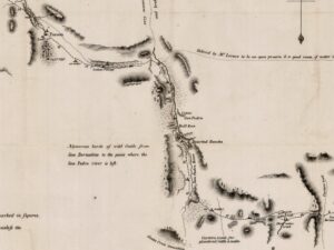
Cooke Wagon Road – Click to Expand
On this ride you will explore a tiny section of the Cooke Wagon Road via the Arizona Trail (the upper left section of the map where it is marked “Indian Village”). In particular, we love this section of the Arizona Trail (the AZT) for gravel riding and have managed to link it up with a bit of paved and gravel road to make the route a lollipop versus a simple out and back (something we are not big fans of!). And bonus! A majority of the single track is downhill.
The ride feels remote and uncluttered even though the bustle of everyday life is close by. The variety and density of the desert fauna are absolutely stunning! This is the Sonoran Desert at its best. The Cienega wetlands, distant mountain ranges, and cacti galore.
Some will find this route challenging on a gravel bike; others will find it a hoot. Pick your ride accordingly!
Caution! We do not provide turn-by-turn directions in our GPX files. Those are auto-generated by your bike computer and are usually less than 70% accurate. Learn more.
For help loading a GPX file onto your bike computer, go here.
DownloadHighlights & Remarkable Spots
Gabe Zimmerman Trailhead / @Start
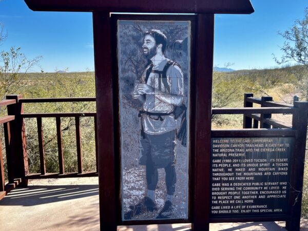
Gabe was one of the 6 people killed during the assassination attempt of Congresswoman Gabrielle Gifford in 2011. Zimmerman, who died at age 30, was a congressional staff member and a member of the Arizona Trail Association who helped get the Arizona Trail designated as a National Scenic Trail.
Davidson Canyon and Cienega Watershed / ~ Miles 0 to 1
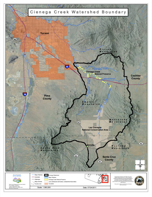
To your left on the way out is the Davidson Canyon, part of the Cienega Watershed
The watershed forms a vital wildlife corridor connecting the diverse ecosystems of the Sonoran desert with the Sky Island Mountains. Cienega Creek is one of the few remaining perennial streams in Arizona, providing critical habitat for threatened and endangered species, contains five of the rarest habitats in the Southwest, and is home to important heritage sites of the native American peoples dating back 9000 years and recent sites like Empire ranch and Kentucky Camp (mining).
Titan II Missile Silo / ~ Mile 5
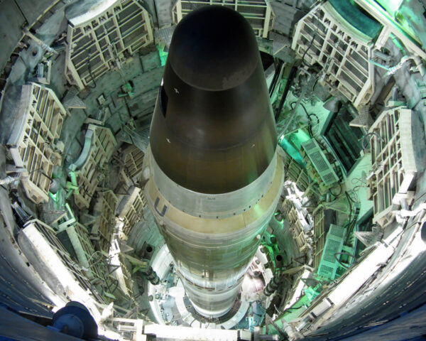
To the west by several hundred yards is a deactivated Titan II Missile Silo. The Titan II was the largest operational land based nuclear missile ever used by the United States. The silo became operational in 1963 (the Cold War era) and was deactivated in 1984 as part of President Reagan’s policy (announced in 1981) of decommissioning the Titan II missiles as part of a weapon systems modernization program. All operational Titan II silos throughout the country were demolished, including 17 sites in the Tucson area. To learn more about this part of American history we recommend a trip to the Titan Missile Museum just south of Tucson.
Arizona Trail (Passage 7) / ~ Mile 8.5

The sinlge-track trail throughout this route is part of the The Arizona Trail system. The AZT is an 800+ mile recreation trail from Mexico to Utah that climbs and descends from one Sky Island mountain range to another, traversing biomes ranging from mountain ranges to canyons to deserts and forests. About 73% of the trail is on National Forest lands, with the remaining 27% a mix of Burea of Land Management, National Park Service, Arizona State Parks, and county, private, and municipal lands.
Prickly Pear Cactus / ~ Mile 12
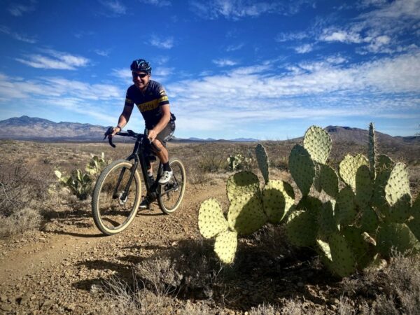
At mile 12, you cross through one of those beautifully crafted Arizona Trail gates and Sahuarita Road. The Prickly Pear are everywhere! What you don’t know about Prickly Pear: they are native only to the Americas, have over 100 different variants, have a bisexual flower with both male reproductive organs (stamens) and female parts (a pistil) and are called Opuntia. [Wikipedia]
When We Like to Ride This
Fall through spring. Spring is spectacular when the desert is green and alive with the bloom. If we lived in Tucson, this would be one of our go-to rides for something quick and easy.
Terrain & Riding
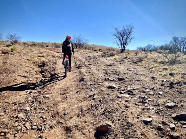
The first couple of hundred yards are uphill on loose single-track, some of the most difficult riding of the day. Soon you are on a rim above the Davidson Canyon. Below in the wetland is a swath of big Cottonwood trees. You make your way towards Viper tunnel and then cross underneath the freeway. On the other side, the single track continues, moving higher; in the far distance are the Santa Rita Mountains, with Mount Wrightson towering above.
At mile 4, you connect with the Old Sonoita Highway, a quiet road that is used mostly by local ranchers and homesteaders. The grade is gentle. At mile 7.5 you intersect the Sonoita Highway. This is a busy road. Ride single-file and be cautious. This section is 0.3 miles.
At mile 7.8 make a hard left and cross back onto a dirt road with gate.and It will wind through a rideable wash and then kick up and climb a small hill. Soon, you reach the high point of the day at ~ 4000 feet and then veer off to the right back onto the Arizona Trail.
Now, the real fun then kicks in!! The grade is mostly downhill, the trail is flowy and mostly in good condition. Cacti abound. To your right are the Empire Mountains, and far in the distance, across the freeway, are the Rincon mountains.
At mile 12, you cross through one of those beautifully crafted Arizona Trail gates and Sahuarita Road. The Prickly Pear are everywhere! The trail darts between them and around them. At mile 14, cross under the Sonoita Highway using the middle contour of the tunnel. Pop up the other side and continue the downward trend — the fauna transitions to that of a more arid desert. Soon you are back to the Viper tunnel. Cross through, climb a small hill, and wind your way in on the rim above Cienega Creek.
The Start
Gabe Zimmerman trailhead parking lot. If the lot is full, continue further north to just before the bridge. There is a second parking lot.
Food & Water
- None
Route Notes
This route is rugged and demanding. Don’t expect smooth, easy “Cadillac” gravel—plan for your ride time to take 25–50% longer than usual. Come prepared! For tips and advice, check out our Resource Page: Riding in the Desert Southwest.
We recommend a red blinky light with a looking radar detector for the paved sectors of this route. Something like a Garmin Varia.
When crossing under the freeway, you go through a long tunnel. We recommend a light, something more than your cell phone light. And … it really helps to take off your sunglasses (ugh, a stupid mistake by us.)
Route Options
At mile 7.3, there is a right-hand turn onto an old jeep road. This section can sometimes be overgrown. If so: (1) let us know so that we can get a work party to brush it out, and (2) you can continue a bit further south on the Old Sonoita Highway to the intersection with the current Sonoita Highway and go north and reconnect to the route. We are not fans of this option as it entails about .25 miles of highway riding with no shoulder, but it is doable.
You can shorten the ride by starting at the intersection of the Sonoita Highway and Sahuarita Road. There is a dirt parking lot on the west side. It is noisy with traffic, but doable. This makes the ride into a loop of 10 miles with 550 feet of gain. Go in the clockwise direction. (Lat / Long: 31.963438, -110.672297)
Love Where You Ride! Learn More
![]() A majority of this route is on sweet riding section of the Arizona Trail (AZT). Great trails like the AZT don’t happen by accident. They take planning, building and maintenance. We encourage you to give back to your local trails organization or the Arizona Trail Association by volunteering for a work party or making a donation. Let’s continue to build on our success of great routes …. for the community, by the community!
A majority of this route is on sweet riding section of the Arizona Trail (AZT). Great trails like the AZT don’t happen by accident. They take planning, building and maintenance. We encourage you to give back to your local trails organization or the Arizona Trail Association by volunteering for a work party or making a donation. Let’s continue to build on our success of great routes …. for the community, by the community!
Videos
The Ride! Prickly Pear
A quick 2-minute video of what to expect on your ride!
Prickly Pear: Did You Know?
Did you know ... that the harvested fruit may help with offsetting aging, controlling diabetes and reducing the severity of a hangover?
Be Informed!
Ridden and Reviewed by:


 Behind every route is scouting, mapping, storytelling, and a whole lot of pedal power.
Have you ridden this route? Got a question? Join the discussion!