Patagonia 50


Caution! We do not provide turn-by-turn directions in our GPX files. Those are auto-generated by your bike computer and are usually less than 70% accurate. Learn more.
For help loading a GPX file onto your bike computer, go here.
DownloadWhen We Like to Ride This
Fall to spring when the skies are clear and the temps are moderate. We would avoid this route in summer as it is very exposed to the sun. Wind could also make this route brutal. And … if it has recently rained, give it several days to let the roads dry, they are of a clay base and can turn into super sticky mud.
Terrain & Riding
You start in Patagonia which is an eclectic mix of arts and crafts, history, birding, and Border Patrol. Now before you get all freaked out about Border Patrol, we have two comments: first, Border Patrol offered us water when we were more than a few miles from camp out on the route. And, second, a few days after a major rain storm which left loads of washes impassable in other parts of AZ, “these boys” had it all grated and sorted out. Isn’t that grand!
Situated at over 4,000 feet elevation between the Santa Rita and Patagonia Mountains in the riparian corridor of Sonoita Creek, Patagonia is spectacularly rich in both natural and human assets. The distinguishing vision of our community is to protect and build sustainably upon these assets, and continuously develop our Nature Based Economy. [Town of Patagonia]
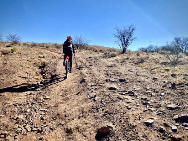
The route starts with three miles of an easy warm up on pavement(Micro-video) , then cuts into a canyon along Harshaw Creek that supports some pretty impressive trees. (The old twisty, grand ones that leave you just impressed.) After a short section of pavement, the route then evolves into oak-pine forest, climbing up and up, and through a series of washes that may run with water. At ~ mile 10 you will bump into some of the mining operation roads, along with a few short popper hills that get your heart going. The climb tops out at 5500 feet after 13.5 miles and 1500 feet of gain. The road surface varies from hard packed and fast to gravel cobblestone.

From here, it is a series of rollers for the next 4.5 miles with a gain and loss of 500 feet. At mile 18 you begin the long descent to the San Rafael valley and Lochiel (the southern most point of the day, just a few hundred yards from the Mexican border). In Lochiel, stop at the monument which is a tribute to Fray Marcos de Niza (1495 to 1558), the first European, a missionary, to enter Arizona.
The San Rafael Valley extends over 90,000 acres and lies at the headwaters of the Santa Cruz River between the Patagonia Mountains, Huachuca Mountains, and the Canelo Hills. It represents one of the finest stands of native grassland in the State home and is home to a wide variety of plants and animals. The U.S. Fish & Wildlife Service estimates the “Madrean Sky Island” bioregion (which the valley is part of) harbors the greatest diversity of mammal species in North America. Big game species are abundant in the valley and surrounding mountain ranges. White-tailed deer, mule deer, and javelina are the most common species. [Arizona State Parks]
The next 15 miles head north and then west through the grasslands of the San Rafael valley. With a little moisture the roads should be quite buzzy, but will offer up sandy bits if it’s been dry. We loved the openness … free ranging cows … and the occasional tree in the middle of the grasslands. The roads will twist and turn the further you go, but they also flatten out and then start an easy climb back out.
At mile 40 your climbing is done. It’s a yeehaw downhill(Micro-video) back to town with more oak pine forests and rocky canyons.(Micro-video) And just grand views of the whole area. The last three miles of pavement is a sweet celebration and a speedy way to get back to town.
For a great overview of the riding in the Patagonia area, give a read “Patagonia, A Gravel Utopia” by Caffeine and Watts.
The Start
Patagonia Town Park. Street side parking on McKeown Avenue. Flush toilets. Water.
Food & Water
- None.
Route Notes
Riding in the desert southwest is often very different from riding in Colorado or Oregon, with terrain that is noticeably more rugged and challenging. For tips and advice, check out our Resource Page: Riding in the Desert Southwest.
Specific to this route, most of the gravel roads in the San Rafael Valley are hard-packed and fast. However, over the last 5 to 7 years the roads (as most in southern Arizona) have become more rugged due to increased vehicular usage. Thus, our tire recommendations have changed to 50 mm+.
We recommend riding this in the opposite direction of that mapped here. Ride it counter-clockwise, this way you will be descending through the sand bit near Lochiel, not trying to climb through the sand pit.
This area is actively patrolled by Border Patrol. As a general rule, when we come across Border Patrol for the first time in the day, we stop and ask if “there’s anything we should be aware of” and we also give them our route.
The route goes very near the Hermosa Project mine (~ mile 9). Yes, the project is controversial, but we encourage you as riders to be courteous and give way to mining trucks (i.e. stop and put a foot down). There are other and better forums for debating the merits of mining than on a gravel road.
Route Options
If you’re looking for a shorter ride, check out Patagonia 30. It has most of the great elements of this ride with the exception of the San Rafael valley section.
If you’re looking for a longer ride, check out Patagonia 80. It loops further north into the Canelo Hills and further east into the San Rafael valley.
Videos
Patagonia, Arizona (Riding Gravel)
Used with permission of VeloNews.
Be Informed!
Keep it Local! Learn More

Ridden and Reviewed by:


 Behind every route is scouting, mapping, storytelling, and a whole lot of pedal power.
Have you ridden this route? Got a question? Join the discussion!