Las Cienegas (The Inner Loop)


Caution! We do not provide turn-by-turn directions in our GPX files. Those are auto-generated by your bike computer and are usually less than 70% accurate. Learn more.
For help loading a GPX file onto your bike computer, go here.
DownloadHighlights & Remarkable Spots
Las Cienegas National Conservation Area is one of the finest grassland valleys left in the southwestern US. This grassland watershed supports some ten miles of a perennial stream—a rare gem of green running through southern Arizona’s arid landscape. Together these grasslands and wetlands provide homes for a remarkable array of wildlife, including over 230 bird species, 60 mammals, 40 reptiles and amphibians, and at least five endangered species.
When We Like to Ride This
Fall through spring. Las Cienegas means wetlands in English; thus, beware! We can envision times in the spring and during the monsoon season (June – September), this could be a muddy mess.
Terrain & Riding
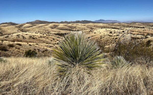
When looking for a few miles without a lot of climbing, this is the route! It loops through the Las Cienegas National Conservation Area, which is a mix of 45,000 acres of rolling grasslands and woodland bounded by the Empire mountains to the north, the Whetstone mountains to the east, and the Mustang mountains to the south. The area’s importance lies in connecting several “sky island” mountain ranges and lush riparian corridors allowing for animal migration.
The area includes five of the rarest habitat types in the American Southwest: cienegas (marshlands), cottonwood-willow riparian forests, sacaton grasslands, mesquite bosques, and semi-desert grasslands.
Miles 0 to 3 / Gardner Canyon / Gravel
The sector is slightly downhill and fast, with good gravel for the most part and some vehicle traffic. Towards the east are the Whetstone mountains (left) and the Mustang Mountains (right). The terrain is a mix of rolling grasslands, some prickly bush, and a smattering of trees. This last mile or so is at the boundary for spring / summer (April 1 – June 30) pronghorn fawning habitat. Restrictions are in place for dogs and camping activities.
Just before mile 3, you cross through Gardner Canyon and then, in a short distance, go left onto a smaller, red, single-lane dirt road.
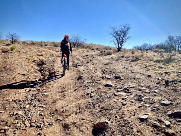
Miles 3 to 11 / Cienega Creek / Gravel
The next 8 miles run roughly south to north, loosely following the Cienega Creek. This is the most rugged sector of the day with some short rocky, gnar sections, some short steep hills, some rutted track, and a bit of sand. The road weaves and bobs, giving limited sightlines, something we like to call ‘texture.” Adding to the texture are several gates that need to be opened and closed.
The terrain includes grasslands,creosote bush (prickly stuff!), and mesquite, cottonwood, and willow trees. We saw a herd of javelina, a small to medium sized animal similar to a wild boar on this segment. Also, take note of the black tailed prairie dog reintroduction area. We looked but never saw any.
Black-tailed prairie dogs are one of five species of prairie dogs and the species with formerly the most expansive range – from southern Canada to northern Mexico. Unfortunately, over the past 150 years, their range has been reduced to less than 2%, and accordingly, their numbers have been greatly reduced. In Arizona, black-tailed prairie dogs were exterminated in 1960. Fortunately, wildlife agencies and multiple partners have worked together to re-establish the species not just in Arizona but across their historic range. In Arizona, black-tailed prairie dogs were first re-introduced in 2008 at the Las Cienegas NCA.
Miles 11 to Finish / “Powerline” Road / Gravel
Just after mile 10, you make a sweeping 180 degree turn back to the south. With this, the road quality improves. The map led us to believe that this sector is long, straight, and (maybe) boring. It is not! Yes, it does follow a powerline, not our favorite, but the road curves and bends. It gradually climbs but rolling all the while. Texture, again!
At about mile 15, you roll through Empire Gulch, a riparian area with a dense stand of large cottonwood trees. Here you will find Red-Tailed Hawks and Northern Harriers. The ranch is just ahead!
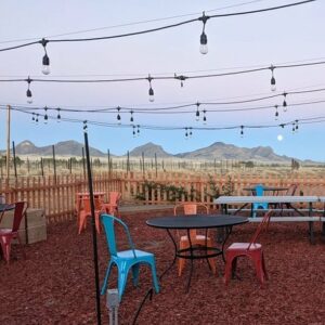
The Start
The Historic Empire Ranch. Flush toilets and water.
Food & Water
- None
Route Notes
This is desert riding—rougher and more rugged than most places in the U.S. Be prepared! Learn more about riding in the Desert Southwest on our resource page.
Route Options
Longer
For a longer ride that takes in most of the Las Cienegas National Conservation area, check out the Las Cienegas (The Outer Lollipop) route. Note, the Outer Lollipop route really demands an adventure bike over a standard gravel bike.
Our favorite route in the Conservation Area is the Las Cienegas (Gunsmoke) route. It is a combination of the best parts of the Las Cienegas (The Inner Loop) and Las Cienegas (The Outer Lollipop) routes. And … it is rideable on 40 mm tires with a bit of skill.


 Behind every route is scouting, mapping, storytelling, and a whole lot of pedal power.
Have you ridden this route? Got a question? Join the discussion!