Kentucky Camp


Caution! We do not provide turn-by-turn directions in our GPX files. Those are auto-generated by your bike computer and are usually less than 70% accurate. Learn more.
For help loading a GPX file onto your bike computer, go here.
DownloadHighlights & Remarkable Spots
Santa Rita Abbey / ~ Mile 2

Santa Rita Abbey is a monastery of contemplative nuns belonging to the international Order of Cistercians of the Strict Observance, also known as Trappists. They give themselves completely to God in love and joy, in a life centered on worshiping God and praying for the good of all people and all creation. They typically pray or attend mass six times a day, waking at 4:00 am and retiring at 8:00 pm. By baking altar breads they provide the breads used at Mass in churches across the USA.
Pit & Drift Mining Claim / ~ Miles 8.5 to 10
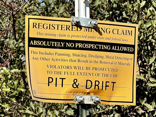
Pit and drift is a 60-acre active mining claim in Pima, Arizona. “A mining claim is a parcel of land for which the claimant has asserted a right of possession and the right to develop and extract a discovered, valuable mineral deposit. This right does not include exclusive surface rights. Mining claims are staked for locatable minerals (gold, silver, lead, etc.) on public lands.” [Bureau of Land Management]
Arizona Trail / ~ Mile 9
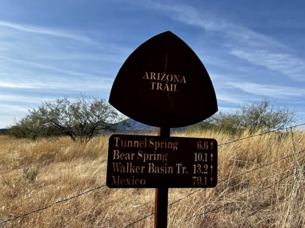
The Arizona Trail (AZT) begins at the U.S.- Mexico border and ends at the Utah border. In between, the Trail winds through some of the most rugged and spectacular scenery in the western United States. It is one of only three national scenic trails for which a connected route exists for the entire trail length.
The National Trails System Act defines a national scenic trail as an “… extended trail so located as to provide for maximum outdoor recreation potential and for the conservation and enjoyment of the nationally significant scenic, historical, natural, or cultural qualities of the areas through which such trail may pass.” [US Forest Service]
Oak Grassland Biome / ~ Miles 14 to 16
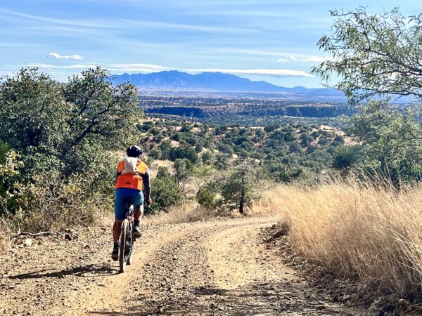
This route is one of the best exemplars of two unique Sky Islands biomes: Oak-Grasslands and Oak Woodland. Oak-Grassland is typical at 4500-6000′ in the foothills of many of the Sky Islands and throughout the majority of this ride. However, nearing the radio towers, you begin to transition into Oak-Woodlands.
Radio Towers & Melendrez Pass / Mile 11
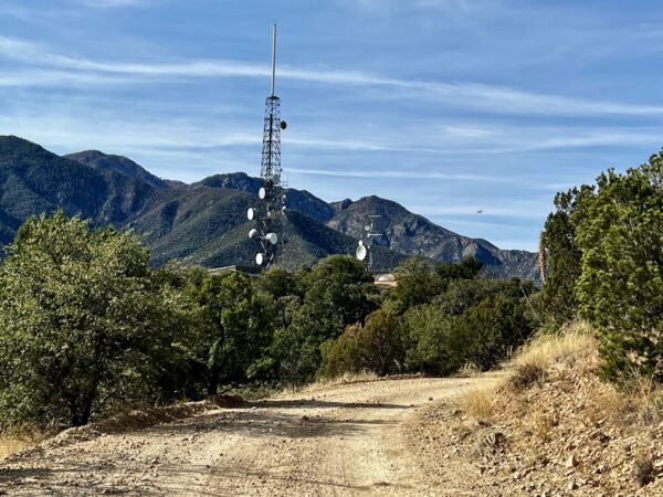
From the radio towers (also known as Melendrez pass), the high point of the day, you get expansive views east and west. To the east are the Mustang and Whetstone Mountain ranges of the Sky Islands. To the west is the Duval-Sierrita Mine. Originally developed as an underground mine in 1907, the Sierrita open pit has been in operation since 1959 and is a copper and molybdenum mining complex. The mine has one of the largest copper reserves in the United States and in the world. [Wikipedia]
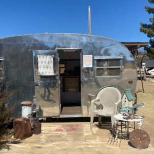
Kentucky Camp / Mile ~16
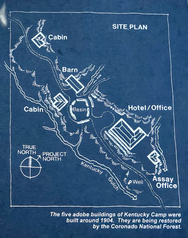
“Kentucky Camp was built in 1904 as the headquarters of the Santa Rita Water and Mining Company, whose investors hoped to collect water from the Santa Rita Mountains for hydraulic gold mining. The venture was abandoned following the mysterious death of the chief engineer the following year. The property became a working cattle ranch for the next 50 years, before being sold to a mining conglomerate. The Coronado National Forest acquired the site in 1989; since then, the Forest and volunteers have been working together to preserve the site. Kentucky Camp (and associated features related to the development of the water system and mining in the area) is listed on the National Register of Historic Places.” [Friends of Kentucky Camp]
When We Like to Ride This
This route is at elevations of 4700 to 5900 feet; thus, it is a go most of the year! We really like Fall and Spring. However, after Thanksgiving, it can be busy with hunters.
Terrain & Riding
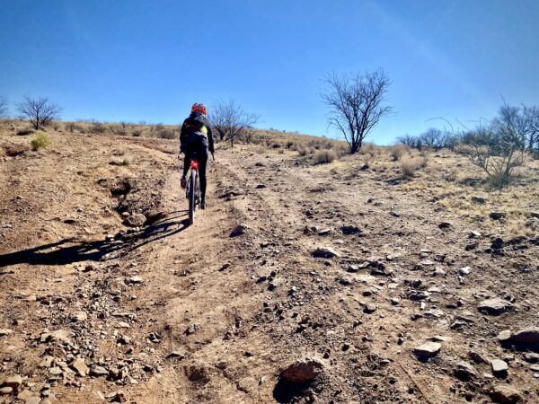
The route is a mix of hard-packed, well-traveled dirt roads and rugged jeep roads that are better suited to OHV and Quads. It can be rutted, rocky and loose, but … it is all rideable on a gravel bike with 45 mm tires and good technical skill. Some will walk short sections of the route (20 to 50 yards), some will prefer a more rugged bike. More of an adventure bike (i.e. Salsa Cutthroat), than a true gravel bike.
The terrain is stunningly beautiful! … riding through pure grasslands and oak grasslands, two of the unique biomes of the Sky Islands. You will roll up and down. The climbs are undulating as are the descents. Several pitches (up and down) are at 10 to 15% gradients, but they do not last long. The views will be deep and distant of several of the Sky Island mountain ranges, giving you a great perspective of the term Sky Islands.
The Start
A makeshift dirt parking lot on Garder Canyon Road (north side) just off the Sonoita Highway 83.
Food & Water
- None
Route Notes
The route is suited for big tires. 45 mm is pretty much the minimum you want. We rode this on a Salsa Cutthroat, more of an adventure bike than a gravel bike, with 50 mm tires and CushCore. Some will still prefer a hardtail mountain bike.
For more tips and advice, check out our Resource Page: Riding in the Desert Southwest.
The overall effort level of this route is 2+ or 3- out of 5. This takes into account both the physical demand + mental demand! There are several short “pitchey” sections with gradients in excess of 12%. The longest section is 0.35 miles with an average gradient just above 9%. This route is also technically demanding. We do not recommend this route for someone new to gravel or someone that seeks “champagne” gravel.
The route rides best in the direction as mapped. The rougher chunk is on the uphill, and the faster, smoother-flowing gravel is on the downhills. Also, it is easier to ride the Arizona Trail section on a slightly descending gradient.
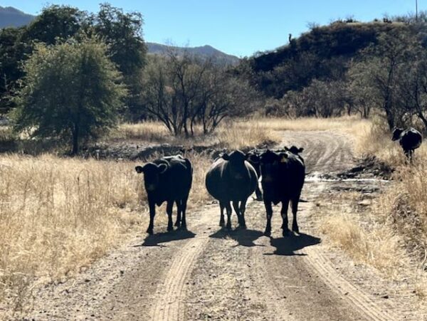
In the late fall / early winter, there will be many disbursed campers. Most are hunters. We recommend wearing a “high-viz” riding kit.
Route Options
The route can be made shorter by:
- Parking and starting at the beginning of the loop at ~ mile 2.7. (17 miles, 1800 feet of gain)
- Eliminating the leg up to the radio towers / Melendrez Pass. (17 miles, 1400 feet of gain)
A longer option is the Kentucky Camp (vai Box Canyon). (41 miles, 3700 feet of gain)
Love Where You Ride! Learn More
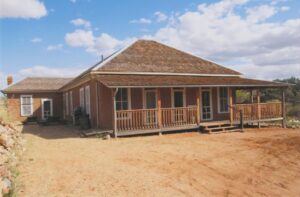 On this ride, make sure you go to Kentucky Camp! The headquarters building has been renovated and is a living history museum. Before you go, we recommend that you take a look at the following two resources:
These resources are made possible by Friends of Kentucky Camp, a chapter of the Coronado National Forest Heritage Society and a non-profit organization established to help in the preservation and interpretation of this historic site. Plan on 30+ minutes.
Videos
The Ride! Kentucky Camp
A quick 2-minute video of what to expect on your ride!
Sky Islands: What You Should Know
Learn the basics of the Sky Islands. Stuff you should really know! The geography, the lands, the plants, the animals. And their super-duper importance.
Be Informed!
Keep it Local! Learn More
Ridden and Reviewed by:


 Behind every route is scouting, mapping, storytelling, and a whole lot of pedal power.
Have you ridden this route? Got a question? Join the discussion!