J-Bob


Caution! We do not provide turn-by-turn directions in our GPX files. Those are auto-generated by your bike computer and are usually less than 70% accurate. Learn more.
For help loading a GPX file onto your bike computer, go here.
DownloadHighlights & Remarkable Spots
96 Ranch Road Outbound / Hard-packed Gravel / ~ Miles 0 to 9.5
The first 4 miles lead out straight, flat and fast. The road is hard-packed with fine “white” sand over top (a bit of an unusual sight). There is some washboard, but it is easily avoided by going far left, far right, or center. The desert is rich with Chollas and Saguaro cactus, and Palo Verde trees.(Micro-video)
Between miles 4 to 6, the route enters into the beautiful, rolling Ninetysix hills. The road now gently winds and twists upward. At mile Mile 7.5, there is a steeper pitch of 6 to 9%. In the distance are views of the Catalina mountains to the south and a set of mountain ranges to the northeast near Globe.(Micro-video)
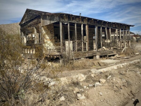
At ~ mile 9 is the 96 Ranch. According to J-Bob, the ranch house was abandoned circa 1978, and the ranch was later put up for sale. Just east of the ranch, you can see will see the stark contrast in the desert terrain of lands that have had cattle grazing to those that have not (what you have been previously riding through.)
After the ranch and a gate, the road changes texture and character to more of a one-lane road with less maintenance.
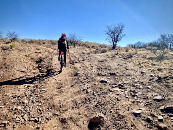
The South Hills / Rugged Dirt Track (mostly) / ~ Miles 9.5 to 13.7
Less than a 1/2 mile into this sector, you come to the wall! It is a loose, rugged, two-pitched climb that tops out at 20%. Only the strongest and most technically skilled riders will make it to the top without a bit of hike-a-bike. There is nothing as steep as this on the rest of the ride.
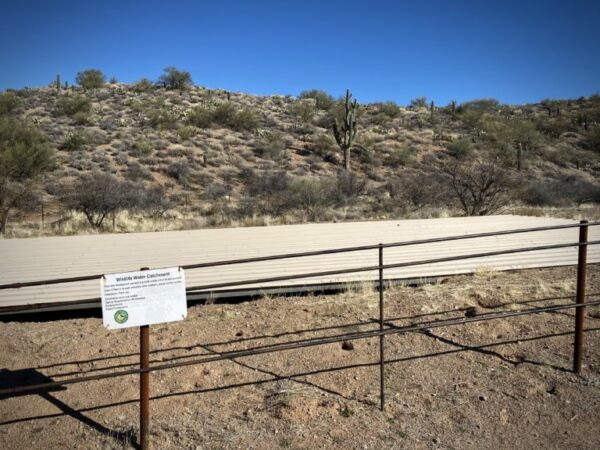
Just before the climb, on the left, there is a water catchment for desert wildlife.
Catchments typically consist of a few key elements: a trough to allow the animals to drink, a gutterlike ramp to collect rainwater, and underground tanks to store the water. Some smaller catchments hold about 2,500 gallons of water. Others can hold nearly 10,000.
The catchments were designed to be self-sufficient, and they operate without any mechanical parts or electricity, using physics to ensure consistent water delivery. In theory, rain keeps the storage tanks full, so other than occasional maintenance, the catchments would rarely need to be touched by human hands.
But with Arizona in the grip of a decades-long drought, catchments run dry. That means Game & Fish employees have to haul thousands of gallons of water into deserts, through forests, and up mountainsides. [Cronkite News Arizona PBS]
Once you crest the wall, the route contours high up on the ridge with desert views to the east and mountain views to the north. Along this sector, there are many spurious side roads, most of which lead to water tanks. Watch your turns carefully. The route gradually drops elevation, and as it does, the riding gets easier.(Micro-video)
96 Ranch & Barkersville Roads / Hard-packed Gravel / ~ Miles 13.7 to 17.6
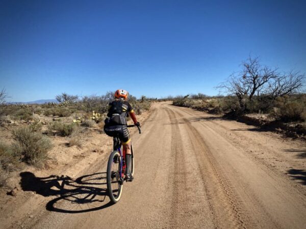
The next 4 miles are fast and hard-packed. A nice mental and physical break from the south hills sector.(Micro-video)
The North Hills Part 1 / Easy Dirt Track / ~ Miles 17.6 to 24.3

At mile 17.6, the route turns left off of the double-wide Barkersville road onto a single-wide dirt track that wanders back into the northeast edge of the Ninetysix Hills. At mile 20.4, there is a short section back on 96 Ranch Road, but you quickly veer north again on more dirt track.
The riding is easy and fun, little ups and downs with soft angled corners and firm desert terrain below your tires.(Micro-video) Early on, there is one crossing of a wash that is maybe 50 yards in length, but for us, it was rideable. There will also cross be a couple of gates to travel through.
At mile 24.3 it appears that you should continue through the gate. Wrong!
Go right up the steep loose embankment. This is the beginning of the rugged part of the north hills sector.
The North Hills Part 2 / Rugged Dirt Track / ~ Miles 24.3 to 33.6
The next 7 miles are drop-dead gorgeous and demanding. Steep up, steep down, loose, rutted, soft.(Micro-video) (Would we ride it again? Absolutely!)
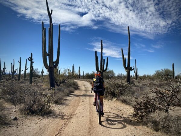
Miles 26 to 28 pass through a Saguaro Cactus forest that is absolutely stunning!(Micro-video) After this, you make a sharp left turn at mile 28.4. The demanding riding continues for another 3 miles, and then the road quality improves. The grade is slightly downhill until the next left turn onto 96 Ranch Road.
96 Ranch Road Inbound / Hard-packed Gravel / ~ Miles 33.6 to Finish
The hard work is all done. From here, it is fast, hard-packed gravel back to the start, a little over 6 miles.(Micro-video)
When We Like to Ride This
Fall through spring. We prefer this route when there is some moisture in the ground. Overall, the route is quite exposed and not best on a super hot, sunny day or a windy day.
Terrain & Riding
The route showcases the beautiful, rolling Ninetysix hills, an “off the beaten track” Saguaro Cactus forest, and some of the lushest Sonoran desert we have seen. For an area that we thought might lack character, oh, were we so wrong! [For a further in-depth look at the Sonoran desert check out these two videos by Planet Earth: Deserts Part 10 and Deserts Part 11]
The Sonoran Desert is the most biologically diverse of the four U.S. deserts. Covering 120,000 square miles of southwestern Arizona, southeastern California, and the Mexican states of Baja and Sonora, its mountains, rivers, and canyons provide luxurious habitat for numerous unique species specially adapted for heat, aridity, and intense summer monsoons. More than 100 reptiles, 2,000 native plants, 60 mammals, and 350 birds call this desert home, not only surviving here, but thriving — as long as their habitats remain intact. [Center for Biological Diversity]
The Start
Makeshift dirt parking lot at intersection of Highway 79 and 96 Ranch Road.
Food & Water
- None.
Route Notes
Riding in the desert southwest is often very different from riding in Colorado or Oregon, with terrain that is noticeably more rugged and challenging. For tips and advice, check out our Resource Page: Riding in the Desert Southwest.
Specific to this route, we recommend a adventure (gravel) bike with 2.1″+ tires. And as some suggest in the comments, front suspension would be helpful.
We recommend a red blinky light as 96 Ranch Road and Barkersville Road have light traffic.
Be on the lookout for cows, there is open grazing.
Part of the route is on Arizona State Trust Lands. For access, a permit is required. We strongly encourage you to do the “right thing” and purchase a permit. The fee is nominal.
Route Options
If you are looking for a bit more mileage,
- Combine this route with the Free Man route for a total of ~ 54 miles and 2300 feet of gain. However, this will eliminate the south hills portion of the route.
- Or start at Dudleyville on Highway 77 and use Freeman Road heading west as a stick of a lollipop.
Be Informed!
Ridden and Reviewed by:


 Behind every route is scouting, mapping, storytelling, and a whole lot of pedal power.
Have you ridden this route? Got a question? Join the discussion!