Diablito (aka: Little Devil)


Caution! We do not provide turn-by-turn directions in our GPX files. Those are auto-generated by your bike computer and are usually less than 70% accurate. Learn more.
For help loading a GPX file onto your bike computer, go here.
DownloadWhen We Like to Ride This
Fall through spring. It is a great winter ride on a sunny day; we love the look of the soft light reflecting off the mountains.
Terrain & Riding
Miles 0 to 3.5 / Puerto Canyon – The Stick / Gravel
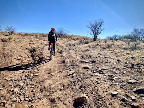
The ride heads east through Puerto Canyon from the parking area, paralleling the seasonal running Puerto Creek. This section of desert riding is unlike much of that elsewhere in the area. The trees and underbrush are thick. Rock walls jut up around you to form the canyon and in the near distance are tall unnamed peaks.
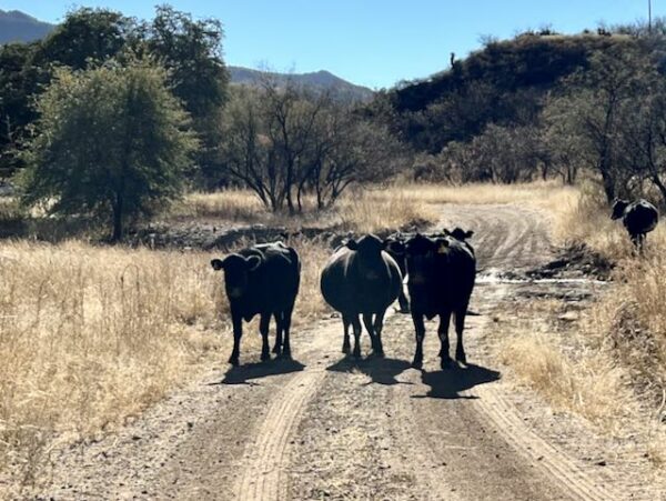
Beware of the cattle grazing. We did our “yip, yip” call, and they moved out of the way with an inquisitive look and sometimes in a startled fashion. A bike seemed like a new thing to them.
The canyon, along with a few (some people would say more than a few!) pitchy climbs, moves you from east to west through the Tumacacori Mountains (which run north to south). At mile 3, you come to the first devilish roller of the day, maybe 15% up. Shortly thereafter, you come to the second roller, a bit longer and steeper. At the crest, your cross over a cattle guard. The tall peak to the southeast is Sardina Peak, and behind you are the Santa Rita Mountains with Mt Wrightson and Mt Hopkins. If you look closely, you can see the observatory buildings atop Mt Hopkins. (And yes, there is a route that climbs the road leading to Mt. Hopkins.)
Although unimposing in elevation, the Tumacacori Mountains have sharp ridges, steep slopes, and rocky cliffs that limit the number of roads and give the area a feeling of remoteness. The vegetation is scattered evergreen oak woodlands on north-facing slopes with scrub-grasslands on south-facing slopes. Mesquite and acacia shrubs are common, as are agaves and sotols.
Miles 3.5 to 7.5 / Red Spring Pass / Gravel
You will think that after cresting the ridge [at a cattle guard], it is all downhill from here. Ohhh, you are so mistaken!! The next 3.4 miles are challenging, bringing you up, over, and down Red Spring Pass [at ~mile 4.8] It can all be ridden. A couple of times, Gravel Girl couldn’t find a gear quick enough, resulting in a bit of push biking. Just after you see the first windmill of the day, to your right, the route flattens.
Miles 7.5 to 12.5 / Moyza Canyon / Gravel
The next 5.5 miles are through the Moyza Canyon. The riding is slightly downhill, some of the time through the wash — all rideable (at least for us, it was). The texture of the terrain is much different than the first miles. Desert bush and gnarly, tangled trees. Few if any cactus.
At the second windmill and cattle-yard of the day pass through the gate. The road is a designated access road, even though it is bounded by private property part of the way.
Miles 12.5 to 18.6 / Papa Chon / Gravel
At mile 12.7, you reach the low point of the day and a gate. Go hard right; do not pass through the gate. There is an interesting grave marker under a big tree marking Papa Chon. The riding is about to get difficult and demanding again.
Just after the third windmill and a short pitch of a hill, you encounter this rubbly mess. It is not long, and surprisingly all rideable.
At ~ mile 13.5 you encounter the longest wash of the day, about a mile in length. For us, it was all rideable, but a power suck. At the end of the wash, you make a hard right turn and climb a short, nasty pitch.
From here, the route continues to undulate up and down all the way back to the “stick”. More up than down. And steep! Several pitches are at 15 to 20%, and the last pitch is at 25%. Here is where Gravel Girl encountered a bowhunter on a quad OHV (off-highway vehicle). The conversation went something like this.
Hunter: Hi. Ma’m, do you know where you are?
Gravel Girl: Yep! I know exactly where I am at?
Hunter on OHV: Are you sure?
Gravel Girl: Yep! But, you can tell my husband up there that I want a divorce. (Said with a smile.)
Miles 18.6 to Finish / Puerto Canyon – The Stick / Gravel
Now, back onto the stick of the lollipop, there is one last climb to the saddle. From here back to the start is ~3 miles slightly downhill with a loss in elevation of 500 feet. Even though we were tired and a bit beat up, the beauty of this last stretch of riding through Puerto Canyon is breathtaking. The Santa Rita mountains in front of you, Diablo Mountain to your left.
The Start
A Forest Service dirt parking lot with picnic tables. The last 3.7 miles to the parking area are on a rough gravel road. Google / Apple maps may not route you correctly; use this waypoint (31.629080, -111.102176) to access the gravel road. It is a difficult entrance to find; however, it is posted with a sign stating “Hunter Access”.
Food & Water
- None
Route Notes
Most importantly, this is an adventure bike route; it is not really built for a standard gravel bike with 40 mm tires. You will want something with a 50 mm+ tire. We rode the route on Salsa Cutthroats on 55 mm Fleecer Ridge tires, tubeless with CushCore. We also ran low air pressure, 17 psi rear, 15.5 psi front for Captain O.
There is open grazing along the route. Don’t yell and scream at the cows; this only raises their anxiety levels. Take a look at this page on how to pass by cows safely and without confrontation.
This area is also a popular hunting area in the late fall (rifle) and winter (bow). We recommend wearing a “high viz” kit.
Route Options
Longer
You can lengthen the ride by starting at the access point to the gravel road leading out to the start of the route. There is a parking area here as well. This makes the ride ~ 7 miles longer with 800 feet of additional elevation gain for 30 miles and 3200 feet of gain.
Lat / Long: 31.629080, -111.102176
Be Informed!
Ridden and Reviewed by:


 Behind every route is scouting, mapping, storytelling, and a whole lot of pedal power.
Have you ridden this route? Got a question? Join the discussion!