Cochise Stronghold


Caution! We do not provide turn-by-turn directions in our GPX files. Those are auto-generated by your bike computer and are usually less than 70% accurate. Learn more.
For help loading a GPX file onto your bike computer, go here.
DownloadHighlights & Remarkable Spots
Cochise Stronghold Ranch / ~ mile 1
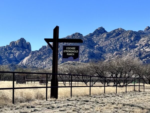
After the Apache Wars ended in 1886, Cochise Stronghold drew the interest of white settlers, ranchers, and investors. Martin Costello, a saloon keeper, mining investor, and businessman from Tombstone, acquired substantial land and mining claims, part of which is now the Cochise Stronghold Ranch. In 2005, the current owners obtained the property and discovered its remarkable preservation since ancient times. Their mission is to protect the natural habitat and historical artifacts while offering educational opportunities for future generations to cherish. [Cochise Stronghold Ranch]
Coronado National Forest / ~ miles 3-7
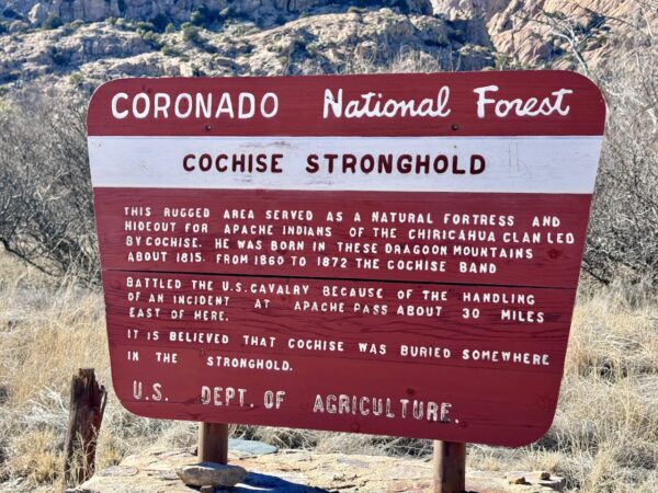
Coronado National Forest encompasses approximately 1.78 million acres, and offers a wide range of landscapes, from high mountains to desert valleys. Many of the mountain ranges in the Coronado National Forest, including the Chiricahua and Dragoon Mountains, are Sky Islands – isolated mountain ranges that rise up out of the surrounding desert floor. Sky Islands connect the Sierra Madre Occidental in Mexico with the Rocky Mountains. [USDA]
Shaw House / ~ mile 4
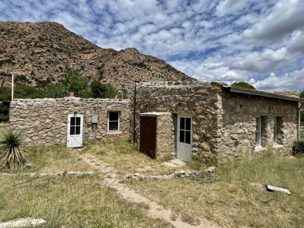
Mrs. James Birnie Shaw purchased 80 acres from John Rockfellow in the 1920’s and proceeded to grow a diversified crop of tree fruits, including nuts and peaches. Originally built of adobe, the Shaws expanded with stone masonry. Her son, Richard Shaw, donated the house and surrounding land to the Forest Service in 1990. The Shaw House is available for vacation rentals through recreation.gov (currently unavailable due to renovations). [USDA]
Rockfellow Dome / ~ mile 4
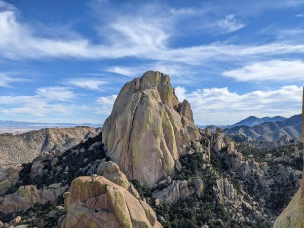
Named for John Rockfellow, an 1800’s Arizona trailblazer who attempted to homestead in the Cochise Stronghold during the Apache Wars, Rockfellow Dome presents a challenging hike to those who embark on the 1.5 mile trail. The dome is a great example of the geological forces that have helped create this landscape. Please note that Peregrine Falcons often nest on these cliffs from February to June; respect any closures. [USDA]
History + Nature Hike / ~ mile 5
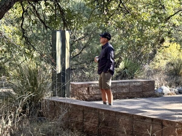
The 400-foot history trail narrates the Stronghold’s story, focusing on the Chiricahua Apache. Across the bridge to the left, the Stronghold Nature Trail begins, offering a self-guided experience with informative signs about the local plant life and its uses by both people and animals. This 0.4-mile trail is an easy walk, with steps in steeper sections.
Pearce Ghost Town / ~ 15 minute drive from start
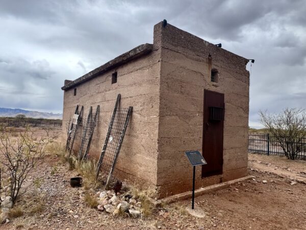
This is the historic Pearce jail. The on-site kiosk reads: “In 1915 Constable Charles Webster advised the Board of Supervisors in Tombstone that a jail was needed in Pearce. G.M. Porter of Bisbee was awarded the contract and later that year the jail was completed at a cost of $615.45. Constructed of layers of poured concrete reinforced by rebar and with a flat roof, the jail has two cells. The walls are ten inches thick and ventilation is provided by six windows. The two doors are iron. The Jail continued in use as a holding facility until the mid 1930s.” Lat/Long: 31.905490, -109.821435
Terrain & Riding
Terrain
Cochise Stronghold cuts through the Dragoon Mountains, a Sky Island mountain range (listen the podcast in the sidebar, or on mobile at near the bottom of the page) located in southeastern Arizona. These mountains stand out as forest-covered islands amidst a vast desert landscape. The Dragoon Mountains feature a variety of environments, from desert grasslands to oak and pine woodlands on the slopes facing north of 7,532-foot Mount Glenn. This diversity of habitats supports a wide range of wildlife. Numerous canyons, carved by creeks that flow intermittently from concealed springs, traverse the mountain range.
Riding
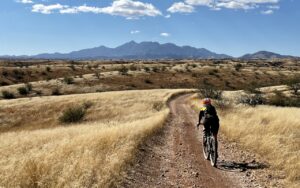
Mostly hard-packed double-lane gravel road. There is a short bit of pavement at the beginning and end. Light traffic.
Food & Water
- ~ mile 4.5 / At the Cochise campground. Seasonal.
Route Notes
The History Walk goes clockwise. At the start go left, think of this as the 6 o’clock position. The nature walk also goes clockwise. After crossing the bridge go left. Bring a bike lock and comfortable walking/biking shoes.
We recommend a red blinky light with rear looking radar detector like a (i.e. Garmin Varia). The gravel roads along this route have some traffic, and it can be difficult to hear traffic approaching from behind. A Varia type of device really helps.
Experience history firsthand by spending a night at one of the restored, historic cabins available for rent in the East Stronghold. Originally built of adobe in 1896, the Shaw House was expanded with stone masonry in the 1920s to accommodate the Shaw family, who planted fruit and nut trees here. The brick masonry Half Moon Ranch was built in the early 1970s. A pond on the property makes for excellent wildlife viewing. Both cabins hold up to 10 people. Half Moon Ranch has a corral for up to 8 horses. There is also both dispersed and developed camping.
See this Forest Service brochure for all the details.
Love Where You Ride! Learn More
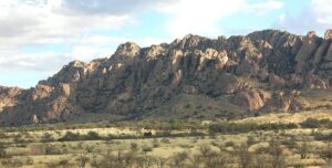 The Dragoon Mountains are a rugged range within the Chiricahua Mountains. Formed approximately 65 to 150 million years ago by tilting and uplifting, they are composed of rugged cliffs, granite domes, and deep canyons with hidden springs and streams. Time, wind and water have taken their toll, leaving granite spires, deep crevasses, sharp precipitous ridges and a maze of boulder fields, characteristics which the Chiricahua Apaches used to great advantage during the late 19th-century Apache Wars. The mountains were named in the 1850s after the “Dragoons,” mounted soldiers armed with long guns sent by the American and Mexican governments to battle the Apaches.
Videos
The Ride! Cochise Stronghold
A quick 2-minute video of what to expect on your ride!
Podcasts
The Sky Islands: Uncomfortable Issues with Sarah Swallow
Sarah Swallow is a world-renowned bikepacker, route developer, and storyteller who has spent a significant amount of time riding and exploring Southern Arizona. In this podcast, she shares her perspectives of the beauty and uniqueness of the Sky Islands, but also the [...]
Be Informed!

Keep it Local! Learn More

Ridden and Reviewed by:


Have you ridden this route? Got a question? Join the discussion!