Charlie Bell
Permit required! Closed March 15 to July 15. See details in Notes & Options tab.


Caution! We do not provide turn-by-turn directions in our GPX files. Those are auto-generated by your bike computer and are usually less than 70% accurate. Learn more.
For help loading a GPX file onto your bike computer, go here.
DownloadWhen We Like to Ride This
Fall through early spring. We love this route from late February to April, when the flowers are in bloom. Ideally, we like to do this route in the early morning when the sun begins to rise. The lighting is magical, and the opportunity to see wildlife is greatly enhanced.
Note, some years have a season fawning closure for Sonoran Pronghorn (antelope). This is usually from early spring (mid-March) through early summer (mid-June); please see the Cabeza Prieta NWR website for more details.
Terrain & Riding
Seeing a Sonoran pronghorn in the wild is a rare and thrilling experience. The Sonoran pronghorn is smaller and lighter colored than its North American relatives. An adult Sonoran pronghorn stands about 3 1/2 feet high at the shoulders, weighs 90 – 125 pounds, can run at speeds of 60 miles per hour, and has a 270-degree field of vision for up to four miles. When startled, they often show their white tail and rump patch before fleeing. Sonoran pronghorn are superbly adapted to their desert environment, being able to tolerate high temperatures and go without water for extended periods of time.
The Sonoran pronghorn was federally enlisted as an endangered species in 1967. Following a severe drought, only 21 Sonoran pronghorn remained alive in the United States in 2002. In cooperation with the Arizona Game and Fish Department and many other partners in the U.S. and Mexico, the U.S. Fish and Wildlife Service started a captive breeding program to increase Sonoran pronghorn numbers and ensure their survival
The Start
Cabeza Prieta National Wildlife Refuge Headquarters. Parking, water, and flush toilets.
Food & Water
- None
Route Notes
To access the Cabeza Prieta NWR you need to obtain a permit. Each person in your party must have a permit AND you must electronically sign in and out each time you access the Wildlife Refuge. Trust us, we have been stopped several times and asked for our permit!
For logging in and out (on-line) this area is known as Cabeza Prieta.
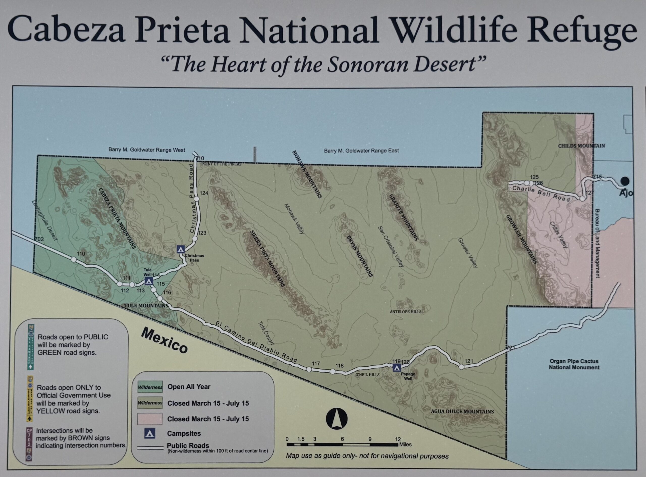
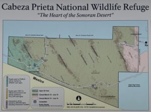 This area of the Cabeza Prieta National Wildlife Refuge is closed March 15 to July 15 for Sonoran Pronghorn fawning. Learn more about this endangered animal in our podcast.Click on image to see exact closure area.
Our choice for tires would be 50+ mm with reduced pressure. There is nothing along the route that would preclude 40 mm tires; however, the ride quality will be harsher.
Bring a lock for the hike portion. A cable lock that can go around a tree will work as you will find a number of trees at the wash, Daniel’s Arroyo. Bring hiking shoes.
If you do this route, we could use your help with a few pictures of:
- the cattle guard entering Cabeza Prieta
- locking up bikes
- the hike
- petroglyphs
- Charlie Bell Well
- some of the mural art from the town of Ajo
Route Options
This route is perfect for an ebike! The hike is 5 miles, which is ~ 2 hours. Exploring for petroglyphs is another 1 to 2 hours. The 30-mile bike out and back is an additional 3 to 4 hours. Thus, by standard bike, the adventure is 6 to 8 hours. An ebike could make the time much more manageable.
Podcasts
The Endangered Sonoran Pronghorn
In Southern Arizona you might be lucky enough to see Sonoran pronghorns. In this podcast, we learn from Stephanie Fuest, the lead wildlife biologist for the recovery of the endangered Sonoran pronghorn. She walks us through the history of the species in the area, recovery efforts, and [...]
Keep it Local! Learn More
Ridden and Reviewed by:


 Behind every route is scouting, mapping, storytelling, and a whole lot of pedal power.
Have you ridden this route? Got a question? Join the discussion!