Bring a Fork


Caution! We do not provide turn-by-turn directions in our GPX files. Those are auto-generated by your bike computer and are usually less than 70% accurate. Learn more.
For help loading a GPX file onto your bike computer, go here.
DownloadHighlights & Remarkable Spots
West Desert Trails / ~ throughout
“The West Desert Trails are unmaintained trails located on approximately 1,830 acres of open space adjacent to the Sierrita Mine in Green Valley, Arizona. This property was purchased by Freeport-McMoRan Sierrita Inc. in 2012. In 2014, Sierrita completed the installation of groundwater extraction wells and related infrastructure in accordance with the sulfate mitigation effort.” [West Desert Trails]
Twin Buttes Mine and Tailing Pond / ~ throughout
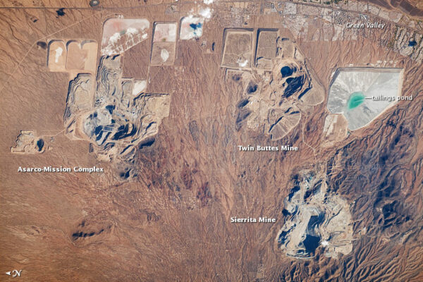
These open pit mines create the two massive walls that border the West Desert Trails to the west and to the north. The Tailing Pond is to the south and the Sierrita Mine is to the north. Freeport McMoran owns these properties and the Asarco-Mission Complex and Sierrita Mine next to the Twin Buttes Mine in Green Valley.
Santa Rita Mountains / ~ throughout
The incredibly biodiverse and important Sky Island range that is to the East during this ride. The tallest mountain, Mr. Wrightson, reaches up to 9,500 feet and is a popular and challenging hiking destination. One of the most popular spots in the range, Madera Canyon, has some of the best birding in the country. The rare and beautiful Elegant Trogon nests in Madera Canyon. The Whipple Observatory is a nationally renowned observatory on Mount Wrightson’s sister peak Mount Hopkins.
Santa Rita Mountains Lookout Bench / ~ mile 7.5
The perfect place for a mid-ride snack break with an amazing view of the Santa Rita Mountains.
Crested Saguaro / ~ mile 11.5
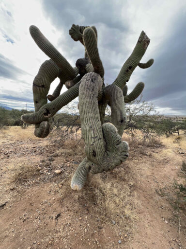
“Saguaros sometimes grow in odd or misshapen forms. The growing tip occasionally produces a fan-like form which is referred to as crested or cristate. Though these crested saguaros are somewhat rare. Biologists disagree as to why some saguaros grow in this unusual form. Some speculate that it is a genetic mutation. Others say it is the result of a lightning strike or freeze damage. At this point, we simply do not know what causes this rare, crested form.”[National Park Service]
The most incredible crested saguaro we have ever seen (and we’ve seen quite a few!)
When We Like to Ride This
We would ride this all year except in the summer when it’s hot. There is minimal shade and at this low elevation, it would be quite toasty. Going in the spring when the cacti are flowering would make this route even more magical. Please do not ride this route after it rains, riding on wet trails will damage them!
Terrain & Riding
A lot of flowy, twisty, fun single-track with a dab of double-track. There are a few chunky technical sections and several dozen wash crossings. Not long, the in and quickly out kind.
This should not be your first ride on single-track trails with a drop bar gravel bike. This route is cactus technical. You are up close and personal with a lot of cactus and a steering miscue can be painful!
The payoff: big mountain views, tall lush grasses and gorgeous green prickly cactus everywhere. We think this is a hidden gem of a ride!
The Start
A small dirt pullout off of Duval Mine Road with spots for 2-3 cars. There was only 1 other car when we arrived. If the pullout is full there are other access points, which can be found here.
It is easy to miss the pullout if you are heading southwest on Duval Mine Road. The pullout is on the left shortly after the residential area of Green Valley ends. If you see a pair of white tanks in the desert to the left you have gone too far. Flip around and it will be the first right after the white tanks.
Food & Water
- None.
Route Notes
“The WDT area is owned by Freeport-McMoRan Sierrita Inc. and contains a series of water mitigation wells. These wells require servicing by Freeport-McMoRan and its designated contractors, which involves movement of mobile equipment and well rigs. For everyone’s safety, please give mobile equipment the right-of-way, and do not interfere with crews working in the area.” [West Desert Trails]
“Please be aware that the land within the West Desert Trails is also leased to local cattle ranchers and there remains the potential to come in contact with cattle” [West Desert Trails]
You need a free permit to ride West Desert Trails.
If you don’t know what cacti removal tool to pack we reccomend bringing a stright cutlery fork. The fork’s handle gives you leverage and keeps you far away from the spines.
There are many wash crossings that are not deep but are steep and can be jarring, think drainage ditches. We rode this route on our Salsa Cutthrouts (an adventure bike) with 50mm tires and CushCore inserts.
Love Where You Ride! Learn More
![]() Sonoran Desert Mountain Bicyclists advocate for cyclists’ access to trails. They repair, restore, maintain, and build trails, and educate cyclists and other trail users on trail etiquette. They’ve partnered up with government agencies to reopen old forgotten trails on Mount Graham, they saved the Fantasy Island Trail System from development and built a community bike park. They are a huge force for good in the cyclist community in Tucson.
Sonoran Desert Mountain Bicyclists advocate for cyclists’ access to trails. They repair, restore, maintain, and build trails, and educate cyclists and other trail users on trail etiquette. They’ve partnered up with government agencies to reopen old forgotten trails on Mount Graham, they saved the Fantasy Island Trail System from development and built a community bike park. They are a huge force for good in the cyclist community in Tucson.
Please consider supporting them by donating your time or monetarily by donating or by becoming a member.
Or, alternatively consider supporting one of your hometown organizations that does something similar. Either way, get involved and protect what is precious to you!
Videos
The Ride! Bring a Fork
A quick 2-minute video of what to expect on your ride!
Podcasts
Jumping Cholla: Does This Cacti Really Jump?
Have you ever encountered a jumping cacti? More specifically, the jumping cholla cactus in Arizona? If you have ridden our Rock Art or Bring a Fork routes in Arizona then you have dodged more than a few of these [...]
Ridden and Reviewed by:


 Behind every route is scouting, mapping, storytelling, and a whole lot of pedal power.
Have you ridden this route? Got a question? Join the discussion!