Black Hills


Caution! We do not provide turn-by-turn directions in our GPX files. Those are auto-generated by your bike computer and are usually less than 70% accurate. Learn more.
For help loading a GPX file onto your bike computer, go here.
DownloadHighlights & Remarkable Spots
Cinder Mine & Interpretive Site / ~ Mile 3.6
Starting at about mile 2.8 (and continuing past), you can see an old mine shaft up in the hillside on the left. At mile 4, you go past the old cinder mine where there is an interpreter kiosk on your left.
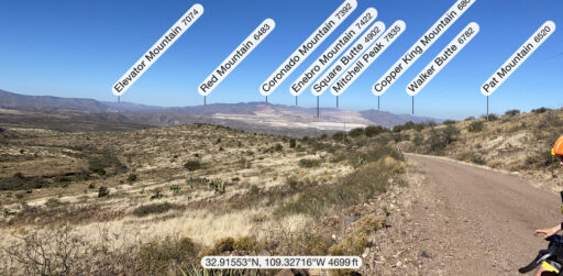
Mt Graham / ~ Mile 4.2
After taking the switchback to the right, looking back you can begin to see the surrounding mountain ranges in the distance and views of Mount Graham (10,724 feet) and the International Observatory. There are 3 research telescopes located at the observatory: (1) The Vatican Advanced Technology Telescope, (2) Heinrich Hertz Submillimeter Telescope, and (3) The Large Binocular Telescope.
Canyon Overlook Picnic Area / ~ Mile 7
If you look straight out, you can see the big mines in a distance and hear the sounds of the mines at work.
Canyon Overlook Picnic Area / ~ Mile 9
“The first settlers to this region used the grasslands to feed their livestock. But these hillsides were dry, and without water to drink, the grasses could not be used by sheep, cattle or horses.
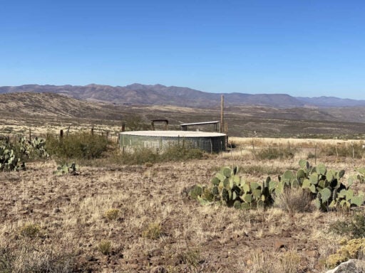
Livestock first grazed close to the Gila River. Over time, ranchers found innovative ways to provide water further from the river. Windmills pumped water from the ground, and stock ponds were built to catch rain water. To provide a more dependable source of water for cattle and wildlife, ranchers now pump water from the Gila River through a system of pipelines and storage tanks. In places, this water system extends over 5 miles from the river.”[Kiosk on the Black Hills Country Byway]
Mining Kiosk / ~ Mile 13
The Phelps Dodge Morenci mine is the largest copper mine in the Northern Hemisphere, containing some of the richest copper deposits in the world. The kiosk at mile 13.3 talks about the early mining history (dating back to the late 1800s), the process of extracting copper from the rock, the company mining towns of Morenci and Clifton, the physical layout of the mine, protecting our natural heritage, and the uses for copper.
The Stone Walls / ~ Mile 16
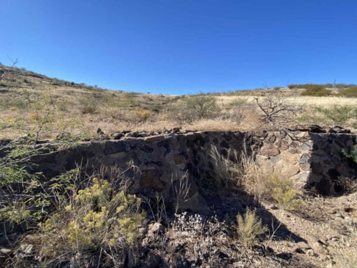
In the late 1800s and early 1900s periods of drought and too many livestock resulted in the loss of vegetation in this region. With little vegetation to protect the soil, heavy rains eroded the topsoil from these hillsides. These low walls, called spreader dykes, were built in the 1930s by the Civilian Conservation Core to keep the soil from washing away.
Did they work? Today conservationists agree this erosion control project was a success. [Kiosk on the Black Hills Country Byway]
When We Like to Ride This
In the late fall / early spring when the trees near the Gila River are in bloom or turning color. This makes the turnaround point special.
Note, the route is at elevations between 3800 feet and 5500 feet. Thus, there may be riding opportunities most of the year except June through August. The route is exposed to sun and wind.
Terrain & Riding
This is an up-down, up-down route. The turnaround point is at the low point of the day, but to get there, you first climb up and over Gutherie Peak saddle and then descend to the turnaround point at the Gila River. This is very different than a pure down-up route.
Although there is a lot of climbing on this route, it doesn’t beat you up. The gradients are pretty consistent at 4-6%. The summit / saddle is triple-peaked; thus, your roll a bit up / down at the higher elevations.
The terrain is a high desert mix of mesquite trees, grasses, prickly pear cactus and desert scrub. The views are wide and expansive, something we loved about this route. Initially, there are views of Mt Graham and the Pinaleno Mountain range to the southwest. After Gutherie Saddle, the views are to the north of Coronado Ridge and Natanes Mountains.
The roads are not rough, and there are no excessive pitchy, powerful climbs.
The Start
Off of U.S. Highway 191 where the dirt road begins. There is a little pull-out / kiosk on the left after you turn off the highway.
Food & Water
- None.
Route Notes
For the finishing descent, we took some air out of the tires and somewhere along the day we picked up some jump heads.
Route Options
There is an alternate start for the route that includes a rockhounding spot and the historic Twin C Ranch. “The Twin C Ranch has been operated by the family of Cipriano and Matilda Cueto since 1929. In the early days the family worked hard, laboring long hours to build the ranch. The ranch was dry, and water had to hauled to the ranch house from the Gila river 6 miles away.” [BLM Kiosk]
The alternate start miles are a bit more rugged and technically demanding, but worth it. You reconnect with the original route at mile 2.8.
Parking is at a dirt lot just off Highway 191 to the north side.
Lat / Long: 32.847821, -109.383563
RideWithGPS: Black Hills (Alternate Start)
Get Involved!
![]() The Gila Box National Conservation Area is a very special riparian ecosystem abounding with plant and animal diversity. A canyon section, known as the Gila Box, is composed of patchy mesquite woodlands, mature cottonwoods, and sandy beaches. Impressive Gila Conglomerate cliffs tower more than 1,000 feet above the Gila River, and bighorn sheep are commonly spotted.
The Gila Box National Conservation Area is a very special riparian ecosystem abounding with plant and animal diversity. A canyon section, known as the Gila Box, is composed of patchy mesquite woodlands, mature cottonwoods, and sandy beaches. Impressive Gila Conglomerate cliffs tower more than 1,000 feet above the Gila River, and bighorn sheep are commonly spotted.
Though less well-known and more remote than other popular public lands, national conservation lands represent our nation’s natural, cultural and outdoor heritage. They are managed by the largest caretaker of public lands in America, the Bureau of Land Management.
If you enjoy this place, we encourage you to make a donation to the Conservation Lands Foundation (or to a similar organization in your hometown area). The Conservation Lands Foundation is the only national movement of grassroots advocates to protect, restore and expand National Conservation Lands.
Videos
The Ride! Black Hills
A quick 2-minute video of what to expect on your ride!
Ridden and Reviewed by:


 Behind every route is scouting, mapping, storytelling, and a whole lot of pedal power.
Have you ridden this route? Got a question? Join the discussion!