Ajo Peaks Tour


Highlights & Remarkable Spots
The Lead Out / Paved & Hard-packed Gravel / ~ Miles 0 to 5
From the Ajo Town Plaza, head southwest towards the mine, traversing the local streets. At ~ 0.7 miles, and after a short uphill pitch, there is a small building to your left across a parking lot by 50 yards. This is the mining museum and the best place to get a deep look into the mine.
The New Cornelia mine is a currently inactive open-pit copper mine located just outside the town of Ajo, which was built as a company town to serve the New Cornelia mines. Full-scale mining using steam shovels was started in 1917, making the New Cornelia the first large open-pit mine in Arizona. Copper production from the mine totaled 6.304 billion pounds of copper, worth about US$20.8 billion at the 2010 copper price of $3.30/pound. [Wikipedia]
A short distance further up the road is the Ajo Historical Society Museum. Another stop that we recommend.
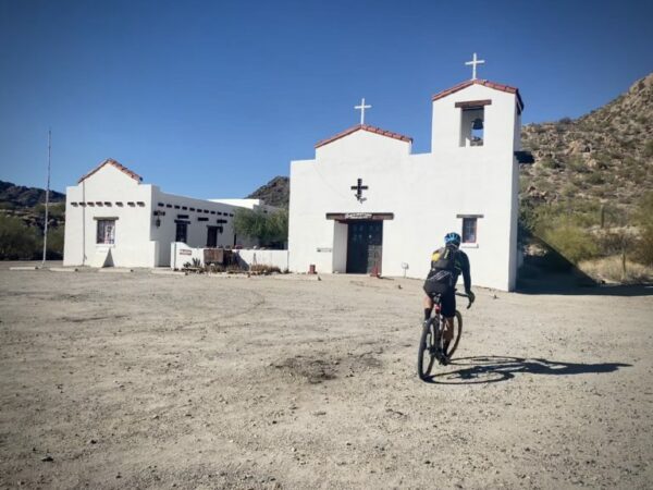
Located in the old St. Catherine’s Indian Mission, the museum houses many artifacts and mementos from Ajo’s past. The displays include a complete blacksmith shop, a dentist’s office, and an early print shop. [Ajo Chamber of Commerce]
After the museum, the ride begins in earnest. Head north, at the 2-mile mark, make a left onto Rocalla Avenue [paved]. The road pitches up, turns south, changing in name to Alley Road and gravel. And wow! The views of the Little Ajo Mountains reveal.(Micro-video) The two most prominent peaks are Noth Ajo Peak (to the right) and Ajo Peak. They differ in height by a mere 20 feet and appear to be the tallest in the range, but they are not. That distinction goes to Black Mountain, which dominates in the latter half of the ride.
8113 Roads (BLM Lands) / Rugged Dirt TrackLands / ~ Miles 5 to 16.5
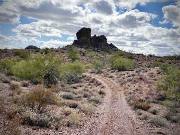
At mile 5, make a sharp right and head directly towards North Ajo Peak.(Micro-video) The next 11.5 miles will be on a series of the 8113 roads, all with a letter designation such as 8113F.
The route swings to the right of North Ajo peak and then slowly circumnavigates North Ajo Peak and Ajo Peak in the counterclockwise direction. At times the riding will be rugged and rocky. Never flat. All rideable with skill.
As you circle to the south, in the distance is Organ Pipe Cactus National Monument and to the west is Cabeza Prieta National Wildlife Refuge, home to the rare Sonoran Pronghorn. The flat mountain range with a distinct notch is the Growler Mountains.
At mile 9.7, the route picks up a larger dirt / gravel road where the riding is less technically demanding.(Micro-video) This lasts for about 2.5 miles until you take a right onto a smaller dirt road. If you continue just a bit further beyond the right turn, there is the Darb Wells cemetery, a burial ground for native American Indians. Please visit with respect.
The riding is again rugged and is so for the next 4.25 miles,(Micro-video) but the highlights of this sector are sweeping views of the New Cornelia mine, Locomotive Rock, and Black Mountain – the large imposing mountain to the east.
Scenic Drive / Hard-Packed Gravel Road / ~ Miles 16.5 to Finish
The finishing miles of the route are on Scenic Drive, a well-traveled gravel road that is used extensively by disbursed campers in the winter. Surprising to us, and not sure why the grade is slightly uphill for the 4 miles. North Ajo Peak, Ajo Peak, and the New Cornelia mine are again the dominant views.(Micro-video)
At mile 20.4, you top out, and it is all downhill from here.(Micro-video) First on gravel, then on paved as you come back into town. Exercise a bit of caution on the city streets, as it is easy to get going a bit too fast.
Now, go enjoy everything the Town Plaza has to offer. Food, drink and lovely park.
When We Like to Ride This
Fall through early spring. We love this route in the winter; the soft light gives the mountains a radiant “glow”. We imagine that the springtime could be spectacular when the desert is in bloom.
Note, some years have a season fawning closure for Sonoran Pronghorn in the lands south of Scenic Drive. This is usually from early spring through early summer, please see the Cabeza Prieta NWR website for more details.
Terrain & Riding
This route is a hidden gem. From the town of Ajo, what you don’t see and don’t expect are the majestic beauty of the Little Ajo Mountains and the Sonoran desert. Jagged peaks, distant mountain ranges, and cactus … all kinds of cactus (Saguaros, Ocotillos, Chollos, Organ Pipe).
Even though the ride has only 1100 feet of gain, it is not flat! It is a continuous melody of short-pitched hills with a periodic wash crossing to strike a strong note. Captain O (one of the review authors) remarked, “this is really COOL desert riding!”
But before you set your bike in motion, take a moment to learn about the history, heritage, and tradition of Ajo
Ajo sits at a tri-national intersection of peoples and cultures, where influences from the indigenous Tohono O’odham Nation, the Mexican state of Sonora, and the Southwest borderlands of the United States are all readily apparent. And although mining is deeply rooted in the history and architecture of Ajo, the town continues to evolve into a community that is carving out its own identity while still respecting the traditions of its past. [Local First Arizona Foundation]
.
The Start
The Ajo Plaza, a Spanish Colonial Revival style town square featuring a central park surrounded by retail shops, a post office, and restaurants.
Food & Water
- None.
Route Notes
The route is more suited to an adventure bike with 50+ mm tires.
We recommend a red blinky light as Scenic Drive has some light traffic.
Route Options
If you are looking for a bit more mileage,
- Combine with Copper Canyon route (yet to be published)
- Add in the John the Baptist option (yet to be published)


Have you ridden this route? Got a question? Join the discussion!