


Caution! We do not provide turn-by-turn directions in our GPX files. Those are auto-generated by your bike computer and are usually less than 70% accurate. Learn more.
For help loading a GPX file onto your bike computer, go here.
DownloadHighlights & Remarkable Spots
Redington Road / Miles 0 to 9 and 21 to 30
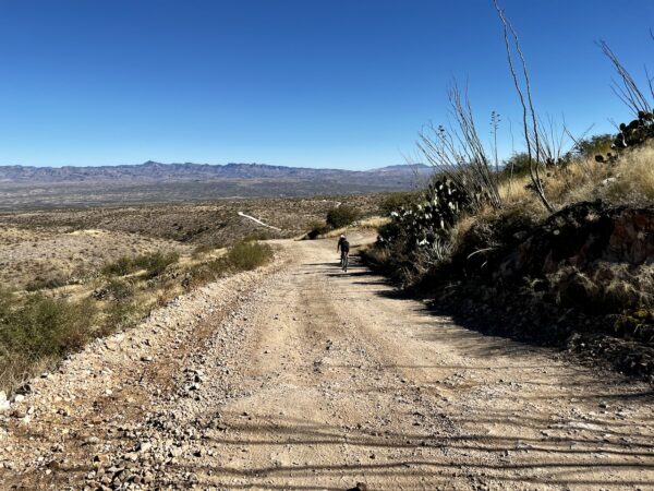
Redington Road began as a rough trail over a natural saddle between the Santa
Catalina and Rincon Mountains. At one point, it was a military road and stagecoach route as more farmers and ranchers settled in the valley. The Pass was once called Cebadilla, but eventually took on the name of the town of Redington which was established in 1879. The Pass was often impassable and fell into disuse until 1932, when funds were raised to finance the reconditioning of the road. Nonetheless, because of its challenging terrain and unpaved condition, Redington Road and its access to the Pass have remained undeveloped. [Friends of Redington Pass]
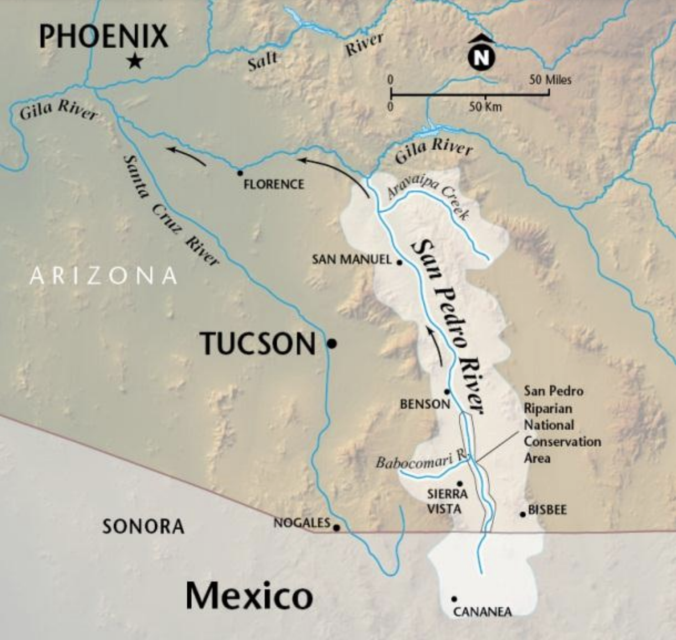
San Pedro River Valley / Miles 14.5 to 16.5
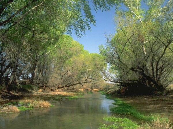
The San Pedro River valley is the most significant migratory flyway remaining in the Southwest. Nearly 400 species spend part of their life cycles along the San Pedro, and during peak migration, between 1 and 4 million birds are found there. Part of the Madrean Sky Island Archipelago, the entire valley’s exceptional species richness has complex causes, but for birds, it provides a well-watered, verdant corridor running from the southern tropics toward northern tundra (and back), with stacks of diverse and accessible vegetation resources rising up alongside it in the form of “Sky Islands” all the way to its confluence with the Gila River. [San Pedro River Valley.org]
A7 Ranch / ~ Miles 5 to 25
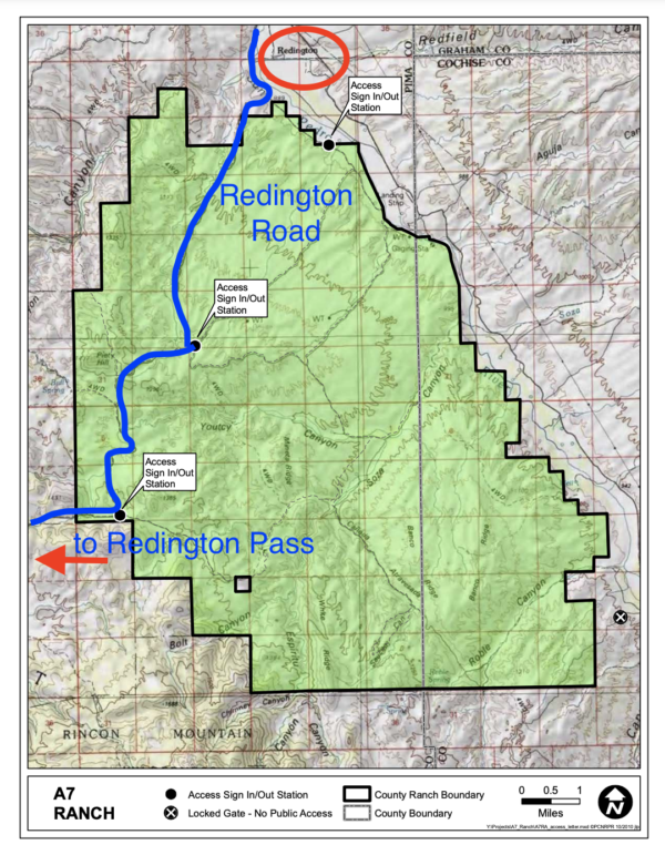
The A-7 Ranch is owned by Pima County – it was purchased with funds from a voter approved 2004 Bond program that made $174 million dollars available for open-space purchases. The A-7 stretches from Buehman Canyon in the Santa Catalina Mountains down to the North East corner of the Rincon Mountains and is bordered on the east by the San Pedro River. The ranchlands provide an important wildlife corridor from the Galiuro Mountains to the Catalina Mountains.
Prior to the City’s purchase, the ranch was part of a larger ranch totaling about 96,000 acres known as the Bellota Ranch. The Forest Service still maintains grazing permits on the lands.
Redington (the town) / ~ Mile 16.5
Redington was a little ranch community founded by two brothers from New York, Henry and Lem Redfield in the year 1875; it eventually became part of a very large ranch in the area. “The town itself was wild and lawless despite its many solid citizens. Old records show that there were more killings there in the late 1800s than in any other community of its size in Southern Arizona. By the mid-1880s, Apaches were no longer a problem, but the drunken cowboys and desperate outlaws were.” The townsite is ~ 2.5 miles northwest of the route at mile 16.5. [Friends of Redington Pass]
Credits & Acknowledgements
A big shout out to GrantA for bringing this route to our attention.
When We Like to Ride This
Non-weekends, fall to spring. We recommend avoiding the route on weekends, as Redington road tends to see quite a bit of use then. The route rides between 3000 and 4500 feet, a bit higher than the Tucson area.
Terrain & Riding
This route is deceptively difficult. Tough and unforgiving sections of gravel/ dirt road. Undulating. Short, steep pitches. A long finishing climb.
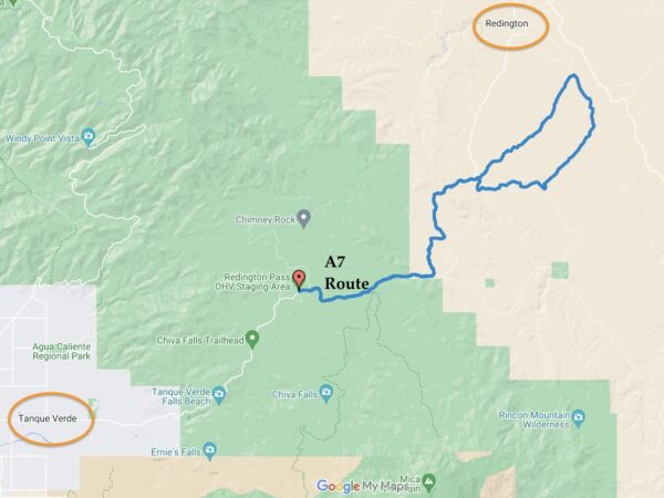
The route starts just east of Redington Pass, on Redington Road at 4200 feet. It is high desert grasslands with the Santa Catalina mountains to the north and the Rincon mountains to the south. Stuningly beautiful! From here, it descends to 2900 feet at mile 16 through the desertscrub of cactus, creosote bush, and mesquite trees.
Redington road (the stick of the lollipop, a descent of 1500 feet with 1000 feet of climbing) is the roughest and most demanding road of the day. It is a dirt road, but it has this embedded granite rock layer that makes the ride jarring and unforgiving (especially if you have too much air in your tires!). Once you leave the stick of the lollipop and are onto the loop it is a gradual descent of 2 to 3% to the San Pedro Valley floor. It is lickety-split fast and fun! Champagne gravel by Walmart.
From the low point of the day, near the A7 Ranch buildings, you have 2000 feet to climb. First on smooth hard-packed road, then 9 miles of the rough and textured Redington road. Here, is where you can begin to feel a bit worked.
This route is best ridden in the direction as mapped, counter-clockwise. There is a section of sand wash at mile 15 that is a whole lot easier pedaling downhill through than uphill.
The Start
Redington Pass OHV parking area. Dirt lot. Pit toilets. The drive to the parking area, from Tanque Verde on the east edge of Tucson, will take ~ 30 to 45 minutes on the rough and bumpy unpaved Redington Road (~ 7 miles)
Food & Water
- None
Route Notes
We have chosen to start this route at the top of Redington Pass, which is ~ 7 miles in from Tanque Verde on the rough and bumpy unpaved Redington Road. This sector of Redington Road sees a lot of use from OHVs, dispersed campers, hikers, and recreational gun use (ie. target shooting) and the road can be heavily washboarded in spots. By starting at the top of the pass, you get a much more remote and quiet experience.
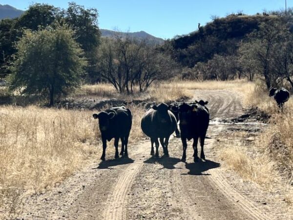
There is open grazing along the route. We recommend taking a look at this resource page on Cows. Learn how to pass by a cow giving you the big stare-down, how to read the signs of aggression and know when to back off. Whooping and hollering are not the right things to do!
Route Options
Soon we will be publishing a complement to this route, A7 Rowdy. It is a Development Route and has not been fully vetted.
Love Where You Ride! Learn More
 Much of the information about the indigenous cultures that lived in the San Pedro Valley (a focus area of this ride) has been lost to time. Many of these cultures did not have a written language, so much of their history and traditions were passed down orally from generation to generation. Additionally, the arrival of European colonizers in the region led to the suppression and loss of many indigenous cultures and traditions. We do know that the valley was a natural corridor in which generations of native peoples lived and traveled for more than 12,000 years, including the Sobaipuri O’odham, Hopi, Zuni, and San Carlos Apache.
Below, we have included a short video about the Sobaipuri people, they occupied southern Arizona and northern Sonora (the Pimería Alta) in the 15th–19th centuries, the time when European explorers arrived including Marcos de Niza and Father Eusebio Kino.
Videos
The Ride! A7
A quick 2-minute video of what to expect on your ride!
The Sobaipuri O’odham People
A 7-minute video exploring the lives and culture of the Sobaipuri O'odham People (i.e., the River People).
Be Informed!
Ridden and Reviewed by:


 Behind every route is scouting, mapping, storytelling, and a whole lot of pedal power.
Have you ridden this route? Got a question? Join the discussion!