Dirty Freehub
Favorites Sign In Search
  • Search
  • Donate
  • Gravel Routes
    • Explore by Region
    • Explore by Type
    • Explore by Collection
  • All Access®
  • Stories
    • Bike Life
    • Culture & History
      • Central Oregon
      • NE Oregon
      • Bend Trails
      • Death Valley
    • People & Places
    • Lands
      • Arizona
      • Central Oregon
      • NE Oregon
    • Love Where You Ride
  • Events
  • User Guide
    • Route Types
    • How We Rate Routes
    • Using the Map
    • Loading a GPX File
    • Glossary
    • FAQs
  • Inside DF
    • The Team
    • Our Missions
    • Impact Reports
    • Press
    • Sponsors
  • Store
    • Gravel Guides
    • Merch
  • Donate
  • Cart
  • Sign In
  • Favorites

Scamander

5 Star Route / St Marys, Tasmania / Published: Nov 2018 / Directions
Save to Favorites Remove from Favorites
History of St. Mary's pass
A bit of history on St. Mary's pass.
Gravel cyclist descending, Tasmania
The beginning of the descent.
Cycling Scamander
A flat spot part way down.
Ocean views on gravel cycling route, tasmania
Views of the ocean to the left.
Whale watching on gravel cycling route
Shelly point - watch the surfers and look for whales.
Scamander river along gravel cycling route, St. Mary's
The Scamander river
Gravel cyclist on flat and straight segment
The gravel road is initially flat and straight.
Climbing gravel roads on tasmania cycling route
After the 4-way junction the road begins to climb.
Cyclist with views of North Sister, tasmania
North Sister in the distance.
Creek crossings, gravel cyclist across bridge
One of several creek crossings.
Ridge views on cycling route
On the ridge with views to the right and left.
Steep climbing, ascending on cycling route
North Sister in the distance again. Just before the steep climbing.
Steep pitches on tasmania cycling route
Expect pitches in excess of 15%.
End of climbing, cyclist finishing climb
Near the end of the climbing for the day.
Cycling route to start/finish
Get ready to descend back to the finish.
*
Route:
Loop | 37 mi
*
Gain:
3,400 ft
*
Surface:
50% gravel, 50% paved
*
Technical Difficulty:
Moderate
*
Navigation:
Straightforward
*
Locale:
Rural
*
Tire Suggestion:
40 mm+
*
Options:
---

Scamander the demander . . . Scamander is the name of a sleepy beach town on the ride. But the only thing sleepy about this mixed gravel ride is the first half of it . . . just you wait for the second half!

Read More
Map
Brown = gravel / dirt road
Blue = single track
Red = paved road
Purple = paved bike path
GPX Download   Version 1.0
Ride Details

When We Like to Ride This

All year.

Terrain & Riding

The ride starts in St Marys and is easy like Sunday morning. You buzz downhill through the St Marys Pass State Reserve. You’ll drop 1,000 feet (305 meters) on the Esk Highway to get to Scamander and then a few miles past you reach the beach. The viewing area has a whale spotting station up the hill and a nice spot to watch the surfers. After a lovely stop, you turn around and head back to Scamandar, to the Upper Scamandar road. The road begins as tarmac but quickly becomes a wide gravel road that hugs the shoulder of the Scamander River.

You will be thinking, “wow, I’m riding strong today. This ride will be over in no time. I’m in such great shape.” But keep those thoughts to yourself because you haven’t even started the ride.

The climbing starts with rollers … sort of like the waves on the beach, they keep hitting you. Steeper and steeper, with nice breaks. You will be sure a dozen times or more that you have reached the top. The gravel can be kind, the gravel can be cruel, so pick your lines carefully. Eventually, you are on the ridge which provides really nice views to the east and west.

From the ridge you make a left turn which offers up the longest and steepest climb of the day. The tsunami. It’s a good 1/2 mile (1 Km) of a plus 15% grade. We saw 17% and 20% on the GPS. When you see the coast line to your left, you are almost to the summit.

With 1000 feet (305 meters) of elevation gain in the bank, you fly down the last few miles … cutting through small farms and large trees.

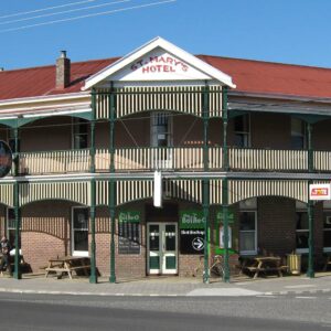
Suddenly you are back at the St Marys’ Hotel and Bar. Right where you started.

The Start

Lat / Long: -41.579701, 148.185513

The city park at St. Marys where A4 forms a “Y”.

Food & Water

  • ~ Mile 10 (Km 16): Scamander
Notes & Options

Route Notes

  1. We recommend a red blinky light with rear looking radar detector (i.e. Garmin Varia)

Comments

Have you ridden this route? Got a question? Join the discussion!

Keep it Local! Learn More

After Ride

St Mary's Hotel & Bistro Tasmania

St Mary’s Hotel and Bistro was built in 1910, a historic Australian hotel.

Ridden and Reviewed by:

KevinE

KevinE / Team Dirty Freehub

He should have “Never Stop Exploring” tattooed on his chest! He loves adventures on bikes and is a Co-Founder of Dirty Freehub.

LindaE (aka Gravel Girl)

LindaE (aka Gravel Girl) / Team Dirty Freehub

She loves a good day of gravel, like most people like a good book. She’s always amused by the outdoors and the wild adventures. Gravel Girl is a Co-Founder of Dirty Freehub.

Sign Up for the Dirty Freehub Newsletter

info@DirtyFreehub.org
Terms of Service Privacy EEO Policy Our Values
Dirty Freehub is 501(c)3 non-profit organization.
©2025 Dirty Freehub :: All Rights Reserved :: Website Design
Cleantalk Pixel

We Need Your Support!

Dirty Freehub is a 501(c)3 nonprofit funded by generous donations from riders like you!

  • $25 Keeps the lights on (web hosting, technology tools, insurance, etc.)
  • $50 Keeps lights on + up to date route conditions
  • $100 Continued route development
  • $200 Fully documented route guide
  • $200+ Gravel Girl giggle of gratitude

Donate Today