Steens Mountain Loop Road


Caution! We do not provide turn-by-turn directions in our GPX files. Those are auto-generated by your bike computer and are usually less than 70% accurate. Learn more.
For help loading a GPX file onto your bike computer, go here.
DownloadWhen We Like to Ride This
This ride is best ridden in the early summer. The road opens usually in early July, so catching it right after it opens is a tremendous idea (to avoid the washboard). This ride offers up little protection from the sun so there’s a great chance of frying on the second half. And given you are climbing up to 9700 feet, you might suffer from hypothermia (the summit is 15 degrees cooler than Frenchglen ) or heat exhaustion in the same day. For more information, see the Notes tab or check with the Burns District BLM Office for road status and conditions.
Terrain & Riding
The ride starts in Frenchglen. The first few miles are an easy warm up, crossing over a bridge and wandering through an open grazing area (a cow pasture is what east coasters call them.)
As you start to climb, you will keep looking up and thinking, “where is the top?” You might even think you are on the wrong road. But if you are headed uphill, keep on going ….
You pass by a few ponds and some trees, but mainly it’s open vistas. Just past Fish Lake campground the ride changes character. The pitches get steeper, the terrain becomes more undulating and scenic.
Eventually the top unfolds and you will wind through open, scrubbed mountain side. Look out for the famous Kiger mustangs, antelope, coyotes, and loads of birds of prey which are doing their job at keeping the chipmunk population down.
The first view point is Kiger Gorge which is an incredible deep canyon running north and south. (1/4 mile out of the way, with a 100 yard walk). The second view point is the East Rim which leaves you feeling like you are standing on top of the world (.5 mile climb that is steep.). And the third viewpoint is from the true summit. It provides a fantastic view of Wildhorse Lake and the Alvord Desert. (2.5 miles and super steep, but with the best views!!)
Once you are done playing tourist, the fun just begins. Give your brakes one final check and continue on the Steens Mountains Loop Road. In ten miles you will drop 4,100 feet. It doesn’t take a math major to figure out that’s a tough descent on gravel roads. You will be squeezing the brakes.
At the bottom, you need to find your second wind. You roll along open dry forest mixed with more open grazing areas. A few short popper hills will wake up your legs until you intersect Highway 205 which is the first paved road since you left. From there, you have ten miles back to French Glen. Which eight of those are a slight uphill for which (fingers crossed) you have a tailwind. And then … a blissful winding downhill that will help you forget the last 8 miles and have you giggling like a school girl.
Then you can pop into the French Glen hotel for a snack or a well deserved beer.
Loop Road History. The Loop road had its beginnings in 1930 when the Civilian Conservation Corps built a road from Frenchglen up to Fish Lake. The onset of World War II delayed plans for the construction of the remaining portion of the road until the 1960s. The road was completed in 1962 and has received regular maintenance and the occasional upgrade ever since. [BLM Oregon & Washington Facebook Page]
The Start
Food & Water
- Mile 16.5 Fish Lake campground
- Mile 18.5 Jackman Park campground
- Mile 43 South Steen’s campground
Route Notes
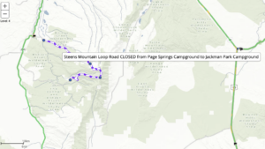 To check if the road is open, go to TripCheck.com and magnify the area just south and east of Frenchglen. You will find the closed sections of the Steens Mountain Loop road as a purple and white dashed line (see example just to the right). The open sections will appear without any color or shading. The Steens Mountain Loop road is Oregon’s highest elevation road and is generally open from early July to November. Portions of the Loop road are closed gradually in the winter. Sections are re-opened in the spring depending on snow levels and moisture conditions in the area.
Cell coverage is shockingly good on the front side for some carriers (we were posting Facebook pictures at the top) but suddenly falls apart on the backside. Even the last ten miles of paved road was crickets.
While this is the largest fault block mountain in North America, there’s not enough traffic on the backside to plan that someone is going to rescue you if it all goes to shit.
Route Options
This route is also included in our 5-day bikepacking / touring route of the Steens Mountain.
Ridden and Reviewed by:


 Behind every route is scouting, mapping, storytelling, and a whole lot of pedal power.
Have you ridden this route? Got a question? Join the discussion!