Skidoo


Caution! We do not provide turn-by-turn directions in our GPX files. Those are auto-generated by your bike computer and are usually less than 70% accurate. Learn more.
For help loading a GPX file onto your bike computer, go here.
DownloadHighlights & Remarkable Spots
The Emigrant Climb / Miles 0 to 10 / Paved
9 miles of paved road that gains 2500 feet. The gradient is about 5% the entire way. You are bounded by short canyon walls that are sometimes close in and at other times a quarter of a mile to your left and right.
At mile 6.8 take the right turn, a short side trip, to Journigan’s Mill.
Roy Journigan acquired this mill site in Emigrant Canyon shortly after the passage of the 1934 Gold Reserve Act caused the price of gold to jump from $25 to $35 per ounce. His strategy was to operate a custom mill for local mines, so both he and the mine owners would profit by hauling higher-grade ore to smelters, thus cutting transportation costs. By acquiring water rights to four local springs to the southwest and piping water to the mill, he increased the mill’s capacity and his profit margin. In 1939 Journigan sold the mill, which continued to operate under several different owners until the late 1960s. [National Park Service Kiosk]
Skidoo Road Outbound / Miles 10 to 19 / Gravel
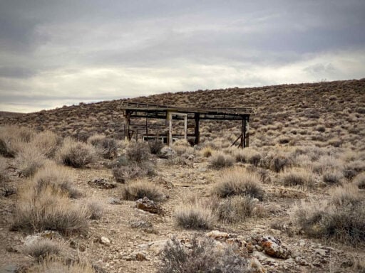
The first several miles of Skidoo road is through open and expansive terrain at a slight gradient. As the road pitches up, the hillsides sneak in on you. Keep an eye out for old mining sites and buildings. You can usually explore these areas by taking the off-shoot road from Skidoo road. We wandered out to many of these sites. After visiting several, you being to wonder where the miners found water, got food from, and how they brought lumber in, and from where.
Almost unexpectedly you find yourself on a pseudo-ridge looking back east towards basins of Death Valley and Furnace Creek, nearly 6000 feet below you. In the distance, you can see mountain ranges lined up behind each other. This portion of the ride makes the entire effort worth it.
Continue higher and back into the desert flats and you soon come to a dirt pullout with the National Park Service kiosk documenting the history of Skidoo. From here, explore! The route includes a short loop to several of the mine entrances and to abandoned equipment. Make sure you plan in time for this part of the adventure!
The Return / Miles 19 to 36 / Gravel to Paved
The gravel sector will feel a bit more rugged going out than coming in due to the extra speed. The ridge riding is still special. And the paved descent is so fun, no pedaling needed!
When We Like to Ride This
October to April, when the temperatures are reasonable. Note, the route starts at 2000 feet and climbs to 5800 feet. Be aware that temps at Skidoo could be 15 to 20 degrees cooler than Furnace Creek. Temperatures drop 3 to 5°F (2 to 3°C) with every thousand vertical feet gained(approx. 300m).
Terrain & Riding
Rugged desert terrain. Significant climbing. A few miles of ridge riding with explosive views. And the chance to explore the old mining area of Skidoo.
The Start
At the intersection of Emigrant Road and State Highway 190. There is a National park service kiosk with parking and flush toilets. No potable water.
Food & Water
- None.
Route Notes
We recommend checking the National Park Service’s road conditions page before your ride. Many roads in Death Valley National Park have been affected by weather and flooding in recent years.
Death Valley is classic Southwest desert riding with more of a jeep road feel than a classic gravel road; it can vary from hard-pack with embedded rock to loose and course to soft wash sand and washboard. The surfaces are ever changing based on based on maintenance, rains, and time of year. Thus, error on the side of too much tire, rather than not enough. We Recommend 50 mm (2.1”) tires or larger and an adventure gravel bike versus a more traditional all road gravel bike.
We recommend a red blinky light for the paved sector.
The ride starts at 2000 feet of elevation and climbs to 6000 feet, be prepared for cooler temps. We used our windbreakers on the descent, a day when it was 83 degrees in Furnace Creek.
Check the weather before you go. The area can get windy! This ride is exposed to both wind and sun.
Love Where You Ride! Learn More
 We love our national parks. In this article, the National Parks Foundation outlines 6 ways to support our National Parks. Take a few minutes to give it a read. Then, get involved!
Videos
The Ride! Skidoo
A quick 2-minute video of what to expect on your ride!
Ridden and Reviewed by:


 Behind every route is scouting, mapping, storytelling, and a whole lot of pedal power.
Have you ridden this route? Got a question? Join the discussion!