Ruby North
The ghost town of Ruby is now closed to public access as of June 2024. The ride as documented still “goes”.


Caution! We do not provide turn-by-turn directions in our GPX files. Those are auto-generated by your bike computer and are usually less than 70% accurate. Learn more.
For help loading a GPX file onto your bike computer, go here.
DownloadHighlights & Remarkable Spots
The Ghost Town of Ruby / ~ Mile 15
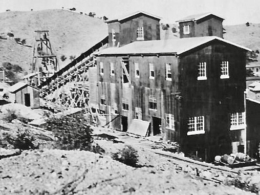
The first Europeans to visit the Ruby area were Spanish conquistadors in the late 1500s. In the 19th century, the region was referred to as “Oro Blanco,” or white gold, after a distinctive light-colored strain. Later, as colonists moved west, there was an influx of adventurers, mountain men, ranchers and miners. The first strike in the Montana’s vein was in the late 1870s, and by the turn of the century, the town of Ruby had become the largest mining camp in the area. Ruby was once the largest lead and zinc producing mine in the state of Arizona.
Mexican Free Tail Bats / ~ Mile 15
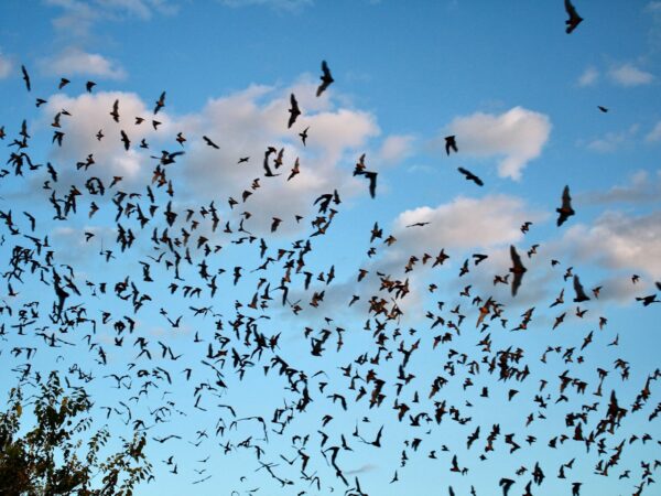
A colony of Mexican Free Tail Bats inhabits Ruby’s abandoned mine shafts from May to September each year. Estimates of the colony range from 90,000 to as high as 150,000 animals, representing a nightly appetite for up to a 1/2 ton of insects. This is considered a maternal colony, and they produce their young in June and leave for parts south in late August. Contact the caretaker at Ruby to make arrangements to see this sight.
When We Like to Ride This
Late fall to early spring when the skies are clear and the temps are moderate. We would avoid this route in summer as the section along the stick of the lollipop is very exposed to the sun. Wind could also make this route brutal. And … if it has recently rained, give it several days to let the washes run shallower or dry.
Terrain & Riding
Word of Caution: if being remote scares you in the least, skip this ride. The only vehicles we saw (2) were local, friendly Border Control. Which also means you REALLY need to have your navigation figured out and having a SPOT or inReach device (you know, the kind that lets you dial 911 via satellite messaging) isn’t such a bad idea either.
The ride is a stick with a loop (i.e. lollipop) and the option of a visit to the host town of ruby. The first 5 miles are “Arizona paved” which is anybody’s guess if you will hit a pothole. Then it’s a wide gravel road that passes by small farms that slowly trends upwards. At the edges its fast riding, but in the center its numbing gravel cobblestone, that slowly trends upward. At mile 8, you may encounter two friendly dogs with tags that state “Don’t feed me.” Just before mile 10 you enter Oro Blanco wash where the real fun begins.
This is near the start of the loop and the rugged factor triples. Soon you are navigating through canyons (Warsaw Canyon and Colorado Gulch. Popping up and down punchy hills of 10% +. The surface can be loose and gnarly. It is technical riding. But … so worth it!
The views seem to get greener, livelier as you head out along the loop, until you are just damn impressed. A few times, you will be on a ridgeline which provides the dreamy views of Oz that you were hoping for. As your heading north, the Atascosa Mountains will be directly in front of you. Bartolo Mountain to the left and Atascosa Peak to the right.
Just before mile 23, you finish up the loop. Now’s the time to decide if you are going out to the ghost town of Ruby. (You need to check their feed on Facebook to make sure they are open and what they are charging.) It adds just a few miles and about an additional 300 feet of climbing. We no longer recommend the dog-leg out to Ruby, it was closed to public access in June 2024.
After you visit Ruby, head back towards Arivaca on the road that you came out on. Off in the distance, look out for Baboquivari peak. It’s the obvious peak. The road back has a nice buzz to town, but still with enough roughness to make you work for it.
Save a smidge of energy to enjoy Arivaca. It’s a funky little town with a market and enough history and grit to be entertaining. You might also walk through the Buenos Aires picnic area when you are through; it’s quite the popular spot for birders.
The Start
Buenos Aires National Wildlife Refuge (Arivaca Cienega). Pit toilets.
Food & Water
- None.
Route Notes
This route has a completely different character than Ruby (South). Ruby (South) is tucked up alongside the Atascosa Mountains and has wide, sweeping views for most of the day. Ruby (North), this route, is much more of an exploration of washes, canyons, and gulches. We strongly recommend both routes. And … if you’re into “big”, give Big Ruby a go. It takes in the best of both routes.
40 mm tires are about the minimum for this route. 650b’s with 50 mm or a 29’er with 2.1’s would be our preferred choice.
Regarding Border Patrol. When we come across them for the first time in the day, we stopped and asked if “there’s anything we should be aware of” and we also gave them our route for the day. Border Patrol was professional, helpful and polite.
Love Where You Ride! Learn More
This ride entirely within the Atascosa Highlands COA (Conservation Opportunity Area). These region has been identified by Arizona Game & Fish for its significant ecological value, where targeted conservation efforts can effectively preserve and enhance biodiversity. The Atascosa Highlands COA encompasses three mountain ranges—Tumacacori, Atascosa, and Pajarito—located just west of Nogales, Arizona.
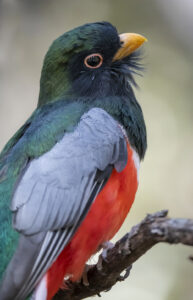
Within the COA are Sycamore Canyon and California Gulch. Sycamore Canyon boasts up to 95 breeding bird species, one of the highest breeding bird diversity concentrations in Arizona. California Gulch is unique with quality thornscrub habitat, a dense shrub layer on its steep sides, and a perennial spring-fed stream. Both canyons support several Mexican species that are rare in the United States, such as elegant trogon and Rivoli’s hummingbird. This area is also an important dispersal area for Mexican breeding populations of jaguar.
We ask that you treat this area with the utmost respect: tread lightly and watch from a distance!
Ridden and Reviewed by:


 Behind every route is scouting, mapping, storytelling, and a whole lot of pedal power.
Have you ridden this route? Got a question? Join the discussion!