Dirty Freehub
Favorites Sign In Search
  • Search
  • Donate
  • Gravel Routes
    • Explore by Region
    • Explore by Type
    • Explore by Collection
  • All Access®
  • Stories
    • Bike Life
    • Culture & History
      • Central Oregon
      • NE Oregon
      • Bend Trails
      • Death Valley
    • People & Places
    • Lands
      • Arizona
      • Central Oregon
      • NE Oregon
    • Love Where You Ride
  • Events
  • User Guide
    • Route Types
    • How We Rate Routes
    • Using the Map
    • Loading a GPX File
    • Glossary
    • FAQs
  • Inside DF
    • The Team
    • Our Missions
    • Impact Reports
    • Press
    • Sponsors
  • Store
    • Gravel Guides
    • Merch
  • Donate
  • Cart
  • Sign In
  • Favorites

Montezuma

5 Star Route / Tucson, Arizona / Published: Dec 2019 / Directions
Save to Favorites Remove from Favorites
*
Route:
Out & Back | 36 mi
*
Gain:
4,300 ft
*
Surface:
93% gravel, 7% paved
*
Technical Difficulty:
Moderate
*
Navigation:
Straightforward
*
Locale:
Urban Backcountry
*
Tire Suggestion:
50 mm+
*
Options:
---

Francisco Vázquez de Coronado might have been a failed Spanish explorer during the 1540’s, but inspiring the Coronado National Memorial is quite the legacy which is where this route starts. The route climbs up the majestic Montezuma Pass, dives off the back …. then sweeps down across open grasslands in the San Rafael Valley. Three popper hills later (we call them the teeth) and you arrive at Parker Canyon lake, where you can enjoy a nice picnic stop before returning on the same roads, but in reverse. The “teeth”, the grasslands, and up and over Montezuma Pass. The final few miles, descending back into the visitor center, is just spectacular!

—

We have ridden this entire route, and it is wonderful! However, we have yet to secure the funding and resources to document the ride fully (you can help by donating!), thus the limited information. If you give the route a go, please leave us a comment about your experiences.

Read More
Map
Brown = gravel / dirt road
Blue = single track
Red = paved road
Purple = paved bike path
GPX Download   Version 1.0
Ride Details

When We Like to Ride This

Late fall to early spring when the skies are clear and the temps are moderate. We would avoid this route in summer. It is very exposed to the sun. Wind could also make this route brutal.

Terrain & Riding

The first 3 miles wastes no time with a solid 1,300 foot climb to the top of the pass. The first mile is paved and then changes into gravel switchbacks with dreamy views of the surrounding area. When you reach the towers, stop and really suck in that glorious view.

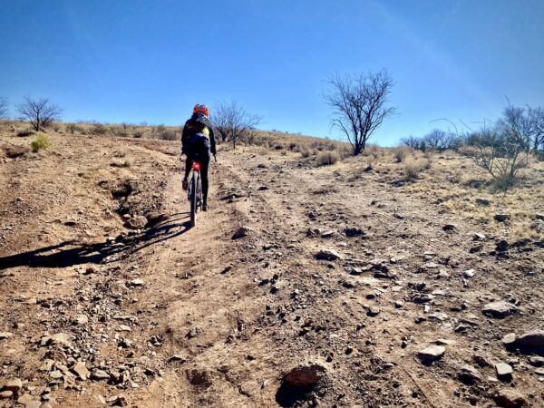
Then “dive off” the back of the pass for a few miles (6% grade), which then levels off to a nice flowy downhill. The area is littered with Pinyon pines and Junipers that perfectly frame open vista views of the San Rafael valley.

At ~ mile 11.5, the low point of the day, there are several creek crossings — Sycamore Creek and Joaquin creek. For us in December, a few days after several days of rain, the creeks were flowing with water.

Soon enough you end up on a straight road through grasslands that host curious cows and climbs gradually. Now for the teeth, pitched rollers that take you out to Parker Canyon lake. The closer you get to the lake the more rugged the road becomes, something we like to call gravel cobblestone.

There’s a seasonal store at the lake (see below) that rents canoes and supports the fishing community, but don’t bet the ranch on it being open or providing you with water. At the lake you have done half the elevation and you are halfway home! Just turn around and head back the way your came out … and save a bit for that last 1.5 miles to the top of Montezuma Pass.

The Start

Lat / Long: 31.344933, -110.255169

Park at the Coronado National Memorial Visitor Center. Pop in and say “howdy” to the friendly staff before taking off. Flush toilets, water.

Food & Water

  • Parker Canyon Lake and Marina general store. Seasonal.
Notes & Options

Route Notes

  1. Riding in the desert southwest is often very different from riding in Colorado or Oregon, with terrain that is noticeably more rugged and challenging. For tips and advice, check out our Resource Page: Riding in the Desert Southwest.

  2. The area is actively patrolled by Border Patrol. As a general practice, when we encounter Border Patrol for the first time each day, we stop to check in with them. We ask “if there’s anything we should be aware of”. While they cannot tell you directly about ongoing operations, they may provide subtle hints if it’s not an ideal day to ride. If so, leave your ride for another day. Additionally, we share our planned route with them and request that they pass this information along to other agents who may be in the area.

Comments

Have you ridden this route? Got a question? Join the discussion!

Help Make this Guide Better!

At Dirty Freehub, we believe the best routes are organic and driven by the riding community. This ride guide is still a work in progress, and we need your help to make it better!

What you can do:

  • Let us know about points of interest and viewpoints.
  • Submit pictures and videos.
  • Suggest a best time to ride.
  • And tell us about your favorite place to go after the ride for a burger and beer.

Please submit your feedback via the comments block (see the tabs just above map).

Thanks!
Team Dirty Freehub

Be Informed!

Rocky Riding in Desert

Riding in the Desert Southwest

Gravel riding in the desert southwest is unlike anywhere else in the US! It is rugged and demanding with ever changing conditions. You should expect sandy washes, sometimes for miles; you should expect washed-out trail from the heavy summer monsoon rains, and you should expect rocky and gnarly. One year, the riding is great; the next, it is not.

Read More »

Ridden and Reviewed by:

KevinE

KevinE / Team Dirty Freehub

He should have “Never Stop Exploring” tattooed on his chest! He loves adventures on bikes and is a Co-Founder of Dirty Freehub.

LindaE (aka Gravel Girl)

LindaE (aka Gravel Girl) / Team Dirty Freehub

She loves a good day of gravel, like most people like a good book. She’s always amused by the outdoors and the wild adventures. Gravel Girl is a Co-Founder of Dirty Freehub.

Explore Similar Routes:

Bird Watching

Sign Up for the Dirty Freehub Newsletter

info@DirtyFreehub.org
Terms of Service Privacy EEO Policy Our Values
Dirty Freehub is 501(c)3 non-profit organization.
©2025 Dirty Freehub :: All Rights Reserved :: Website Design
Cleantalk Pixel

We Need Your Support!

Dirty Freehub is a 501(c)3 nonprofit funded by generous donations from riders like you!

  • $25 Keeps the lights on (web hosting, technology tools, insurance, etc.)
  • $50 Keeps lights on + up to date route conditions
  • $100 Continued route development
  • $200 Fully documented route guide
  • $200+ Gravel Girl giggle of gratitude

Donate Today