Bud and Bo


Caution! We do not provide turn-by-turn directions in our GPX files. Those are auto-generated by your bike computer and are usually less than 70% accurate. Learn more.
For help loading a GPX file onto your bike computer, go here.
DownloadWhen We Like to Ride This
Fall to spring when the skies are clear and the temps are moderate. We would avoid this route in summer as it is very exposed to the sun. Wind could also make this route brutal. And … if it has recently rained, give it several days to let the roads dry, they are of a clay base and can turn into super sticky mud.
Terrain & Riding
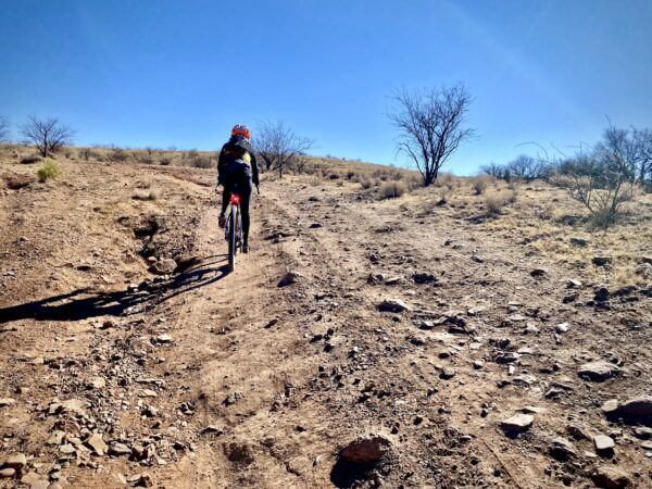
The route is 44 miles of an awesome mixture of gravel and paved roads. You start in the (ghost) town of Canelo, heading down a dirt road scattered with houses. Soon the hills, the Canelos Hills, transition to the solitude of Pinyon-Juniper woodlands. The initial climb is just steep enough to have you worrying that the day is going to be a slow one. The surface is gravel cobblestone, but you can find smoother riding at the edges of the road.
At ~ mile 4, you start sweeping down and down, out to the open winding grasslands of the San Rafael Valley. Occasional (and we do mean occasional) ranches come in and out of focus. And occasional willow trees offer up a nice foreground to a continuous view of sweeping mountain ranges. Loose range cattle will sometimes play in the road, but with a few good YEAHAWS they are off and running.
The route runs north to south through the heart of San Rafael Valley crossing the Santa Cruz river several times. The valley is the headwaters source for the Santa Cruz river. At ~ mile 19.5, very near the Mexico border, the route turns northeast and begins to undulate upward. Soon it is a steady incline of 1 to 2%. At mile 25, on Sunnyside road, the grade is consistent 3%. Look to your right and just to the right of Lone Mountain and you can see the dirt road that climbs up to Montezuma Pass. Not to be had today, but put it on your bucket list.
Just before mile 29, to your right you will see signal towers and some mechanical stuff with a small road leading into the site that crosses over a cattle guard. To the right of the tower you will find a memorial to Bud and Bo, two slain Border Patrol agents.
Bud and Bo were shot and killed by Mexican drug runners in 1975. Bud (Louis Davis Dixon) was 32 with a wife and three small children. Bo (Charles Bokinskie) was 26 and engaged to be married. Friends and colleagues of the two heroes wanted to build a memorial to Bud and Bo, but that’s not permitted on public lands. Finally, after 45 years, a memorial has been placed in their honor. Not at the exact place where they were murdered, but this offers up a place for us to pause and remember them, to thank them for their ultimate sacrifice of service.
At mile 30, take a hard left turn toward Parker Canyon Lake where you’ll encounter a few short pitched, steep and rocky climbs. Soon enough, you will see the lake, way below you. When you reach the pavement, the road is rolling, narrow and closed in with lovely pines. Your work for the day is almost done, but not quite yet, there is still 500 more feet of climbing. At the pavement, we recommend putting a bit more air into your tires as it will make the last 13 miles much more enjoyable. (At the junction with the paved road, Highway 83, you can go left and down to the lake and a seasonal store. This adds approximately 1 mile round trip.)
When the road widens out at mile 36, it becomes ripe with distant views. From here the riding is easy and fast with little to no traffic. Roll back into Canelo and then go drop some coin at the local brew pub, Copper Brothel Brewery, or the General Store & Deli in Sonoita.
The Start
A dirt pull out on the west side of the road, Highway 83, just before a left hand 90 degree bend.
Food & Water
- ~ Mile 32: Parker Canyon Lake and Marina general store. Seasonal. At the juncture with Highway 83 go left towards the lake. Slight detour.
Route Notes
45 mm tires work really well (or at least did) on this route. If you catch the conditions when good this route is hard packed and fast. With ~ 14 miles of paved, this is one of the faster riding routes in the Patagonia/Sonoita area.
However, the San Rafael Valley has seen more and more use over time, thus the road conditions have become more washboarded over time. Please see the comments for the latest from riders, and if you do ride this route, leave a condition update in the Comments block.
Lastly, riding in the Desert Southwest is more rugged and demanding than many other areas in the Western United States. For more information on this see our Riding in the Desert Southwest page.
This route comes very close to the border with Mexico and parts of the route are actively patrolled by Border Patrol. As a general rule, when we come across Border Patrol for the first time in the day, we stop and ask if “there’s anything we should be aware of” and we also give them our route for the day.
We recommend a red blinky light with rear looking radar detector (i.e. Garmin Varia)
Route Options
If you’re looking for a longer ride, that includes all of this and more (72 miles, 6700 feet of gain), check out Montezuma el Grande. It is the combination of two 5 Star rides, this one and Montezuma.
Videos
The Ride! Bud & Bo
A quick 2-minute video of what to expect on your ride!
Be Informed!
Ridden and Reviewed by:


 Behind every route is scouting, mapping, storytelling, and a whole lot of pedal power.
Have you ridden this route? Got a question? Join the discussion!