Ajo Air Force Station (aka: Golf Ball)
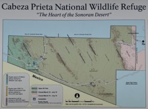
Permit required! Closed March 15 to July 15. See details in Notes & Options tab.


Caution! We do not provide turn-by-turn directions in our GPX files. Those are auto-generated by your bike computer and are usually less than 70% accurate. Learn more.
For help loading a GPX file onto your bike computer, go here.
DownloadWhen We Like to Ride This
Fall through spring. Summer could be hot and exposed.
Please note, a special use permit may is required to bike beyond the gate at ~ mile 3. The permit is issued by the Cabeza Prieta NWR headquarters and normally takes 48 hours to process. Contact Alfredo Soto (Wildlife Refuge Specialist) at (520) 387-4987. Mention that you want to ride the Childs Mountain route posted on Dirty Freehub.
Terrain & Riding
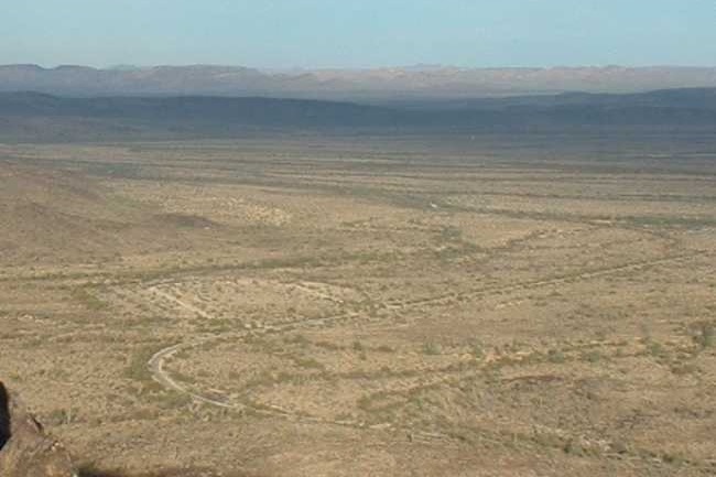
“Childs Mountain, located almost 1,500 feet above the desert floor (2,800 feet above sea level), offers a panoramic view of the surrounding Sonoran Desert, including parts of Cabeza Prieta National Wildlife Refuge (to the west) and the Barry M. Goldwater Air Force Range (to the north). Childs Mountain is an uplifted, old lava flow. The substrate on the mountain is composed of shallow, clay silts and
caliche nodules can be noted.”[Cabeza Prieta Natural History Museum]
From the start, head west on a gravel road across the desert plain. The first 2.5 miles are relatively flat. Along the way [~ mile 2.3], you pass by the old barracks site of the defunct Ajo Air Force station.
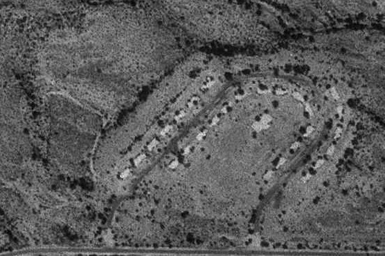
The original barracks site. (Photo Credit: Cabeza Prieta Natural History Association)
The site today. (Photo Credit: Cabeza Prieta Natural History Association)
The Childs Mountain radar station was established in January 1958 and became operational in 1958 as Ajo Air Force Station manned by the 612th AC&W Squadron. The station initially had both a Ground-Control Intercept (GCI) and early warning mission. The early warning mission involved tracking and identifying all aircraft entering their airspace, while the GCI mission involved guiding Air Force interceptors to any identified enemy aircraft. Controllers at the station vectored fighter aircraft at the correct course and speed to intercept enemy aircraft using voice commands via ground-to-air radio.
Abandoned as an Air Force Station 1969 and left to the elements. The station’s 27 housing units were removed to Gila Bend. In 1994 most of the remaining site buildings were torn down, and the site was restored to a natural state by the National Park Service. Only the FPS-26 radar tower remained with the Air Force and FAA maintaining some equipment supporting the Luke-Williams range and radio relay equipment. The upper site was taken over by the FAA in 2000 as a Joint Use radar site and currently has an ARSR-4 3D radar installed. [FortWiki]
The road then bends south and starts up a moderate grade, then makes a long bend north again, at the base of the day’s first steep slope, ~ 6% grade. The road is gated here, at about mile 3.3. The next 2 miles climb 600 feet.
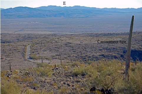
At mile 5.4, you come to a flat respite in the climb. The middle section was the cantonment for 100 to 200 troops stationed at the radar installation. It included administrative buildings, dormitories, a post exchange, a gymnasium, and even a swimming pool. The buildings, including the concrete slabs, have been removed. Thus, leaving little visible evidence of the old base.
The route continues to climb for 0.6 miles until a Y junction. The left fork (south) leads to the current day FAA white-domed radar [paved, 0.7 miles, and 300 feet of gain], which is worth taking a peek at. The right leads out to Larue Benchmark [gravel, 1.3 miles, 300 feet of gain], where there are some interpretive signs and great views!
“I looked out west across the desert at the Growler Mountains and miles and miles of open Sonoran Desert. The views were wonderful. I looked east and all the ranges that way — Sauceda, Batamote, Pozo Redondo, and those surrounding Ajo the town. I could see the spire of Kino Peak way off to the south and the rounded hump of Woolsey Peak north by Gila Bend.” Scott Surgent.
After enjoying the views, turn around and zip back to the start. Now, the most important part. Go visit the town of Ajo! For a bite to eat, visit the Town Plaza. Or maybe wander up to the old mining facility overlook. Or walk the town looking at the mural art.
The Start
A makeshift dirt parking area along the north side of the road to Childs Mountain.
Food & Water
- None.
Route Notes
 You must obtain a permit for this ride. Each person in your party must have a permit AND you must electronically sign in and out each time you access the the Air Force Test Range lands and Cebeza Prieta Wildlife Refuge. Trust us, we have been stopped several times and asked for our permit!
For logging in and out (on-line) this area is known as the Ajo Air Force Station.
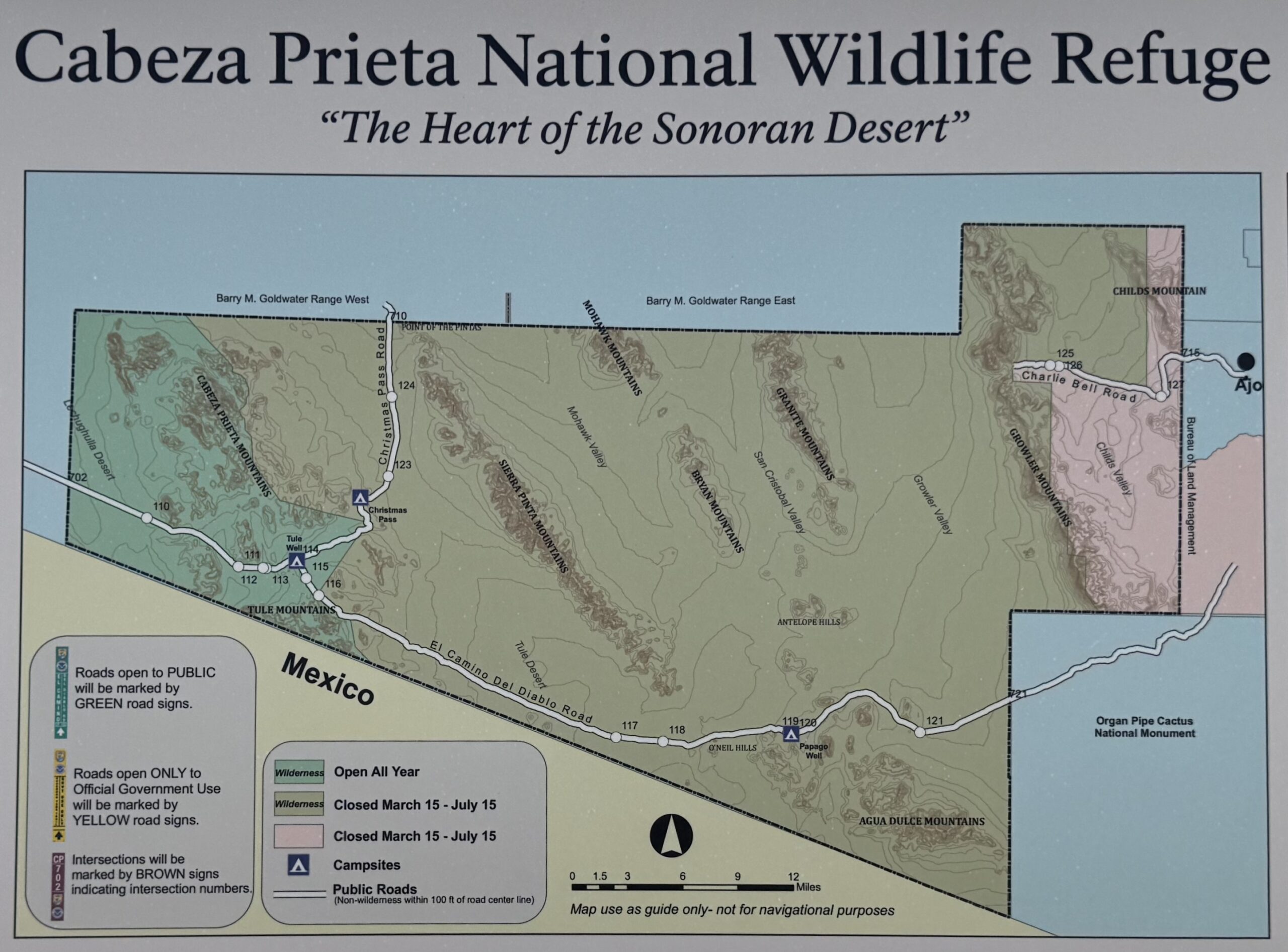
This area of the Cabeza Prieta National Wildlife Refuge is closed March 15 to July 15 for Sonoran Pronghorn fawning. Learn more about this endangered animal in our podcast.Click on image to see exact closure area.
Ridden and Reviewed by:


 Behind every route is scouting, mapping, storytelling, and a whole lot of pedal power.
Have you ridden this route? Got a question? Join the discussion!