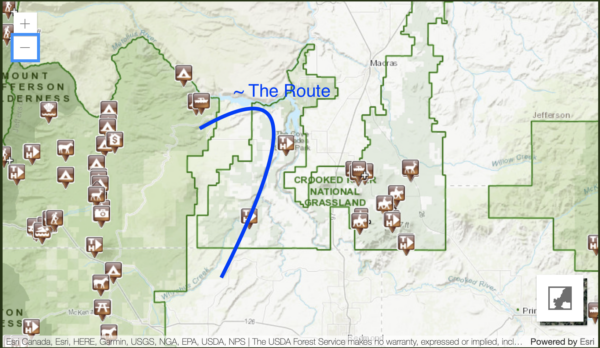
Billy’s Playground
Closed: Due to the Flat Fire of August 2025. Sectors heavily burned.


Caution! We do not provide turn-by-turn directions in our GPX files. Those are auto-generated by your bike computer and are usually less than 70% accurate. Learn more.
For help loading a GPX file onto your bike computer, go here.
DownloadHighlights & Remarkable Spots
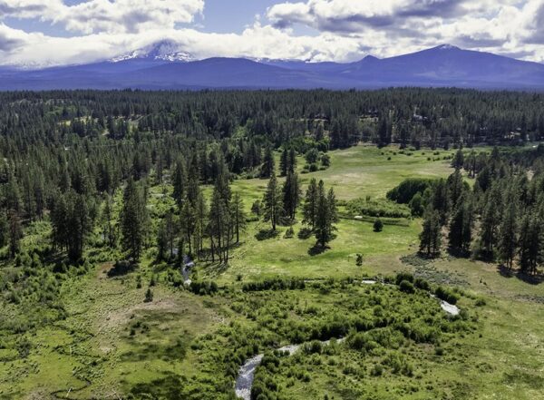
Lake Billy Chinook / @Start
Lake Billy Chinook was created in the early to mid 1960s when Round Butte Dam was built to generate hydroelectric power. The dam impounded the Crooked, Deschutes, and Metolius rivers, flooding their lower canyons and forming today’s reservoir. This dramatically changed fish migration and the river ecosystem. Today, restoration work—including advanced fish passage systems—aims to reconnect these rivers and support native fish runs while still producing power.
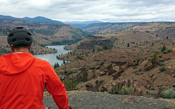
Basalt Cliffs / ~ Miles 0 to 6.5
The basalt cliffs surrounding Lake Billy Chinook are some of the most striking and geologically informative in Central Oregon. They are primarily made of Columbia River Basalt Group lava flows (click on the map for an expanded view), erupted between roughly 17 and 6 million years ago, when vast sheets of molten lava poured across the region and filled ancient valleys.
The cliffs also tell a story of erosion. Before the dams, the Deschutes, Crooked, and Metolius rivers carved deep canyons through these lava layers, exploiting weaker flow boundaries and fractures. When Round Butte Dam flooded the canyons, the lower cliff faces disappeared underwater, leaving today’s dramatic walls that plunge directly into the lake.
Crooked River Crossing / ~ Mile 2
Here, the Crooked River slices through thick basalt layers formed by massive lava flows millions of years ago. The canyon walls reveal stacked flows like a layer cake, offering a clear window into Central Oregon’s volcanic past. The river is also nationally known for its dense population of wild rainbow trout. Although Bowman Dam upstream and Round Butte Dam downstream have changed the river’s natural flow, temperature, and fish migration, the Crooked still supports thriving aquatic life and is a focus of ongoing restoration efforts.
Deschutes River Crossing / ~ Mile 5
The Deschutes River is a major tributary of the Columbia River and drains a large portion of the east-side Cascades, making it central to Central Oregon’s ecology and water story. During the fur-trade era, French explorers called it Rivière des Chutes or Rivière aux Chutes—“River of the Falls.” Today, the river is also a working water source: in the upper basin, irrigation canals divert much of its flow to farmland, with irrigation districts taking nearly 98% of the river’s summer flow.
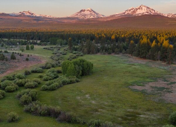
View of Mt Jefferson / ~ Mile 13
Mt Jefferson is Oregon’s 2nd-highest mountain (10,497 ft) after Mt. Hood, but it has a far more rugged and remote-feeling. It’s also one of the most eroded stratovolcanoes in Oregon. Glaciers and time have chewed it into a sharp, craggy, “horned” shaped mountain that looks more like a fortress than a smooth cone. (A stratovolcano is a tall, steep-sided volcano built from many layered eruptions, stacking lava flows, ash, and rock into a single mountain over thousands of years.) Mt Jefferson has dozens of snow-and-ice features, including multiple named glaciers (like Whitewater and Jefferson Park).
View of Metolius Arm of Lake Billy Chinook / ~ Mile 17
From this viewpoint, you see the Metolius Arm of Lake Billy Chinook.
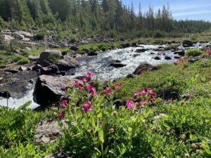
The Metolius River, a National Wild and Scenic River, is one of the largest spring-fed rivers in the U.S. at 29 miles. Its headwaters are powered by massive underground springs, where the river “pops out of the ground” near Camp Sherman (the Metolius Headwaters). Because of its spring-fed source, the Metolius stays consistently cold at about 48°F year-round.
This area is a bull trout success story. After rebounding from extremely low numbers, the bull trout population has become one of the strongest and most robust in the country. Lake Billy Chinook is also one of the only places where you can legally retain a bull trout.
Bull trout are true cold-water specialists, requiring very cold, clean, well-oxygenated water, making them an important indicator species for overall ecosystem health. Despite the name, bull trout are actually a char, closely related to Dolly Varden and lake trout. They’re powerful, top-level predators that can grow very large.
METOLIUS BALANCING ROCKS / ~ MILE 17 (OFF ROUTE ~0.5 MI)
In 2002, a forest fire exposed a geologic wonder with a stunning vista as its backdrop. Heading a fraction of a mile off-route here, you can enjoy the sight of stacked rocks defying gravity, with the Metolius River and Mt Jefferson behind. The rocks are the result of layers of volcanic tuff sandwiched atop one another, eroding at different rates. It’s worth the slight addition of mileage, we promise!
View of BLACK BUTTE / ~ MILE 34
A Warm Springs Indian legend describes Oregon and Washington’s mountains as people who were marching toward the Columbia to take sides in a battle between Mt Adams and Mt Hood. Black Butte and her husband, Green Ridge, joined the march. But along the way, Black Butte became tired in the heat, so she sat down to rest, sweating rivulets that would become the Metolius River. Coyote, the mediator, prevented war by destroying a bridge across the Columbia, and everyone halted in place, where the mountains stand today. [This story is from one of three “Indian legends” under the title “The Peaks of Central Oregon” (Clark 1953: 12-13)]
View of Black Crater / ~ Mile 41
From here, you have a great view of Black Crater in the distance. Despite its name, Black Crater isn’t a typical “cratered” cinder cone—it’s a shield volcano, broad and gently sloped. The feature that looks like a crater was largely formed by glacial erosion, which carved a large cirque into its northeast side. Black Crater rises to about 7,250 feet and hasn’t erupted for roughly 50,000 years.
INDIAN FORD MEADOW PRESERVE / ~ MILE 49
Indian Ford Meadow Preserve was protected in 1996, when a local landowner donated the meadow to preserve its scenic views and wildlife habitat. The site is widely considered the project that helped launch the Deschutes Land Trust, and it was highlighted again during the organization’s 30-year anniversary celebration in 2025.
Today, the preserve also serves as an important migration corridor for mule deer and a well-known birding hotspot. Indian Ford provides breeding habitat for migratory songbirds, and the Land Trust notes that more than 130 bird species have been documented here.
CAMP POLK MEADOW PRESERVE / ~ MILE 49.5 (OFF-ROUTE 1 mile)
About a mile off-route lies the 151-acre Camp Polk Meadow Preserve, which was protected by the Deschutes Land Trust in 2000.
Camp Polk was established in 1865 beside the Santiam Wagon Road, a major overland route that connected the Willamette Valley to Central Oregon communities like Prineville and beyond. The site was chosen because it offered what travelers needed most: reliable spring and creek water, meadow grass for livestock, and a natural stopping point along the route.
CROOKED RIVER NATIONAL GRASSLANDS / ~ MILES 56.5 to 70
Did you know that the Forest Service currently manages 20 National Grasslands consisting of 3.8 million acres? America’s grasslands were protected in 1960, thirty years after drought and agricultural tilling by settlers combined to cause the Dust Bowl of the 1930s. For much of the second half of this route, your tires will be rolling on the Crooked River National Grassland. It supports a small herd of antelope as well as mule deer, quail, and chukkars.
Ghost Towns of Geneva and Grandview / ~ MILES 65 AND 67
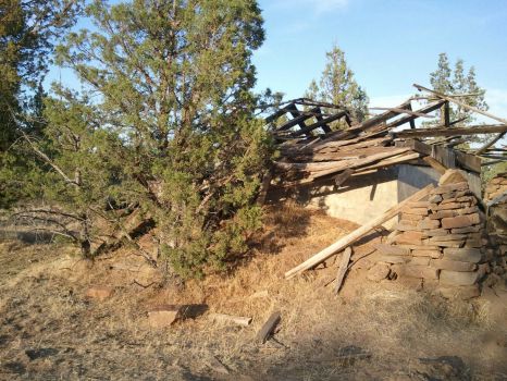
If you look closely, you may spot this old, crumbling cold-storage building. It’s believed to mark the site of the ghost town of Geneva, with the nearby community of Grandview once located just beyond it.
According to the Jefferson County Historical Society, both were farming communities that existed roughly from 1910 to 1930. Together, they supported a small rural network that included a school, Grange Hall, general store, and post office.
The towns formed as homesteaders tried to turn the plateau into a dryland farming district, raising wheat and other crops. But the key challenge was always water….
… A 1915 newspaper noted plans to irrigate the area, yet shallow wells often dried up by May, forcing some residents to haul water from the Deschutes River or buy it by the barrel.
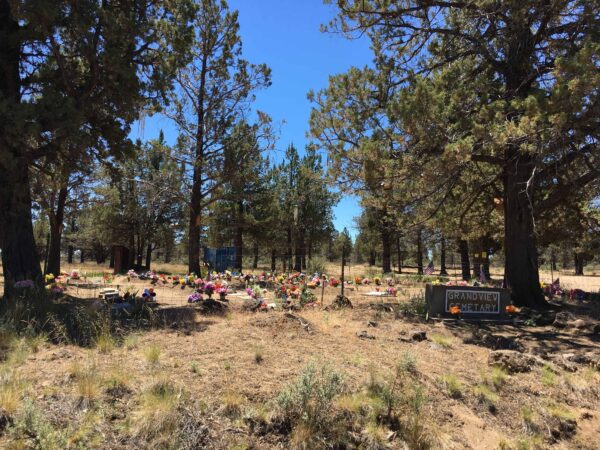
Grandview and Geneva declined due to drought, unreliable water, and increasingly fragile soils, as vegetation disappeared. A prolonged drought beginning in 1917, combined with highly destructive winds during the Dust Bowl, ultimately contributed to the abandonment of both towns in the 1930s. (Pictured to the left is the Grandview Cemetery, just a bit further down the road.)
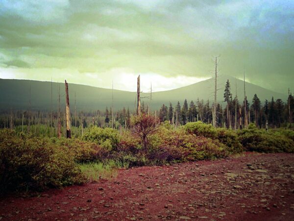
Grandview Fire / ~ Mile 54
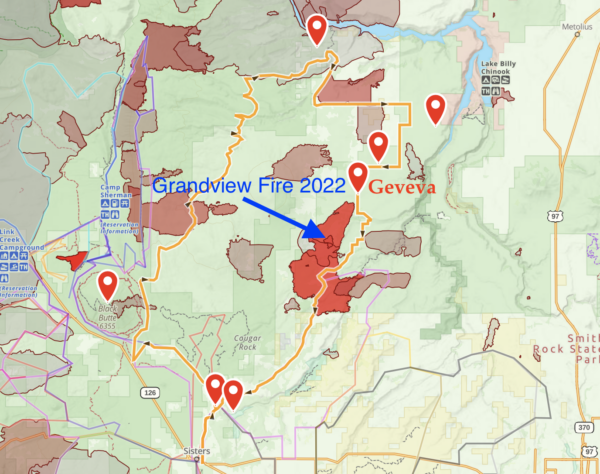
The 6,032 acre Grandview fire just 10 miles northeast of Sisters was reported on July 11, 2021, burning on lands protected by the Oregon Department of Forestry and the Crooked River National Grassland. It took 12 days for fire crews to achieve full containment. The area is flush with lupine during wildflower season, a visual treat in the later miles of this ride.
Green Ridge Fires / ~ Mile X
Credits & Acknowledgements
This ride was funded in part by grants from the Deschutes Trails Coalition and Visit Central Oregon.
When We Like to Ride This
Spring thru Fall. Summer can be hot. Early fall it can be dusty (i.e. “moon dust”).
Terrain & Riding
This ride has a little bit of everything. Slow and lonely pavement, fast and less-lonely pavement, a variety of dirt and gravel surfaces including chunk and possible moon dust. You’ll roll through tall ponderosa forests, burned areas, and wide-open scrub. There’s a nice, balanced mix of climbing and descending but don’t be fooled by the apparent lack of elevation. It’s a big ride, an all-day adventure! Bring the extra snacks.
If doing this when the weather could be warm, pay close attention to your water supplies. It can get very hot – especially on the second half of the route. If there is any question whether you’ll have enough fluid the little market that is 1.5 miles off route at mile ~42. And don’t leave the sun protection at home – you’ll need it! (Note the fire station is often not open and they do not want to hand out water as they have to truck it all in. But in an emergency they will give you water. Just don’t count on it.)
—
Kevin’s Notes for revision to 2.0
Sectors
– Lake Billy Chinook Part 1. Plateaus, benches, basalt cliffs, following lake. Crossing of two arms of lake. On plateau with many Juniper trees, then drop into Fly Creek basin, beautiful descent. Fun and scenic. Steepest climb of day (8% average), as ride up onto ridge. Paved.
– Fly Creek & Akawa Butte
Longest climb of the day. 4 miles at 5 %. Then rolling up on gravel. First lead up through open hilly grasslands into Ponderosa forest. Look carefully when on ridge, can see Mt Hood in distance on clear day. ~ Mile 24. These are proper gravel roads. Keep seeing the butte if keep a keen lookout for it. This sector follows Fly Creek most of the way, just not evident. But near the end of the sector, the canyon ( ~ mile 27.5) to your left is where Fly Creek is and the meadows are where it originates.
Following Fly Creek canyon, a canyon structure is sometimes prominent. Also looping around Akawa Butte. Folklore has it that “Akawa” is of Wasco origin and reportedly is the feminine form of the word “badger”. Badgers at one time were common to the area.
– Green Ridge & Indian Ford Road
Fast paved road on Green Ridge. downhill. Great Views of Black Butte and Black Crater. Light Traffic. Mostly ponderosa forest. Views of Sisters Mountains as well. The. route is front loaded. At the high point on Green Ride at ~ mile 34 (near halfway) you have climbed 3900 feet and descended 1800. From here it is a descent of 3800 feet and 1700 feet of climbing, with no long climbs.
– Big Buck Rd-Grandview.
At first, hard packed dirt road with magnesium chloride that is as fast as paved. Downhill or flat. Once hit National Grasslands, becomes more primitive. Open grasslands with Junipers. Some old growth, mostly invasive. Have not let fire do its part. Clay based, Dirt road with mud ruts. Lumpy . Some washboard. Most technical sector of the day, not very technical. Moderate at most. Just when you had enough of this, it ends.
– Lake Billy Chinook Part2
Route rides faster (mph) than a typical Central Oregon gravel route.
This route has been affected extensively by fires in the last quarter century including xxx fires. Fire is important for forest health and healthy ecosystem and in keeping Juniper tree growth and spread in check. However, fire can also be destructive to those living in these areas as a number of homes have been lost. In the fire zones look for forest re-birth where the fire temperatures were moderate, you may also see scorched areas where the fire was intensely hot and has done long term damage, and you will see how close fire has come to homes on these plains. Our goal is to raise awareness of fire and it impacts, to give you a first hand look at some of the positives and negatives.
Along the ride, you will pass through a number of fire zones:
– Green Ridge Fire
– Grandview Fire. The 6,032 acre Grandview fire just 10 miles northeast of Sisters was reported on July 11, 2021, burning on lands protected by the Oregon Department of Forestry and the Crooked River National Grassland. It took 12 days for fire crews to achieve full containment. The area is flush with lupine during wildflower season, a visual treat in the later miles of this ride.
– check others
The Start
Fee required. Flush toilets, water.
Lat / Long: 44.542306, -121.257307
At the top of the grade, before descending to Lake Billy Chinook, there is a campground and parking area to your left (south). Water, flush toilets. This adds 2.5 miles and 500 feet of gain in total.
Food & Water
- ~ Mile 42: Lake Chinook Village Store (Continue 1 mile off route). Food and water at Lake Chinook Village store. Just before mile 42, instead of turning right, continue on the pavement for another mile or so to Lake Chinook Village store (241 SW Jordan Rd / 541-420-3704).
- Sisters: Many options. Off route by x miles.
Route Notes
Route Options
Shorter: Start in Sisters, Clemens Park. Makes proper loop, but give up the beautiful Lake Billy Chinook sector with basalt cliffs and the crossing the Crooked and Deschutes Arms of the lake. Some of the most spectacular road riding in Central Oregon.
Bikepacking: Indian Ford Campground. When developed campgrounds are available, we do not encourage dispersed camping. In high use recreation areas like this, we believe is more responsible and sustainable to use a developed camp area. There is less environmental impact like trampled grounds, pee smells in the woods that distrub or attract wildlife, and poo it cat holes. This just isn’t sustainable when better options are close by.
Credit Card Tour: At Indian Ford Campground, take the single track into sisters. Next morning, ride out along Camp Polk Road. Here is the route file.
Love Where You Ride! Learn More
 Most of this route is on the public lands of the Deschutes National Forest and the Crooked River National Grassland. Did you know that public lands are special because they belong to every American and that is why we get to do things like bike, run, and hike through these landscapes? They provide immeasurable value for wildlife habitat, clean water, biodiversity, and natural beauty. Without public lands access, many of our routes (and therefore all the enjoyment we get out of them) would not be possible.
Learn more about what you personally can do to help keep public lands public.
Videos
Lake Billy Chinook: The History
Did you know Lake Billy Chinook is co-managed by the Confederated Tribes of Warm Springs and the state of Oregon? That it is important for both power generation and fisheries. And that it is a reservoir, not a lake, at the confluence of three rivers: The Deschutes, the Crooked, and the [...]
Columbia River Plateau Basalt
Massive lava flows covered much of the inland Northwest 17 million years ago. The basalt surged to the surface through fissures - like cracks in the bottom of a row boat. The stack of basalt layers is more than 2 miles thick at some locations. Learn a bit more about this geological feature in [...]
Podcasts
All About Basalt with the Rock Doctor
You will find these rocky columnar cliffs in Eastern and Central Oregon, but what exactly happened to form these unique structures? In this podcast, we talk with our resident rock doctor, Dr. Kim Ely.
Keep it Local! Learn More
Ridden and Reviewed by:


 Behind every route is scouting, mapping, storytelling, and a whole lot of pedal power.
Have you ridden this route? Got a question? Join the discussion!