Big Bird


Caution! We do not provide turn-by-turn directions in our GPX files. Those are auto-generated by your bike computer and are usually less than 70% accurate. Learn more.
For help loading a GPX file onto your bike computer, go here.
DownloadHighlights & Remarkable Spots
Malheur Lake / @Start
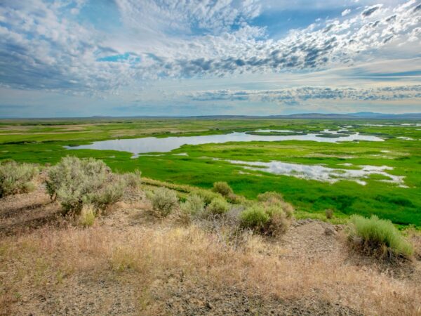
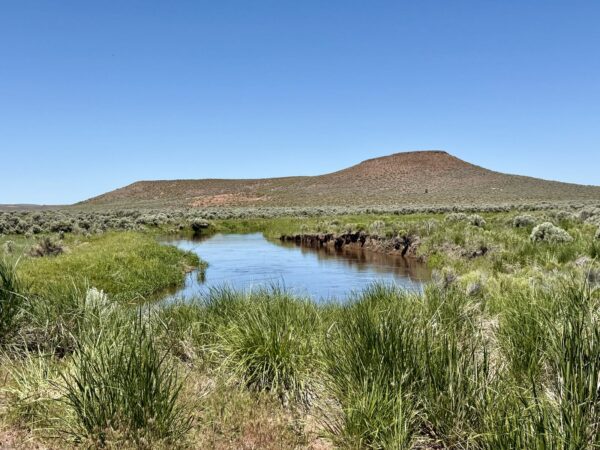
Looking out over the Refuge headquarters, you may see a vast lake or you may see no evidence of a lake at all. But Malheur is not an actual lake. It is one of the largest inland marshes in the United States varying dramatically in size from 500 to 110,000 acres, with up to a depth of 8 feet. The “lake’s” water level and size is determined by how much water it receives from the Blitzen and Silvies Rivers, the snowpack on Steens Mountain.
Meeks Wagon Train / Near the Start
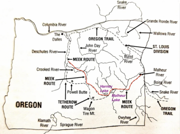
The Meeks Wagon Train of 1845, led by frontiersman Stephen Meek, was an ill-fated attempt to find a shortcut to the Willamette Valley in Oregon. Approximately 1,000 emigrants with 200 wagons departed from the main Oregon Trail near Vale, Oregon, and ventured into the uncharted high desert. As the wagon train entered the Harney Basin, finding water and feed for their livestock became critical. They camped near Harney and Malheur Lakes, but the alkaline water was unsuitable for humans or animals. The group eventually reached The Dalles, but not before enduring the harsh conditions of the high desert. Reports of deaths during the journey range from 23 to as many as 50. Click on map.
Steens Mountain / Recurring Views
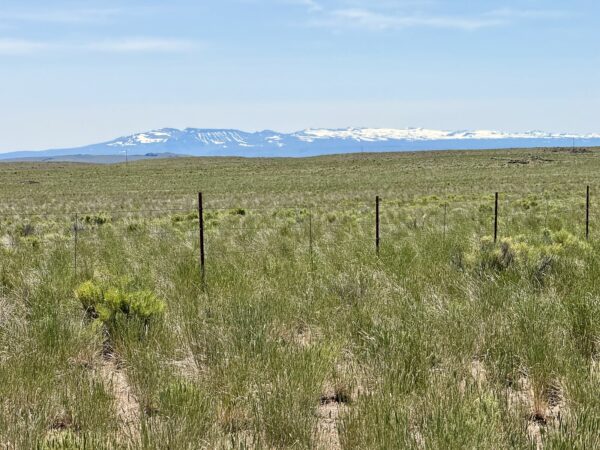
With a summit approaching 10,000 feet, it is a classic fault-block mountain, gently sloping on its west side, but dropping vertically a mile to the Alvord Desert on its east side. Snow melt from the broad western face is carried downhill by five major streams, which eventually merge to become the Blitzen River. Over the eons, the river has deposited many feet of sediment on the valley floor. These fertile soils, combined with the waters of the Blitzen River, provide an optimal foundation for the marshes and wet meadows of the Refuge.
Donner Und Blitzen River Crossing / ~ mile 12.5
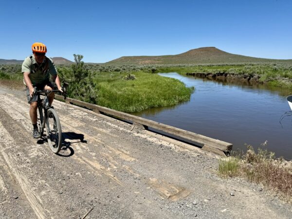
Named in 1864 by an Army Commander of German origin, “Donner und Blitzen” translates as “thunder and lightning. The snow- and spring-fed river and its tributaries cut through dramatic canyons before passing onto the flat open wetlands of the Refuge. The Blitzen River originates on the western slope of the Steens Mountains and flows 91 miles north to the Malheur National Wildlife Refuge, where there is no outlet; 87.5 miles of this river are designated as Wild and Scenic.
Rattlesnake Butte / ~ Mile 13
Rattlesnake Butte, which appears to your right, has been important to people since prehistoric times. Nearby, a rocky ledge extends across the Blitzen River providing the only natural crossing for miles. This point of access, along with the availability of water and a butte from which to survey the surrounding land, made this an important place for bands of Northern Paiute people who first occupied the Blitzen Valley as early as 9,600 years ago.
Russian Olive Trees / ~ Miles 13 to Finish
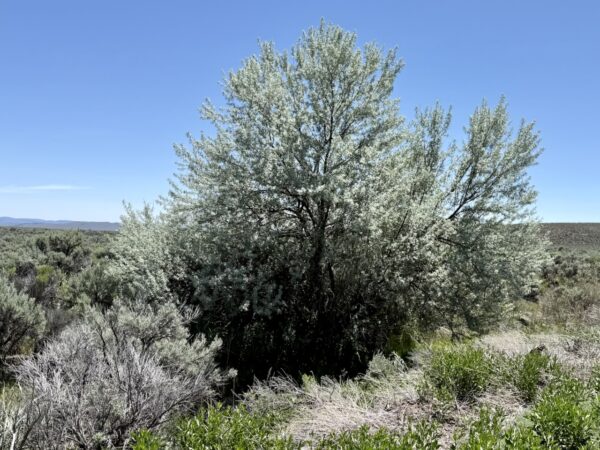
Periodically throughout the route you will see these trees. Russian Olive Trees are native to Eastern Europe and Asia. Introduced to North America in the early 1900’s, these trees initially provide habitat diversity, but within a short time, exponential growth occurs and they begin to out-compete native plants. The Malheur National Wildlife Refuge has worked hard to diminish the population, but it is not feasible to eradicate this species because it is well established in the Harney Basin and fruits being highly sought after by birds for its fleshy high energy seed coating are eaten and distributed through scatt across the landscape.
Malheur Field Station / On Longer Option
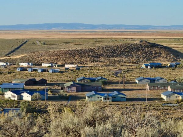
The mission of the Malheur Field Station is “to promote environmental education in the northern Great Basin.” Built in 1965 as a Job Corps Center, the Malheur Field Station has seen several iterations over the years. By the late 1980’s, the Great Basin Society, Inc. (a non-profit) was established to continue the educational mission of the Field Station. Owned by the US Fish and Wildlife Service, the land is leased to the Great Basin Society so that it can continue in its spirit of education and stewardship.
Sod House Ranch / On Longer Option
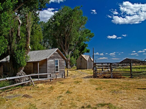
This ranch was the northern headquarters of the 140,000 acre cattle empire of Californian Hugh Glenn. When the Californian Legislature ended open range grazing in 1872, Glenn sent 23 year old Pete French to Eastern Oregon to establish a cattle ranch. French traveled from California with 1200 long horn cattle, six Mexican vaqueros (cowboys) and a Chinese cook to this remote corner of Oregon. Over the next 25 years French acquired property using a variety of methods in the Blitzen, Diamond, and Catlow Valleys to create one of the largest cattle ranches in the United States. The ranch is open to the public from August 15 through October 15. Explore this detailed guide to the ranch.
When We Like to Ride This
Spring to early summer (peak mid-May to mid-June) is especially spectacular at Malheur National Wildlife Refuge, with over 130 bird species nesting there and many others stopping to rest and refuel during their northern migration. We highly recommend checking out this Watchable Wildlife guide and this Spring Migratory Bird Arrival Dates guide by the US Fish & Wildlife Service for detailed information on when and where to spot specific birds.
Terrain & Riding
This route is a true adventure, in contrast to the nearby Bird Nerd route, which offers a lighter, more playful experience—more like a fun Disney ride.
The beginning lulls you into believing you will be back to the start in two blinks, but not so fast, there, speedy. Soon enough, you turn down Big Bird Road, which starts out as a major ranch road and then slowly dissolves. Once you pass the ranch house, the road gets smaller… And then rougher… And then smaller and rougher. Until you are on a road (trail?) where rock dodging becomes the game of the day.
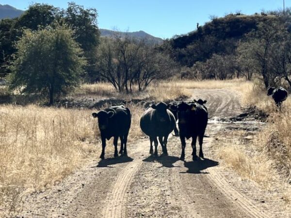
Now, if you do not know the difference between a cow and a bull, you should study our resource page. There’s a good chance you will be negotiating with four-legged creatures on who exactly has the right of way. Not to fret, it was easy enough for us to hike around herds that decided not to move.
But while you are in the cattle grazing area, keep your eyes peeled for pronghorn, coyotes, snakes, eagles and hawks. We also loved the distant views of Steens Mountain, which, on a spring day, will frame your photos with snow.
When you reach the wildlife refuge, you are rewarded with an easy, straight gravel road that often has water on two sides. The marshes are teeming with birds. Fingers crossed you don’t end up with a headwind.
From mid-August through October, follow the route past the Malheur Field Station (around mile 21, with buildings dating to the early 1960s) and continue several miles further to visit the historic Sod House, which is open to the public during this time. Outside of this period, stay on the main route by continuing straight, as described under the “Options” tab.
Back at the start, stash your bikes and spend time wandering around the Malheur HQ, including a trip to the store. The hiking trails at the pack are the perfect way to see more birds and enjoy an easy cool-down. Or grab your favorite post-ride snack and enjoy the view.
Bug spray is a good idea unless you plan on never stopping for anything greater than a minute. Birdwatchers seem to be a major feast for the well-trained mosquitoes that will find you.
The Start
Malheur National Wildlife Visitor Center
Food & Water
- None.
Route Notes
You may come across cattle grazing freely along the route. Before you ride into the herd like a gravel cowboy, take a moment to check out our resource page on Cows—it’s full of tips for passing safely.
A few things to consider before approaching: Is there a bull in the bunch? Any protective mommas with young calves? These factors matter.
The worst approach? Charging through the herd while whooping and hollering like it’s a rodeo. That only stresses the animals and can lead to unpredictable (and unsafe) behavior. A calm, measured approach is best. Sometimes you may even need to stop, remove your helmet and sunglasses so you look more human, and walk your bike past the herd.
Think about it: If a pack of six strange creatures with giant heads, bug eyes, and four spinning limbs (two wheels + two legs) came speeding toward you… wouldn’t you be tempted to run—or fight?
The second half of the route, along Center Patrol Road (miles 12 to 24), has been known to develop severe washboarding. If you’re concerned about this, contact the Malheur Field Office (541-493-2612) to check the current road conditions and find out when it was last graded.
If you go during birding season, carry mosquito repellent with you … or move really, really fast!
Explore the Malheur Wildlife Refuge website to access seven brochures featuring information on birdwatching, the auto tour route, wildlife, the historic Sod House, and more.
Route Options
Longer
At ~ mile 19.5, there is an option to ride by the Malheur Field Station and to visit the historic Sod House Ranch. We only recommend this option when the ranch is open: from August 15 to October 1. If you choose this route, stay left at mile 19.5 and head north towards Sodhouse Lane. At Sodhouse Lane, turn right (east) and then look for a sign directing you to Sod House Ranch on the right (South) side of the road. Once you are finished with your visit, head back to Sodhouse Lane, turn right, and meet back up with your car in a couple of miles.
- Route Map: Big Bird (Sod House Extension)
- GPX File: Download
Love Where You Ride! Learn More
![]() The Friends of the Malheur National Wildlife Refuge are doing some awesome work on the Refuge. They’ve fixed up the Refuge Headquarters Historic Barn, built some cool bird-watching and nature trails, put up signs for the Blitzen Valley Refuge auto tour, and lots more.
The Friends of the Malheur National Wildlife Refuge are doing some awesome work on the Refuge. They’ve fixed up the Refuge Headquarters Historic Barn, built some cool bird-watching and nature trails, put up signs for the Blitzen Valley Refuge auto tour, and lots more.
Plus, they run neat programs like the Artist in Residence-Youth Wildlife Art Program and do events like the National Wildlife Refuge Celebration week every October. If you’re into what they’re doing, think about throwing a few bucks their way. Every little bit helps, whether it’s $10, $25, or whatever you can spare.
Videos
Preserving the Harney Basin
This 5-minute video highlights the tremendous value of partnerships to enhance and preserve the Malheur National Wildlife Refuge and surrounding private lands in Harney Basin. The issues facing th Basin are larger than any one person, group or agency can address alone, but together, [...]
Podcasts
Deceptive Waters of Malheur Lake
Located in Harney Basin in eastern Oregon, Malheur Lake sits within the 187,000 acres of Malheur National Wildlife Refuge, an area that is an important wildlife habitat. Aquatic Biologist, [...]
Be Informed!
Keep it Local! Learn More
Ridden and Reviewed by:


 Behind every route is scouting, mapping, storytelling, and a whole lot of pedal power.
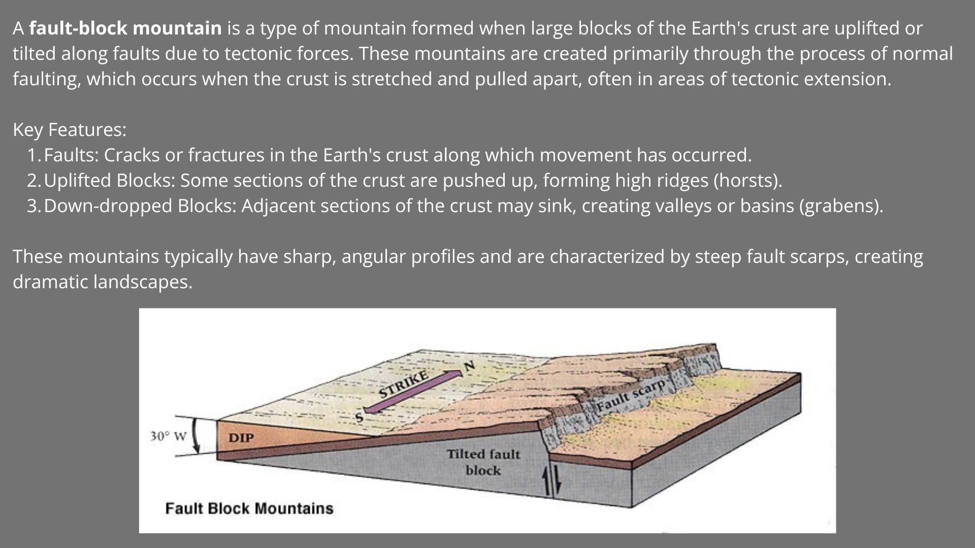
Have you ridden this route? Got a question? Join the discussion!