Boxcar


Caution! We do not provide turn-by-turn directions in our GPX files. Those are auto-generated by your bike computer and are usually less than 70% accurate. Learn more.
For help loading a GPX file onto your bike computer, go here.
DownloadHighlights & Remarkable Spots
Deschutes Railroad Wars / ~ Miles 0 to 7.5
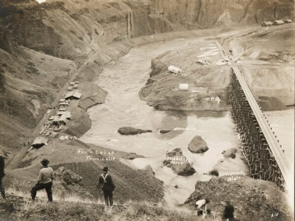
From 1909-1911, a bitter power struggle between two great rail companies occurred here, each vying for control of a vital route to the vast timber and agricultural resources of central Oregon. Each company employed roughly 3,000 workers to blast, dig, build, and tunnel through tons of rock in a 150-mile race to the interior.
Competition was keen, and tempers ran high, with the occasional exchange of gunfire and sabotage. These two rail lines were the last to be built with hand tools and horses.
Competition was keen, tempers ran high, with occasional exchange of gunfire and sabotage. In fact, these two rail lines were the last of their kind to be built with hand tools and horses.
Maupin Section Foreman's House / ~ Mile 0.7
Built in 1910 by the Des Chutes Railroad Company, the Maupin Section Foreman’s House was a key part of the region’s railroad operations. It served as the home of the section foreman, who oversaw track maintenance in this remote and arid landscape.
The house was originally part of a larger railroad complex that included a depot, a warehouse, and bunk quarters for the maintenance crew. Together, these structures formed the Maupin station, a critical hub along the line.
The house, designed to endure the intense heat of the canyon, followed a standard railroad blueprint of the era. Its wraparound porch provided much-needed shade, offering a cool retreat after long days on the tracks. On especially hot nights, the foreman could even sleep outside, taking advantage of the open air.
Boxcar Rapids / ~ Mile 2.3
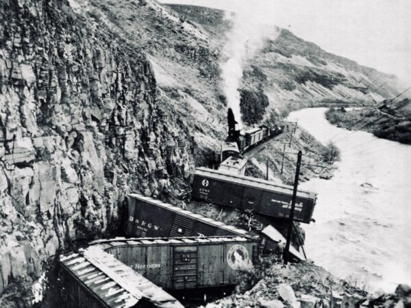
Boxcar Rapids is a Class III rapid on the Deschutes River. The rapids were named after a catastrophic train derailment in January 1954, when a Spokane, Portland and Seattle Railway train struck a rockslide, causing locomotives and boxcars to plunge into the river. This tragic event resulted in the death of several crew members.
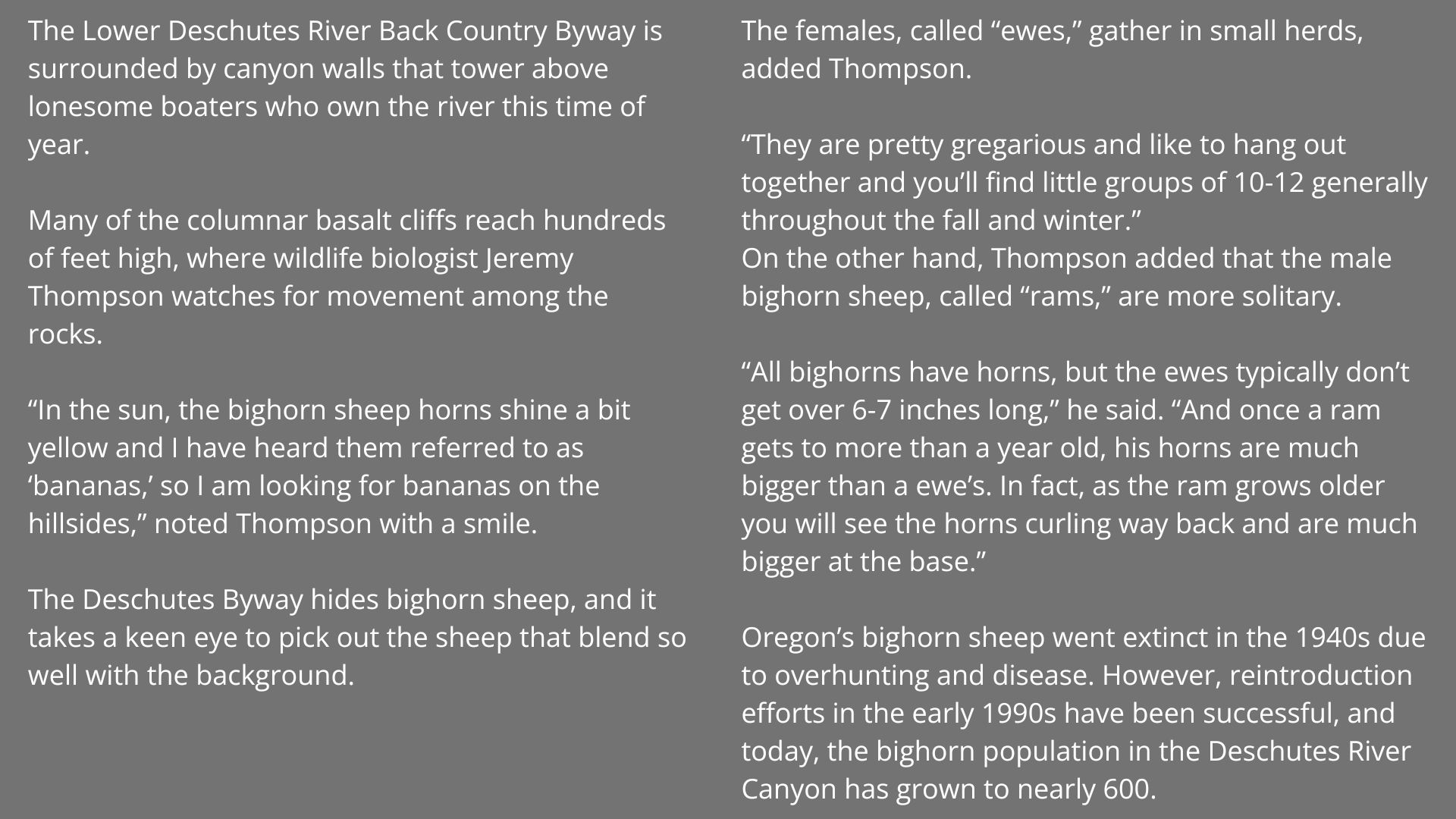
Bighorn Sheep / ~ Miles 1 to 7.5
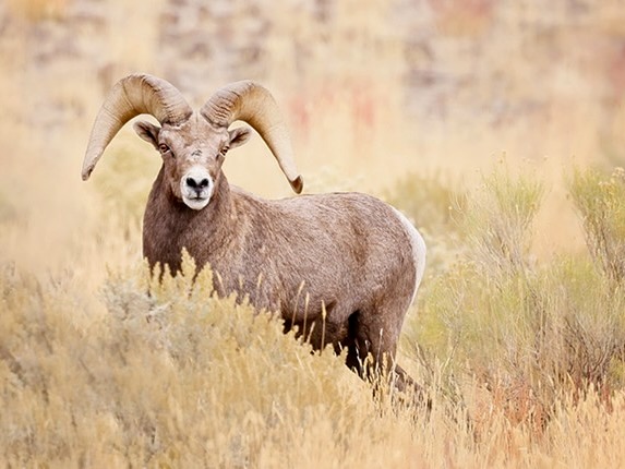
Oregon’s Deschutes River Canyon bighorn sheep went extinct in the 1940s due to overhunting and disease. However, reintroduction efforts in the early 1990s have been successful, and today, the bighorn population in the Deschutes River Canyon has grown to nearly 600.
“In the sun, the bighorn sheep horns shine a bit yellow and I have heard them referred to as ‘bananas,’ so I am looking for bananas on the hillsides,” noted wildlife biologist Jeremy Thompson with a smile.
Learn more about the Deschutes River Bighorn Sheep with Jeremy here.
Lower Deschutes River Fishing / ~ Miles 2 to 7.5
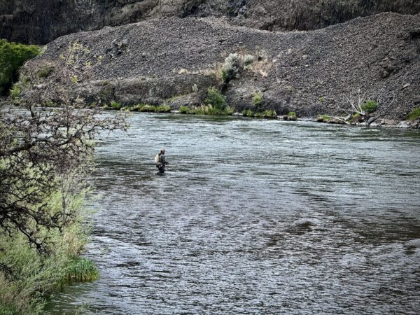
The Lower Deschutes River is a premier fishing destination known for its wild redband trout and summer-run steelhead. The river’s cold, oxygen-rich water and diverse insect hatches make it an ideal habitat for these prized fish, attracting fly anglers from across the country. The salmonfly hatch in May-June and caddisfly hatches in summer are legendary for trout fishing, while steelhead runs peak in fall.
Kiosk / @Turnaround Point
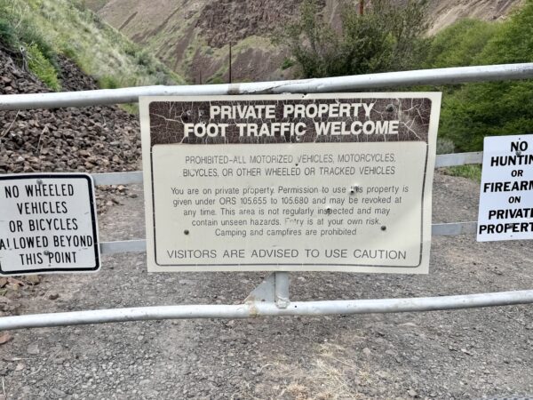
At the end of the road you will encounter a gate and private property sign. You can walk further along the old railway grade, but you cannot cycle beyond this point. Beyond the gate the rugged landscape becomes more awe inspiring.
We are working the BLM to place a kiosk here that gives more history of the railroad wars. Some of the money from your donations goes to efforts like this.
Credits & Acknowledgements
This route guide was funded in part by a grant from Travel Oregon.

When We Like to Ride This
This ride is really, really good during the shoulder seasons. Maupin’s low elevation of just 900 feet means little to no snow and frequent sun. We’ve ridden here as early as February and as late as December. Ideal winter conditions are sunny days with temps above 50°F. May and June are especially stunning, with green canyon grasses and a full, fast-flowing river. Fall is also a favorite—quiet, peaceful, and golden.
If you’re riding in mid-May to early June, be aware it’s prime fishing season due to the salmonfly hatch. Anglers flock to the river during this time, as trout aggressively feed on the emerging insects. To avoid the crowds, consider riding in the evening; the light is gorgeous, and the riverbanks are quieter.
Note: In the summer months, this ride can get very hot. Go early to beat the heat and enjoy the cool canyon air.
Terrain & Riding
The Terrain
The terrain is striking and rugged, defined by towering basalt cliffs, rolling sagebrush-covered plateaus, and the turbulent Deschutes River. Over millions of years, the river has carved through ancient lava flows, creating steep canyon walls that rise sharply from the water, separating the narrow, picturesque river corridor from the wide-open high desert above.
The Riding
The gravel can vary on this route, from firm hard-packed and smooth, to course, to washboarded. It all depends on season and when last graded. If you ride this route, please leave a comment on the conditions.
Tips & Tricks: Dial In Your Tire Pressure
If the gravel feels rough or jarring, try lowering your tire pressure. For 45 mm tubeless gravel tires, you can safely run pressures as low as 10–15 psi, depending on your weight and riding style. Start high and drop the pressure gradually until the ride feels smooth and stable.
Look for a 5–15% tire deflection (that slight bulge where the tire contacts the ground); on rougher terrain, you can go up to 25% for added comfort and grip. This ride is a great place to experiment—it’s not remote, and there’s usually vehicle traffic and people around if you need help.
The Start
Dirt parking lot adjacent to and just to the south of Maupin City Park. Water. Flush toilets.
Food & Water
- None.
Route Notes
You will be sharing this stretch of river with fisherman and rafters. It is known as a world class fishing destination.
Rafting on the Lower Deschutes River near Maupin, is a popular adventure, offering a mix of thrilling whitewater rapids and scenic canyon views. The river features Class II-IV rapids, making it suitable for both beginners and experienced rafters. Key rapids include Wapinitia, Boxcar, and Oak Springs, which provide exciting challenges.
The town of Maupin serves as a central hub for rafting trips, with multiple outfitters offering guided tours and equipment rentals. The river’s warm summer temperatures, rugged basalt cliffs, and abundant wildlife make for an unforgettable experience.
There are 19 BLM campgrounds along the Deschutes River, stretching from Devil’s Canyon (about 6 miles south of Maupin) to Macks Canyon (about 29 miles north of Maupin). All campgrounds are equipped with vault toilets, but none have potable water, so plan accordingly.
Maupin has a full-service grocery store. One of the restaurants open year-round is ..
Route Options
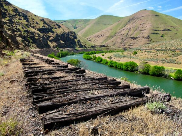
At the end of the ride, you have the option to continue exploring on foot. The road beyond this point crosses a mix of public and private land, and bike access is not permitted. However, on foot, you’ll find the canyon grows more dramatic, the river wilder, and the road quieter. The dirt road continues approximately another 5 miles to Dant, an old ghost town along the railroad tracks.
Dant, traces its roots to the 1909 railroad race through the Deschutes River Canyon, when rival companies built competing lines on opposite sides of the river. A siding station named Frieda—later Dant—was established on the west bank, setting the stage for later development. In 1945, Dant & Russell opened the Lady Frances perlite mine there, building a mill and tile manufacturing plant that briefly transformed the remote canyon site into an industrial outpost. Learn more.
Bring a bike lock if you plan to venture farther in.
Love Where You Ride! Learn More
 This ride takes you deep into the heart of the Deschutes River Canyon, a place defined by dramatic geology, rich ecosystems, and deep cultural significance.
Over millions of years, the Deschutes River carved through ancient lava flows, exposing layer upon layer of the Columbia River Basalt Group, some dating back more than 15 million years. The result is a rugged, otherworldly landscape of steep canyon walls—rising up to 2,500 feet—in sharp contrast to the high desert plateau above.
The canyon’s riparian corridor supports a wide array of wildlife, including bald and golden eagles, bighorn sheep, mule deer, beavers, and river otters.
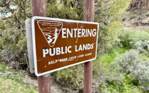
The Bureau of Land Management (BLM) plays a key role in protecting and managing this landscape, balancing habitat conservation, public access, recreation, and cultural resource stewardship.
Now more than ever, it’s important to support organizations like the BLM. That support can come in many forms—picking up litter, joining a volunteer work party, reporting trail damage, or simply sending a quick note of appreciation. Whether it’s your time, talent, or a small donation, it all helps protect the places we ride and love.
Videos
The Ride! Boxcar
A quick 2+ minute video of what to expect on your ride.
The Deschutes Railroad War
Railroad historian and attorney Martin Hansen talks about the race between two railroad barons to build a railroad line through central Oregon.
Deschutes River Canyon Bighorn
Bighorn sheep in the Deschutes River area went extinct in the 1940s, but thanks to a reintroduction effort in the early 1990s, their population has grown to 600. Learn how to spot these muscular creatures among the basalt cliffs with wildlife biologist Jeremy Thompson in this 2-minute video.
Podcasts
All About Basalt with the Rock Doctor
You will find these rocky columnar cliffs in Eastern and Central Oregon, but what exactly happened to form these unique structures? In this podcast, we talk with our resident rock doctor, Dr. Kim Ely.
Keep it Local! Learn More
Related Guidebooks
-

All Access Gravel Guide Eastern Oregon (Collector’s Edition!)
$12.50Now shipping! A 64-page pocket-sized gravel guide. Featuring gravel routes, art, culture and local history. A one of a kind…Add to cart -

All Access Gravel Guide Western Oregon (Collector’s Edition!)
$12.50Now shipping! A 64-page pocket-sized gravel guide. Featuring gravel routes, art, culture and local history. A one of a kind…Add to cart
Ridden and Reviewed by:


 Behind every route is scouting, mapping, storytelling, and a whole lot of pedal power.
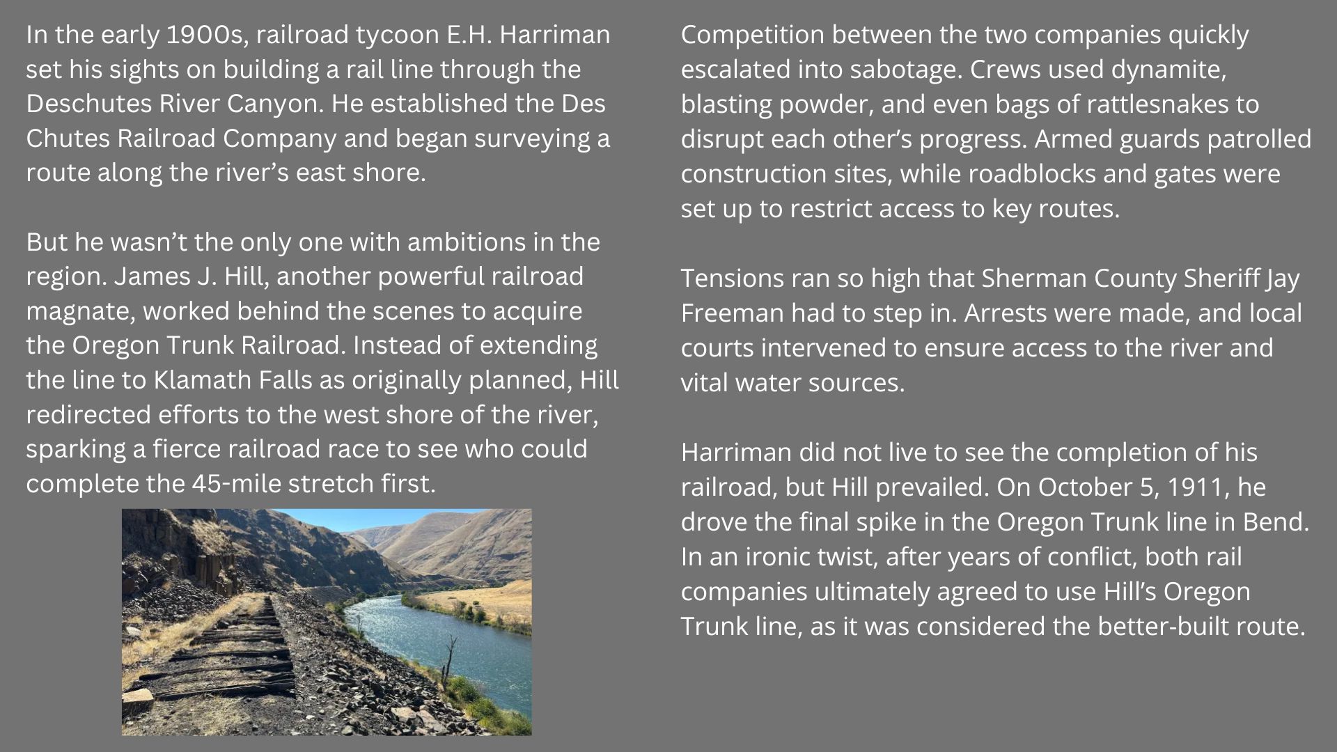
Have you ridden this route? Got a question? Join the discussion!