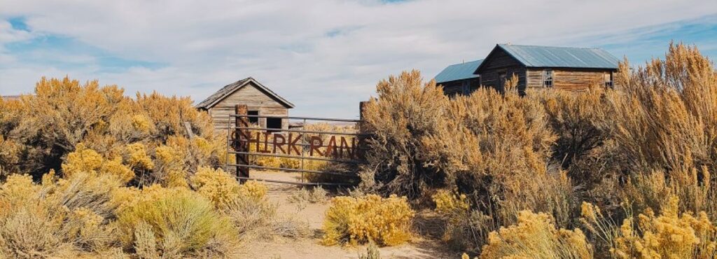
Shirk Ranch


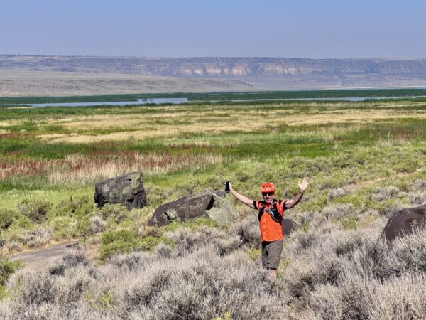
This adventure begins long before you begin to push the pedals. Driving to the ride start from Lakeview offers up several unique points of interest (all documented below): drive-by art sculptures, mountain peaks, gorgeous wetlands, and more. But the true highlight of the day awaits 12 miles down a desolate dirt road: the historic Shirk Creek Ranch.
Shirk Ranch
The Shirk Ranch property was originally homesteaded by R.A. Turner around 1881 and then sold to William Herron. Shirk bought the ranch from Herron in 1883. When Shirk purchased the land, there were three buildings on the property: a house and two sheds. There is no record of the property size when Shirk bought it, but county tax records show the ranch was 480 acres in 1887.
Shirk was a well-known cattleman. In 1869, he assisted with the first drive of Texas cattle to Oregon and reportedly held up to 50,000 acres of Oregon rangeland. But this ranch in Guano Valley was different. It wasn’t a cattle ranch.
Shirk purchased the Guano Valley site as a horse ranch and wrote that he “at once began improving the property to accommodate a large number of horses and mules.”
“These I raised myself, shipped to market, . . . and sold them,” he wrote, “and in this I did fairly well.”
Horse raising was a key industry well into the twentieth century, before the automobile and mechanized farm machinery were widely available. Demand was high. Oregon horses raised by stockmen like Shirk even ended up at war on two foreign continents, supporting military actions in South Africa’s Boer War and, later, World War I in Europe.
Family was essential to Shirk’s ranch operations. “I and my family, including my wife and children, were almost constantly in the saddle, doing our work and lessening expenses,” he wrote.
Shirk also relied on the help of ranch hands. “I endeavored to secure as employees the better class of young men,” he wrote. “I had constructed an elegant country home, and all were treated as equals. They ate their meals with me and my family, and in other respects were treated as equals.”
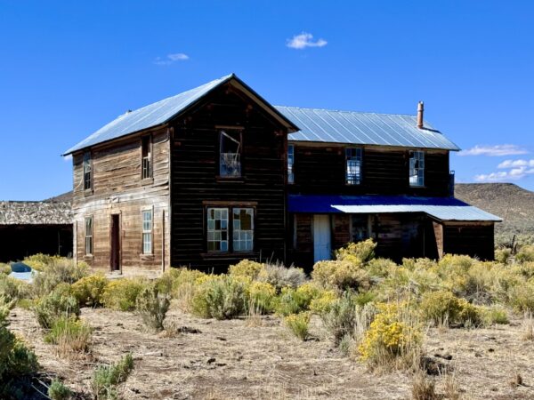
Today, after more than a century, the site’s main house today offers clues to Shirk’s egalitarian vision. This building’s second floor features a large, rectangular room that probably held, of all things, a billiard room.
“Upstairs,” Shirk wrote, “I fitted up a billiard room, placing therein a modern billiard table for their amusement during times of idleness and the long winter nights. I had a two-fold purpose in this. First, because I believe that every man is as good as any other man, provided he is honest, industrious and conducts himself as a self-respecting man, and also, because I sought by this means and by such methods to secure contentment and steadiness on the part of the men in my employ.”
In 1914, Shirk sold the Guano Valley Ranch to the partnership of Mitchell and McDaniel of Cedarville, California. Shirk’s daughter, Olive, known as one of the best “horsemen” in the area and a “tough ranch lady,” leased the Shirk Ranch with her husband, Zetus Spaulding, from the Bank of Willows, California, which had acquired it in foreclosure from the Mitchell and McDaniel Partnership. The ranch became part of the Hart Mountain National Wildlife Refuge in 1942. Shirk’s daughter and husband lived and worked on the ranch until Zetus death in 1945. The ranch was leased to various interests through the 1980s but has been vacant since that time. The ranch is now administered by the Bureau of Land Management.
In 2009, the ranch was entered into the National Register of Historic Places in recognition of its national significance. Today, the BLM administers it for public access, keeping it open for intrepid visitors interested in exploring Oregon’s ranching past beyond a drive-by, windshield tour.
Click here for a full multimedia tour of the ranch.
[Ref: Bureau of Land Management]
The reasons to do this ride are to:
– see the historic ranch
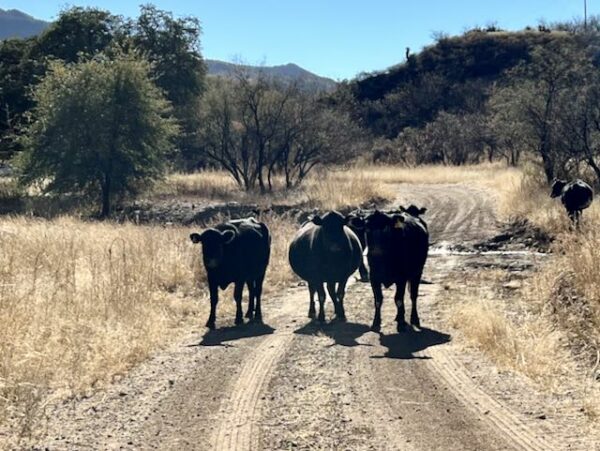
– compare and contrast the desert scape that has been grazed and ungrazed by cattle
– view the striking Dougherty Slide
– and experience the open expanse of the high desert.
Note that this is the most remote All Access ride we have documented. You may see no one and there is no cell phone reception. However, the navigation is straightforward and the road driveable by most vehicles.
Caution! We do not provide turn-by-turn directions in our GPX files. Those are auto-generated by your bike computer and are usually less than 70% accurate. Learn more.
For help loading a GPX file onto your bike computer, go here.
DownloadHighlights & Remarkable Spots
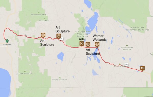
You’ll pass the first five points of interest (POIs) while driving from Lakeview to the starting point of the ride. To help you locate them, we’ve noted their distances from the intersection of Highways 395 and 140—roughly downtown Lakeview.
Click on the map at left to expand view.
Crane Creek Ranch Art / ~ Miles 18, 24, & 34.5 from Lakeview
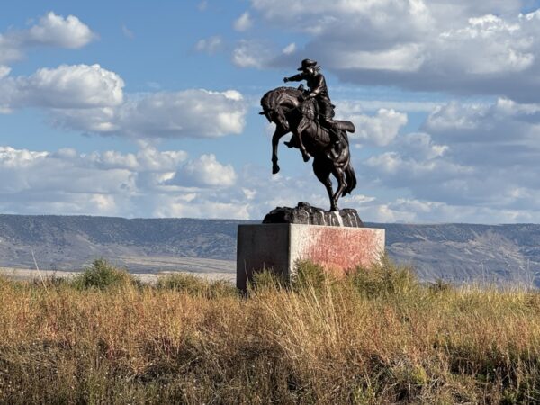
As you head from Lakeview to the start of the ride, keep an eye to the right side of the road—you’ll see several sculptures along the way.
From west to east, there are at least three pieces: Stagecoach, Cowboy Leaning on Horse, and Bucking Horse.
{Marie – does she have info on this?}
Adel / ~ Mile 32.5 from Lakeview
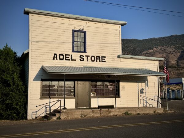
Euro-American settlement of Adel began in the late 1800s, centered around sheep grazing and small cattle ranches. Irish Catholic immigrants worked as shepherds, leaving behind a legacy seen in local surnames and historic churches. A stagecoach line once connected Adel to Fort Bidwell, California, offering service three times a week. The Adel post office was established in 1896. Its name may have come from a landowner’s former sweetheart or a local cow named Leda—spelled backward.
Today, Adel is little more than a one-building ghost town. [Ref: Wikipedia]
Greaser Reservoir / ~ Mile 37.5 from Lakeview
Here you pass the southern edge of the Warner Wetlands at Greaser Reservoir. It is fed by 20-Mile Creek. The water flows north into Crump Lake, through the narrows just below the glass house, and into Hart Lake. The greater Warner Wetlands are a seasonal chain of lakes, marshes, and meadows in the Warner Valley. These wetlands form in spring from snowmelt and rain but often dry up by late summer. Since the valley has no outlet to the ocean, water levels vary dramatically with each year’s precipitation and evaporation.
Barry Ranch / ~ Mile 1.8 of ride
From DonnaR. “My father owned that land and ran cattle there, as well as at the Shirk Place (as we called it) and up through Post Meadows to the Flook Ranch on Hart Mountain. By the time he sold it, the land had been in our family for three generations—his father and grandfather had come from New Market, County Cork, Ireland.
Some of my favorite childhood memories are from the Barry Ranch and the Shirk Place. Since our mother was an artist, we had the only outhouse around with a beautiful oil painting hanging on the inside wall!”
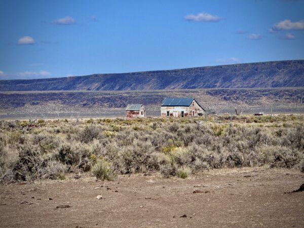
Shirk Ranch / ~ Mile 12 of ride
This property was originally homesteaded during the initial settlement of Lake County in the early 1880s by the Hill family.
David L. Shirk purchased the property in 1883 and built most of the ranch’s extant buildings and structures around 1910. A cattleman by trade, Shirk’s main business at the ranch was said to be horses, and he had a reputation for the “finest horseflesh” in the whole county. Horse raising was a key industry well into the twentieth century before the automobile and mechanized farm machinery were widely available. Early stock was taken from the herds of wild horses that originated from loose animals left by the Spanish. [Ref: Bureau of Land Management]
Grave Site Marker / ~ Mile 12 of ride
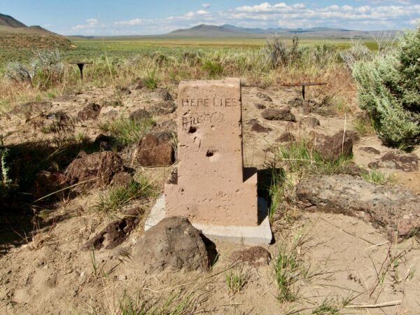
About 500 feet northwest of the main house, a grave marker sits on a knoll overlooking the valley and ranch. The headstone reads: “Here lies Bill Vickers and J. Gruenke, Shot August 14, 1887.” The exact circumstances of their deaths are unclear. According to local folklore, Vickers was a fugitive murderer joined by Gruenke. They ended up at Shirk’s ranch, where trouble followed. One version of the story claims Shirk returned to find them harassing his wife and killed them during the confrontation, later burying them on the hill.
Giant Sagebrush / ~ mile 12 of ride
If you continue riding the dirt road just a bit north of the ranch, you’ll come across an area where the sagebrush stands impressively tall—around 4 to 5 feet. It’s a striking contrast to the shorter sagebrush seen along the route into the Shirk Ranch.
One possible explanation is that cattle are not allowed to open graze north of the ranch, which may have allowed the sagebrush to grow taller. That’s our hypothesis, though it’s not confirmed.
That said, cattle grazing isn’t always harmful to sagebrush. When managed properly, it can coexist with healthy sagebrush ecosystems. Learn more
Doherty Slide / ~ mile 20 of ride
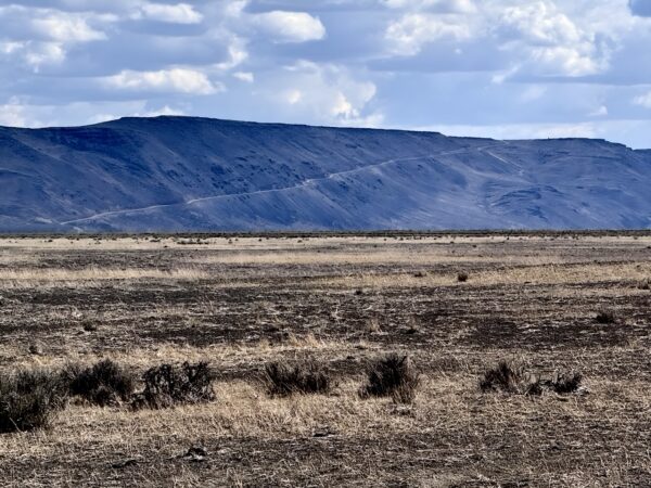
Doherty Slide is a steep escarpment marking the eastern edge of Guano Valley. It rises about 1,000 feet (300 meters) above the valley floor, offering wide views of the surrounding high desert, including the Warner Wetlands and distant volcanic peaks. The ridge was originally formed by lava flows and has since been shaped by erosion, creating the dramatic rim seen today. Despite its name, “Slide” does not refer to an actual landslide. Instead, the term likely comes from the slide-like appearance of the rocky slope or early misconceptions about its geological origin.
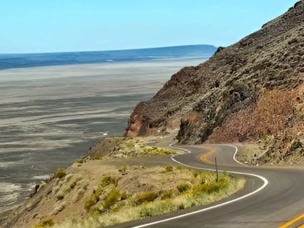
Doherty Slide is one of Oregon’s most dramatic and challenging drives. This stretch climbs approximately three miles with an 8% grade and no guardrails, featuring sharp drop-offs. Doherty Slide is one of Oregon’s highest drivable mountain passes, with an elevation of 6,240 feet.
Doherty Slide is a world-renowned launch site for hang gliding and paragliding. The consistent updrafts created by the cliff face make it an ideal spot for soaring—especially in summer months.
Credits & Acknowledgements
This ride guide is funded in part by grant from Travel Oregon.

When We Like to Ride This
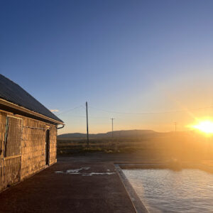
This is a stunning ride—especially at sunrise or sunset—with wide-open views and a real sense of solitude. That said, it’s very exposed to sun and wind, so plan accordingly. Avoid riding when the route is wet or muddy, as conditions can quickly become difficult.
We wouldn’t ride it all the time, but it’s a perfect once-a-season adventure—ideal in spring or fall. If you’re passing through the area, it’s absolutely worth making this a stopover ride.
Terrain & Riding
The Terrain
The terrain is part of one of the largest remaining intact sagebrush ecosystems in North America. It’s remote and wild. It is classic sagebrush-steppe country, where the land is covered in a patchwork of big sagebrush, bunchgrasses, and rabbitbrush, with juniper trees appearing now and then. Subtle changes in vegetation reflect shifts in soil, elevation, and moisture across the landscape.
The Riding
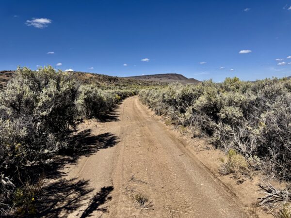
The route follows a hard-packed dirt BLM road through the Guano Valley at an elevation of about 5,100 feet. To your right, in the distance is the Guano Rim rising a 1000 feet above the valley.
The first four miles are wide open and expansive. After that, the road tucks in along the base of a low western ridge, providing a more intimate feel as you ride toward the ranch.
Although the route may appear completely straight on the map, it subtly twists and turns, limiting long sightlines and keeping the ride visually engaging. It’s dead flat—but far from boring!
The Start
Just at the start, make the turn onto the BLM dirt road and park in a pullout to the left.
Food & Water
- None
Route Notes
This is a very remote route. While the risk is lower since it’s an out-and-back and accessible by most vehicles, it’s still important to go prepared.
We do not recommend entering the buildings at Shirk Ranch. It is best to look from outside.
You may come across free-ranging cattle along the route. Check out our Tips and Tricks page for advice on how to handle these encounters—hint: whooping and hollering is not the right thing to do!
Route Options
Longer
If you’re looking for a longer ride that takes you into Shirk Ranch, check out the Guano Creek route (50 miles, 2000 feet of elevation gain). This is a Dirty Freehub Development route that starts in the Hart Mountain National Antelope Refuge.
Love Where You Ride! Learn More
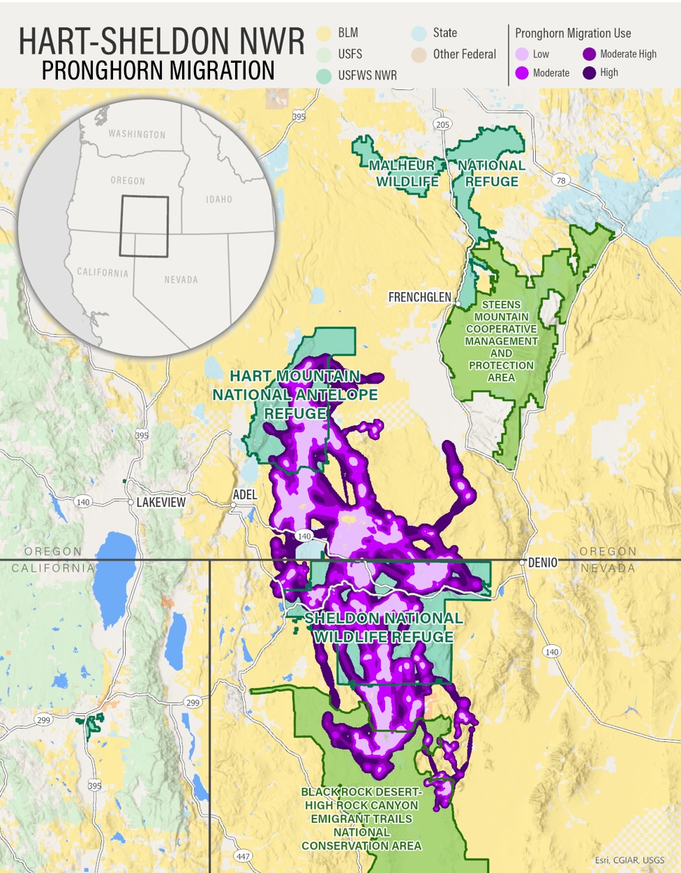 Today, you’re riding through a section of the migration corridor that connects Hart Mountain National Antelope Refuge in Oregon to Sheldon National Wildlife Refuge in Nevada. This is one of the longest and most important pronghorn migration routes in the western U.S.—and one of the few long-distance ungulate migrations that remains mostly intact. (Click on map to right for larger view).
Distance: The migration corridor spans about 100–150 miles.
Seasonality: Pronghorn typically migrate seasonally, moving between higher-elevation summer ranges (Hart Mountain) and lower-elevation winter ranges (Sheldon).
Habitat: The route traverses a mix of sagebrush steppe, open desert, and mountain terrain—prime habitat for pronghorn, which rely on vast, open spaces for visibility and speed to avoid predators.
Videos
The Ride! Shirk Ranch
A quick 2+ minute video of what to expect on your ride.
The Story of Shirk Ranch
In this 2-minute video, explore the history of Shirk Ranch, home to David Shirk and his family in the early 1880s. Shirk Ranch was part of a border movement of ranchers and settlers into southeast Oregon, shaping ranching life that persists today. The ranch illuminates how early settlers to [...]
The Greater Hart-Sheldon Wildlife Corridor
In this 3-minute video, discover the beauty and importance of this remote sagebrush-steppe ecosystem—a unique landscape that supports pronghorn, sage-grouse, mule deer, golden eagles, and more. There’s nothing else like it in the world!
Be Informed!
Keep it Local! Learn More
Related Guidebooks
-

All Access Gravel Guide Eastern Oregon (Collector’s Edition!)
$12.50Now shipping! A 64-page pocket-sized gravel guide. Featuring gravel routes, art, culture and local history. A one of a kind…Add to cart -

All Access Gravel Guide Western Oregon (Collector’s Edition!)
$12.50Now shipping! A 64-page pocket-sized gravel guide. Featuring gravel routes, art, culture and local history. A one of a kind…Add to cart
Ridden and Reviewed by:


 Behind every route is scouting, mapping, storytelling, and a whole lot of pedal power.
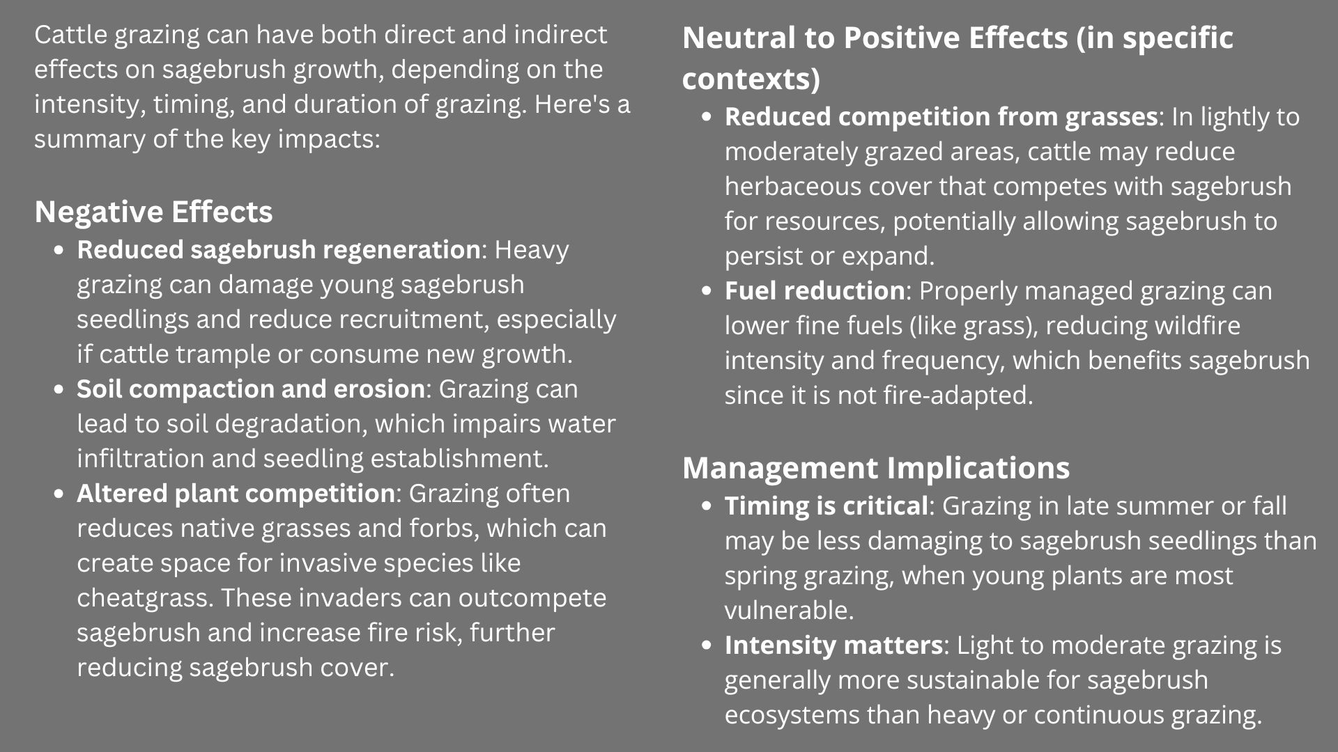
Have you ridden this route? Got a question? Join the discussion!