Rabbit Ears
Read the comments on this Ride Guide for warning of down trees.


Caution! We do not provide turn-by-turn directions in our GPX files. Those are auto-generated by your bike computer and are usually less than 70% accurate. Learn more.
For help loading a GPX file onto your bike computer, go here.
DownloadHighlights & Remarkable Spots
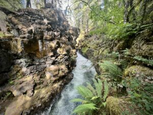
Rogue Gorge, ~ 2 Miles south of Starting Point
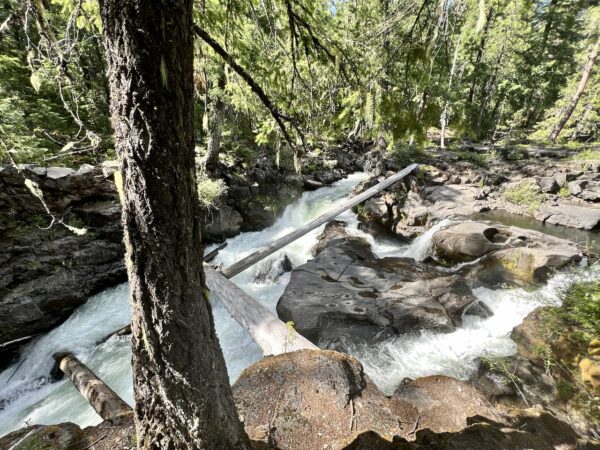
A narrow chasm that is 500 feet long and 25 feet wide at its narrowest point, with roughly 410,000 gallons of water flowing through it each minute – enough to fill an Olympic size swimming pool each minute.2 miles south of the starting point on Highway 62. [Forest Service Kiosk]
Natural Bridge, ~ 3 Miles South of Starting Point
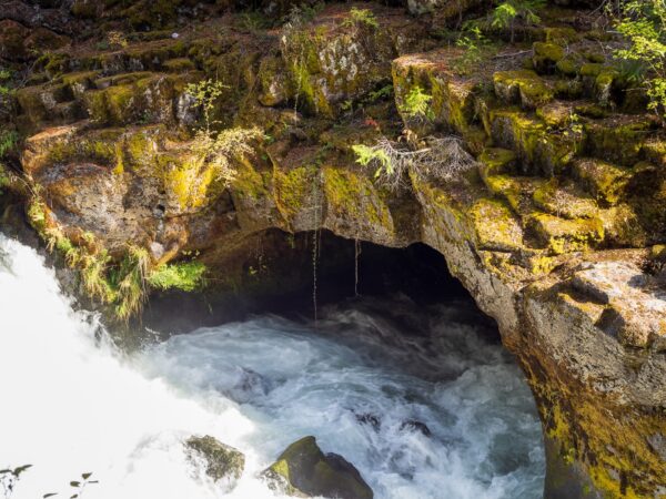
The river disappears into an ancient lava tube, or a natural bridge, taking some 35 seconds to travel 200 feet to reach the tube’s outlet. Seasonal flooding can cause the river to cover the bridge. There are “blow holes” on the surface of the Natural Bridge, small openings that hint of the turbulent nature of the hidden river below. At its peak, approximately 335,000 gallons of water rush from the Natural Bridge each minute at a speed of 6 ft. per second. 3.3 miles south of the starting point on Higway 66. [101 Things To Do]
Big Trees, ~ Mile 5.9 (on right)
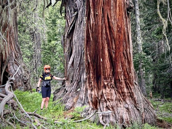
Just before mile 6, look to your right, and you will see a small stand of old-growth cedars. We believe they are Port Orford cedars, but we could use your help in identifying if this is so. Send us a comment if you know so.
Rabbit Ears, ~ Miles 7 to 11
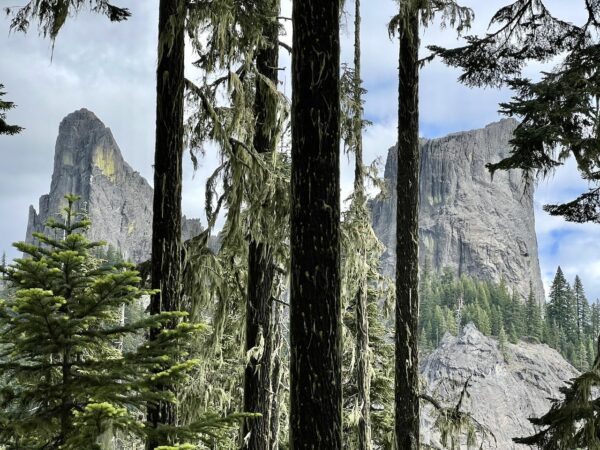
Twin volcanic plugs that rise vertically out of the earth and look like rabbit ears when viewed from certain directions. [Oregon Live]
Hershberger Lookout, Mile 11
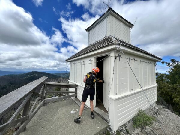
Built in 1925, it originally served as a fire lookout and later as an aircraft warning station during WW2. It still sees occasional use by the Forest Service. From it, there are expansive views of the Upper Rogue River, the Crater Lake rim, Mount Thielsen, Mount Bailey, and Mount McLoughlin. [Hiking Project]
Pup Fire / ~ Miles 8 to 14
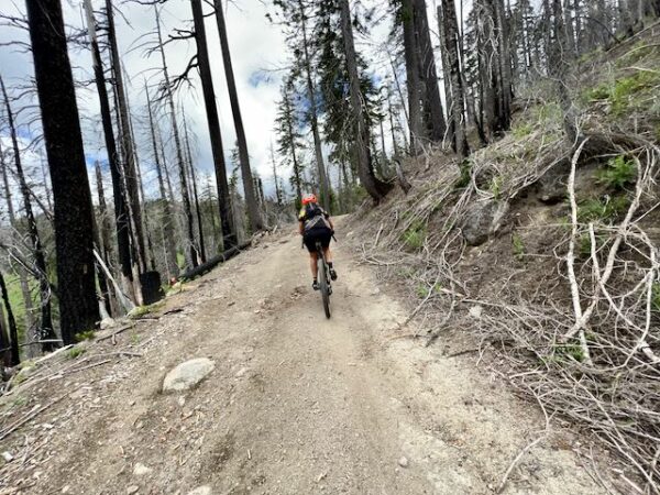
In 2017, after the wettest winter in almost two decades, the Umpqua / Rogue River areas expected a benign fire season. However, the spring rains segued into an exceptionally hot and dry summer. By early August, the area was experiencing record-setting highs with four consecutive temperatures above 100 degrees. By the end of September, thousands of firefighters from across the nation – and even a contingent of active-duty soldiers – would rotate through the Umpqua / Rogue River area to control the fires unleashed by the early August lightning blitz. Before fire season was over, 115 lighting-caused fires would burn more than 64,000 acres on the Umpqua National Forest, including the Pup fire. [USDA]
Healthy Forest, ~ Miles 23 to 28
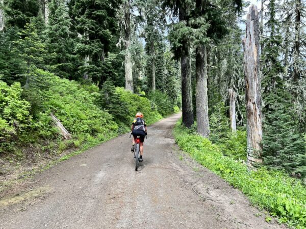
Characteristics of a healthy forest:
(1) Many different plant species – Generally, insect and disease populations target one type or species of tree. A diversity of tree species will ensure that one insect or disease can’t wipe out all the trees. (2) Not crowded – Trees become stressed when they have to fight for sunlight, nutrient and water. This stress makes them more susceptible to attack by insects and diseases. (3) Variety of tree sizes and ages – The greater variety (or complexity) improves a forest’s ability to respond to attack, and supports wildlife. [Caring for Your Woodland – University of Wisconsin]
Terrain & Riding
In this area, the forest’s spectacular scenery has been shaped by high Cascades glaciation, whitewater rapids, and explosive volcanic events. You will experience verdant stands of hemlock, fir and cedar and forests of mixed conifers and hardwoods at lower elevations. Compared to the ponderosa forests of the High Cascades, it is dense and green with a high overhead tree canopy and ferns covering the forest floor.
Overall, the roads are so good. Fast spinning and luxurious. Yes, there are some miles (8) of rugged and steep. Miles 5.5 to 13.5. The road to the lookout is especially rugged and jeep-like. Rutted, gullied, loose with sustained gradients of 10 to 15% for the last 0.5 miles. Rideable, but work. Some will walk it.
The opening climb is long and sustained, 2800 feet in 10 miles. The more you climb, the more demanding it becomes.
The downhill, after turning off the lookout climb road, is “lickity-split” at 2 to 4%; you are not grabbing for a bunch of brake. It is super fun, fast rolling. The second pitch of the descent is steeper at 6 to 10%; however, it is still a good hard-packed gravel road.
The last 8 miles are up and down, a small hill that gains and loses 800 feet. Forest riding where if the sun is shining the greens really pop. An enjoyable end to a great ride!
The Start
A dirt pullout just off Highway 66. There are two options, just before or just after the bridge crossing the Rogue River.
Food & Water
- None
Route Notes
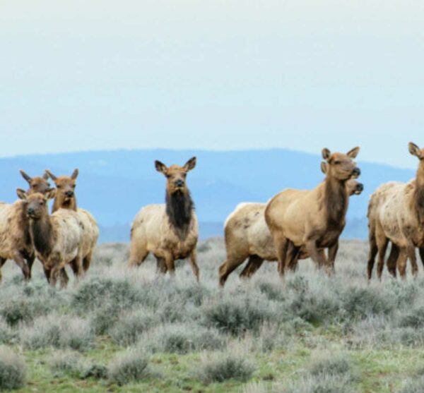
By riding this route, you will have an impact on wildlife. The two most important things you can do as a cyclist are: when encountering wildlife, stop and put a foot down and wait (and wait some more!), and limit your group size to 4 or fewer. For more information on this, check out the Wildlife Impact resource page in the right sidebar.
Route Options
The route rides well in both directions. As mapped (counterclockwise), the route climbs the steeper pitches and gives the big views earlier. The descent is more gradual.
In the clockwise direction, the ascent is less challenging, the descent more challenging, but the bigger views come later.
Love Where You Ride! Learn More
 Before or after your ride, we encourage you to get out and experience two of the scenic wonders of the Rogue River, the gorge (a narrow chasm that is 500 feet long and 25 feet wide at its narrowest point, with roughly 410,000 gallons of water flowing through it each minute) and the natural bridge (an ancient lava tube that the river disappears into creating a land bridge). These two sights are about 3-miles south of the start on Highway 62.
Videos
The Ride!: Rabbit Ears
A quick 2-minute video of what to expect on your ride!
Be Informed!
Keep it Local! Learn More
Ridden and Reviewed by:


 Behind every route is scouting, mapping, storytelling, and a whole lot of pedal power.
Have you ridden this route? Got a question? Join the discussion!