The Dredge


Caution! We do not provide turn-by-turn directions in our GPX files. Those are auto-generated by your bike computer and are usually less than 70% accurate. Learn more.
For help loading a GPX file onto your bike computer, go here.
DownloadHighlights & Remarkable Spots
Miles 0 to 11 / Sawmill Gulch / Gravel (mostly)
From town head south on a bit of pavement, turning right onto Sawmill Gulch road. Quickly the road pitches up into a serpentine climb of hard-packed dirt road with embedded cobble. The backside descent is a bit more rugged and steep than the climb. The climbing is at 5 to 6% grade, however, some portions of the descent are at 10% plus.
The beauty of this sector is the high alpine forest with scattered ponderosa trees and small plains of green grasses. Near the top of the climb are views of Rock Creek Butte and Elkhorn Peak to the north.
Miles 11 to 23 / Camp Creek & Beaver Creek / Gravel
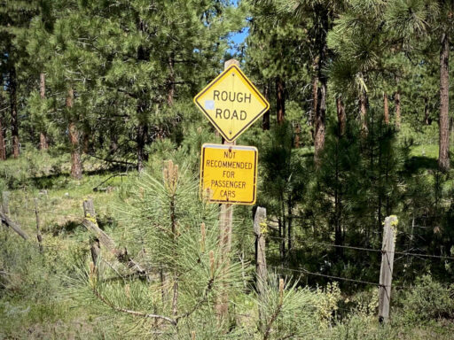
At mile 11, you come to a “Rough Road” sign. Surprisingly, the next 5.5 miles had the best quality gravel of the day. Hard-packed, smooth, and fast.
The road gradually climbs with the steepest and most rugged section near the summit at mile 17. From the summit on, expect chunky coarse gravel as the route parallels Beaver Creek until the next major gravel road.
Of note, at mile 19 you pass through a high alpine prairie, and in the distance are Vinegar Hill and Olive Butte.
Mile 23 to 31 / NF 13 / Gravel to Paved
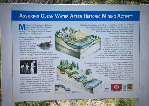
At ~ mile 23, make a right onto NF 13 a proper gravel road. It is hard-packed, fast, and slightly downhill. From here it is 6 miles to Granite. At mile 25 the road turns to pavement. This marks the spot of a kiosk on the left side of the road that talks about the mining days and the current ecological clean-up (i.e. those psychedelic red settling ponds you see).
This also marks the turn to the Fremont Powerhouse. “The powerhouse was constructed in 1908 and after 59 years of continuous service, generated its last electrical power in October 1967. The need for power surfaced in 1903 when the earnings of some local mines began to decrease. In an effort to operate the mines more economically, local waterpower was piped from nearby Olive Lake though an eight-mile long wood and steel pipeline to generate the much-needed electrical power.”
Miles 31 to 48 / Bull Run Climb & Descent / paved
Mile 31 marks the town of Granite. From here the terrain is relatively flat with a few scattered homesites until mile 32 where you re-enter the national forest and the road pitches up. The climb in total is 1200 feet of gain, with moderate gradients of 4 to 5%.
In the mid and late 1800s, the North Fork John Day drainage was bustling with gold and silver mining. In the rush, mining towns popped up here and there, only to be left to ruin as the mining dwindled. The nearby town of Granite is one such ghost town, with weathered buildings and the graves of prospectors and pioneers who came to seek their fortunes.
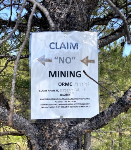
For most of the climb, the road follows Bull Run Creek where there is evidence of tailings from past dredge mining. There are still some active mining claims, as marked by the postings on trees with names like Bull Magic, Bull Run 2, and Bull Power.
At mile 40.5 the climb tops outs. The descent is steeper than the climb dropping 1200 feet in 4 miles making is super fun. The last 3 miles into Sumpter are slightly downhill but still fast.
When We Like to Ride This
Late spring through summer when the flowers are in bloom, the creeks are running full, the grasses are green and the peaks are snow-capped. However, the route will also ride well into the fall. This is also a good go-to route on a cloudy day as a majority of the visual return is near distance and intimate.
Terrain & Riding
Before even taking off on the ride, spend some time in the park learning about the Sumpter Dredge and the history of gold mining in the area. We toured the Sumpter Dredge and walked along the paths reading each of the kiosk posts.
“The dredge in the park is the last of three built on the Powder River. Built in 1935, it ran until 1954. It dug up more than four million dollars worth by a simple, but dramatic method.
Sticking out from the dredge’s hull is a massive boom bearing 72 1-ton buckets. The buckets, moving like the chain of a chainsaw, would bore into the riverbank and carry the loose rock back into the dredge interior.
Once inside, the rock would pass through a series of steel cylinders to separate the material by size, sending the smaller material deeper into the dredge. Using water and sluices, the gold would be separated from the sediment. The spoils from this process and larger rock pass through the back of the dredge and are deposited behind it via another boom.”
The Start
Sumpter Valley Dredge Heritage Area. Visitor Center, flush toilets, and water.
Food & Water
- Services in Granite (~ mile x) include the Granite Outback General Store and The Lodge at Granite. We recommend that you verify these services are still in place before relying on them.
Route Notes
We recommend a red blinky light with rear looking radar detector (i.e. Garmin Varia)
Route Options
The ride can be shortened to 32 miles, with 3000 feet of gain, and ~ 25 % paved by going right at mile 16.5. The trade-off is that this option does not include the visit to the Fremont Powerhouse and the town of Granite.
Videos
The Ride! The Dredge
A quick 2-minute video of what to expect on your ride!
How a Dredge Works
Even for Caption O of Dirty Freehub, it took a bit to understand how a gold dredge works. Here's a quick explanation.
The Sumpter Gold Dredge
The Sumpter Valley Gold Dredge is one of the last remaining giant gold dredges in the US. In this 10-minute video learn a bit about the history, current status, and how the dredge worked.
Podcasts
Mining Gold in the Blue Mountains
Learn a little about the gold mining history in the Blue Mountains, from dredge mining to hard-rock mining to some of the clean-up efforts.
Granite, Oregon (The early history)
A short micro-cast with Kevin English, one of the founders of Dirty Freehub, where he talks about what he learned of the early history of Granite, Oregon. A small town in the NE quadrant of the state.
Ridden and Reviewed by:


Have you ridden this route? Got a question? Join the discussion!