Apex Mine


Highlights & Remarkable Spots
Paiute Indian Homelands / ~ the entire ride area
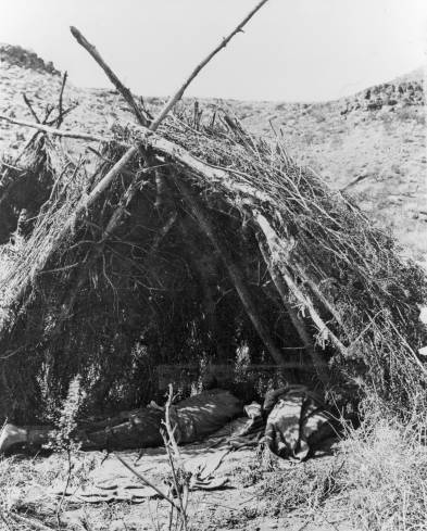
The lands where St. George, Utah is now located were first inhabited by the Paiute Indians. The first recorded contact between Utah Paiutes and Europeans occurred in 1776 when the Escalante-Dominguez party encountered Paiute women gathering seeds. In 1826-27 Jedediah Smith passed through Paiute country and established an overland route to California. Trappers, traders, and emigrants on their way to California soon followed. The increased presence of Europeans and their animals had serious effects on the Paiutes. The animals of the emigrants ate the grasses and often the corn that served as food for the Paiute. Photo of a Paiute Wickiup. Wickiups were simple huts covered with brush. [Utah.gov]
Bloomington Cave / ~ Mile 8
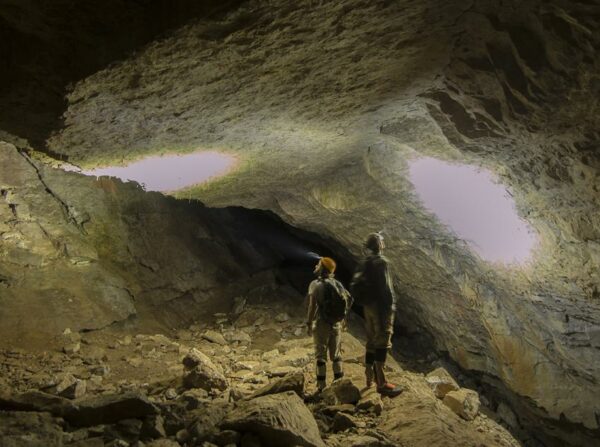
The Beaver Dam Mountains, located in the southwest corner of Washington County, Utah, are primarily composed of Permian Age limestone, which is ideal for rock climbing and supports the creation of fascinating cave systems. Among these, Bloomington Cave, a large tectonic cave with six distinct levels and narrow passages, stands out as the most extensive and renowned in the area.. With a surveyed length of 1.43 miles (7,574 feet), Bloomington Cave is Utah’s fifth longest cave. Its significance led to its designation on federal lands under the Federal Cave Resources Protection Act of 1988. Despite its challenges, such as crawling, squeezing, and slippery surfaces, Bloomington Cave remains a popular destination for adventurous explorers. [BLM]
The Apex Mine / ~ Mile 10.5
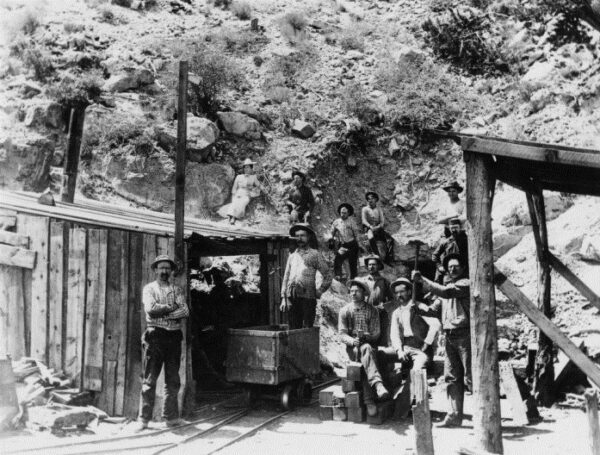
The Apex mine, a significant copper producer in Utah, was operational from 1884 to 1962. The mine produced over 7000 metric tons of copper, 180,000 troy ounces of silver, and small amounts of gold, lead, and other minerals. After a period of low production, the mine was acquired by Woolley, Lund, and Judd in 1890, who established a profitable enterprise by constructing a smelter in St. George. The mine experienced ups and downs, and the Utah Eastern Copper Company purchased it in 1898, building a smelter near Shem on the Santa Clara River. Declining copper prices led to the closure of the Shem smelter in 1907. Despite the fluctuations, the mine remained a valuable source of minerals, including aurichalcite, malachite, smithsonite, lead, and silver, traces of which can still be found in the closed mine’s tailings today. [WCHS Utah]
Bloomington Petroglyph Park / ~ @start/finish
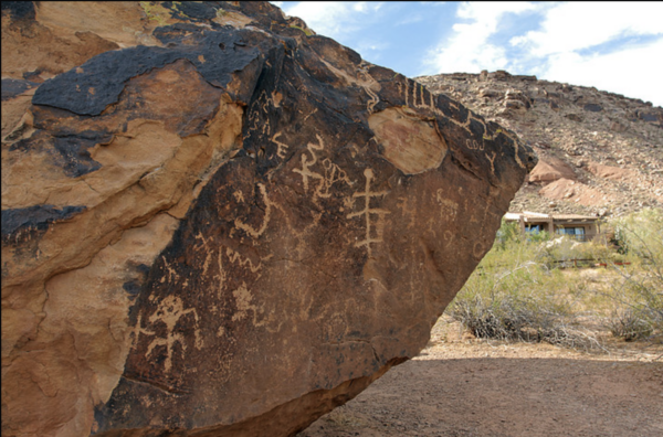
This .5-acre rustic park highlights large boulders with petroglyphs. The carved images left behind on the rocks tell the stories of ancient peoples. Many of these carved images are recognizable as human and animal forms and perhaps early trail maps. Help us preserve this unique and fragile cultural heritage. Look and observe but do not touch. Make a quick stop pre or post ride; you can find the petroglyph park on the northeast corner of Geronimo Road and Navajo Drive. [The City of St. George]
Credits & Acknowledgements
A big shout out to Rapid Cycling Bikes for sharing this route with us.
When We Like to Ride This
Like most rides in the St. George area, this ride puts you in full sun exposure from start to finish. So in the colder months, it’s a great late morning to afternoon ride as the temperatures warm up. In the warmer months, get started early to avoid the mid-day heat.
Terrain & Riding
You’ll roll out from the Bearclaw Poppy Trailhead, sharing the first bit of gravel road with a variety of OHV (Off Highway Vehicles) if you happen to be venturing out on a weekend or holiday. Once you make it to the split at the 2-mile mark, you’ll begin weaving through dried washes and eventually begin the long climb up past the Bloomington Cave into Mine Valley. The gravel will vary from smooth, to sandy, to chunky and everything in between to keep you on your toes as you climb and eventually rip down a well-earned and long descent.
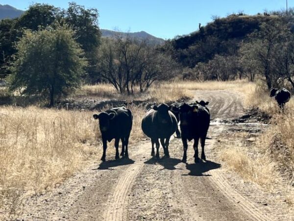
The terrain you’ll encounter on this route will be typical of Southwest Utah, with the exception of the rare and fragile gypsum soil crust that provides the specific environment for the endangered Dwarf Bearclaw Poppy, which only grows in this tiny part of the world. The route starts in the exposed red earth where you weave through washes surrounded by scrub brush, low-lying shrubs, and cacti. Keep an eye out for the Dwarf Bearclaw Poppy in the first and last quarters of your ride. As you climb to higher elevations near Bloomington Cave and the Apex mine, the washes and red earth will give way to more open grazing areas with wild grasses, Utah Juniper, Pinyon Pine, and free-ranging cattle. Be sure to take some water breaks and look back at all you’ve climbed, as well as the stunning geological rock formations of the St. George area.
The Start
Dirt parking lot at Bearclaw Poppy MTB trailhead. Pit toilets.
Lat / Long: 37.0522271, -113.626082
Food & Water
- None.
Route Notes
You may encounter free-raning cattle on this ride. Please take a moment to review the resource page on cows and how to pass by them safely and with regard to ranchers.
You may encounter other user groups, such as OHVs, rockhounds, and hobby miners in the area. We encourage you to stop and share a story with them but most importantly, share the trail. #ShareTheTrail
Route Options
At mile 10.5, if you’ve got gas left in your legs and want to visit this route’s namesake, you can hang a right on Old Apex Mine Road for an additional 1.5 mile, 550 foot climb up to the abandoned Apex Mine. Spend some time collecting colorful blue azurite and green malachite in the mine’s tailings piles before descending back to the main route.
For a longer route option (39 miles) that incorporates part of this route, check out the Apex Mine route by Rapid Cycling Bikes.
Love Where You Ride! Learn More
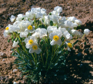 The endangered Dwarf Bearclaw Poppy is only found in this unique and fragile ecosystem. You’ll be riding through the habitat of the endangered dwarf bearclaw-poppy. This species, which is found only in Washington County, Utah, grows in unique and fragile gypsum soil on steep, exposed hillsides and ridges. The gypsum soil crust that supports the plant can take up to 250 years to fully recover from damage, making protection critical. This area is preserved as a Area of Critical Environmental Concern by the Bureau of Land Management. It’s critical that you stay on designated trails during your ride. #LeaveNoTrace
Videos
Exploring Bloomington Cave
Exploring Bloomington Cave in the St. George area of Southern Utah. Don't watch if you're claustrophobic!
Rockhounding Minerals at the Apex Mine
If you are a rockhound, watch this quick 2-minute video! In the tailings of the old Apex Mine, there are some beautiful rocks with blue Azurite and green Malachite.
Be Informed!
Keep it Local! Learn More

Ridden and Reviewed by:

Have you ridden this route? Got a question? Join the discussion!