Gibraltar Road


Highlights & Remarkable Spots
Old Mission Santa Barbara / ~ mile 1
“Old Mission Santa Barbara was established on the Feast of St. Barbara, December 4, 1786 by Fr. Fermin Francisco de Lasuen, and was the tenth of the 21 California Missions to be founded by the Spanish Franciscans.”
Gibraltar Road / ~ mile 3
A massive paved climb up the Santa Ynez Mountains with stunning views of Santa Barbara and the Pacific Ocean followed by a beautiful dirt descent down to the Santa Ynez River.
Gibraltar Dam / ~ mile 16.5
Gibraltar Dam meets you at the bottom of Gibraltar Road where it’s been serving the Santa Barbara area in various forms for over one hundred years. It dams the Santa Ynez River and makes the Gibraltar Reservoir. “The Gibraltar Reservoir is the source of about one-third of the City of Santa Barbara’s water supply during a normal water year.”
Santa Ynez River / ~ mile 17
As you ride down Paradise Road you get a close-up glimpse of the Santa Ynez River (if it’s flowing) and the exposed rockfaces that line it. “It is one of the largest rivers on the Central Coast of California. It is 92 miles long, flowing from east to west through the Santa Ynez Valley, reaching the Pacific Ocean at Surf, near the city of Lompoc.”
Arroyo Burro Road / ~ mile 23.5
The gorgeous but grueling dirt climb back up to East Cielo Camino Road. You’ll be climbing mostly into the sun, but luckily it swings around enough so you get views of all your surroundings.
Chumash Painted Cave State Histoic Park / ~ mile 35
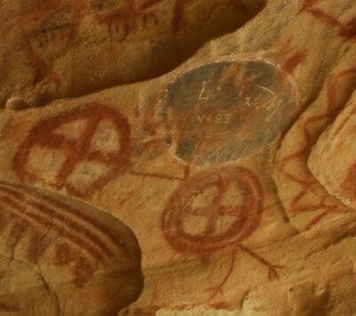
This cave holds some of the last remaining wall art painted by the Chumash people.
“The tradition of passing down the meanings of the cave paintings has largely been forgotten over the three hundred years since European colonization; however, several interpretations have been argued. In 1677, the area around Painted Cave experienced a total eclipse and two of the brightest stars in the sky, Mars and the red supergiant, Antares, created a triangle with the sun. Argued to have been documented, the black circle is said to represent the total eclipse, the “star” with legs would have represented Mars, as a “wandering star,” while Antares is on the right.”
Due to the iron gate that protects the paintings, it can be challenging to fully appreciate them. You can find more information and get a closer look with this 3D Explorer.
San Marcos Road / ~ mile 37
The best part of the descent off East Camino Cielo Road with a beautiful sparkling ocean backdrop.
Credits & Acknowledgements
This route is published in cooperation with Gravel Bike California and Zack Rynew. A big shout out to them!
When We Like to Ride This
Enjoyable all year round, especially on clear days to best enjoy all the views. We would avoid windy days due to the amount of descending on narrow windy roads. It could get busy on the paved Gibraltar Road section so we would try and avoid the weekends and holidays. You will cross the Santa Ynez River 5 times, please check to make sure Pleasant Road is open before you go. “The river’s flow is highly variable. It usually dries up almost completely in the summer, but can become a raging torrent in the winter.” [Wikepedia]
Terrain & Riding
You start off on city streets and don’t have to wait long to begin the climb up Gibraltar Road. It feels longer than its listed 6.1 miles, but the 8% average gradient and big views have a lot to do with that. After Gibraltar Road merges with East Camino Cielo at the top of the climb, the route indiscriminately veers off a half-mile later for the start of your off-road adventure. It starts out with a seven-mile descent on fire roads in great condition.
You have another three miles of dirt after the descent which involves some climbing. The fire road then spits you out for four miles of pavement which is a nice opportunity to catch your bearings before the next big climb ahead. That climb, Arroyo Burro Road, is a steady 5.3 miles averaging 6.9% on dirt, which makes it as hard as Gibraltar Road, even with its above-average dirt road conditions.
At the top, you again reach East Camino Cielo and climb the last mile and a half on pavement. Finally, you get to cash in that climbing with a fun, ridge-riding two-and-a-half-mile descent flipping between views of the Santa Ynez River and the Pacific Ocean. Then you cross the busy Highway 154. On the other side of the highway, the street turns into San Marcos Pass Road where you’ll have the chance to pick up the most downhill speed of the day. Then your ride ends with a few miles of surface streets.
The Start
The parking lot of Handlebar Coffee Roasters.
Food & Water
- ~ start of ride / Handlebar Coffee Roasters
- ~ mile 24 / Lower Oso Picnic Area - Instead of turning off Paradise Road onto Arroyo Burro Road at mile 23.7, continue on Paradise Road for 1 mile until you arrive at Lower Oso Campground. There are flush toilets and potable water.
- ~ mile 34 / Cyclist-Friendly House - The house puts out a water jug and water bottles. Please don't count on it for resupplying because we do not know how often it is restocked or the house's exact location. All we know is that it is around mile 34.
- ~ mile 41-45 / Various Restaurants
Route Notes
These roads are narrow and twisty with many blind corners. Please be aware of descending riders and cars especially on Gibraltar Road. When descending please be courteous to fellow road users, check your speed, and stay in your lane.
There may be equestrians on Arroyo Burro Road so please yield and communicate to the riders about how to proceed, the riders are always super friendly!
In National Forests eBikes are only allowed on roads that are legal for powered vehicles. Gibraltar Road’s dirt section and Arroyo Burro Road are closed to powered vehicles so they are not legal for eBikes.
I rode this on a Salsa Warbird with Rene Herse Oracle Ridge 48mm tires, they were awesome. You could absolutely tackle this route on less rubber; 35mm and up should be just fine for Dirt Gibraltar and Arroyo Burro.
We recommend a red blinky light with rear looking radar detector (i.e. Garmin Varia)
Videos
The Ride! Gibraltar Road
A quick 2-minute video of what to expect on your ride!
Ridden and Reviewed by:


Have you ridden this route? Got a question? Join the discussion!