Winter & Summer


")


")


Caution! We do not provide turn-by-turn directions in our GPX files. Those are auto-generated by your bike computer and are usually less than 70% accurate. Learn more.
For help loading a GPX file onto your bike computer, go here.
DownloadHighlights & Remarkable Spots
Winter Ridge Climb / Gravel / ~ Miles 0 to 9
Few rides start out as beautiful and as demanding as this one. The first miles provide sweeping views of the Summer Lake Basin. The higher and longer you climb, the more infrequent the views become. Near the top, you are mostly in pine forest. Ohh, the climb! 8.5 miles with 2500 feet of gain, at a grade of 5 to 8% the entire way.
The road is hard-packed gravel with a slight layer of pea gravel. At mile 7.6, at a strong left bend in the road, there is a viewpoint worth stopping at.
Sycan River / Gravel & Broken Pavement / ~ Miles 9 to 14
From the summit, you drop a few hundred feet (quickly) on gravel and then make a left turn onto NF-28. The next 3 miles are on broken pavement with spots of gravel and divots. To your right is the Sycan River, which has been designated Wild and Scenic. In the spring, the area is green and lush, and flower filled.
The Sycan River is a tributary, about 71 miles long, of the Sprague River, which flows into the Klamath River in Oregon. Its headwaters are in highlands in the Fremont National Forest south of Summer Lake.
The river corridor contains a diversity of landforms, from steep canyon walls to open plains. The vegetation is primarily old-growth ponderosa pine and lodgepole pine flats intermingled with water-related riparian vegetation, such as willows. Expanses of sage and bitterbrush in the dryer areas lend diversity.
The river supports rainbow, brook, brown, and bull trout and provides wetland habitat for Sandhill cranes, bald eagles, and waterfowl.[Wikipedia and National Wild and Scenic River Systems]
NF-332 & Freemont Connector / Double-Track & Primitive Dirt Road / ~ Miles 14 to 23
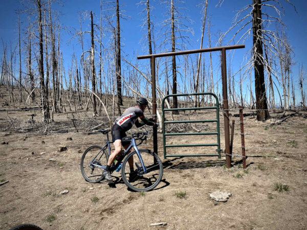
This is the crux sector of the day — and one of the most beautiful and diverse sectors of the day. The track is a single-wide primitive road, double-track, and at times almost indiscernible. The tread varies from rocky and lumpy, to soft, to loamy forest cover. The scenery is that of a blackened and charred forest, vista views of the Summer Lake basin, and lush meadows along Bear Creek.
- Go the viewpoint at mile 17.5, it is well worth it;
- To pick up the route (the Fremont Connector) after returning from the viewpoint at mile 18.5, look for the green gate, and;
- For miles 18.5 to 22.5 you will be paralleling the Oregon Timber Trail (Fremont Tier).
NF-331 Downhill / Gravel / ~ Miles 23 to 30
After popping out onto NF-331 from the Fremont Connector, you turn onto a wide two-lay proper gravel road. Climb a short hill and then begin a 6-mile descent with a modest average grade of 3.5%. Just perfect for fast and fun.
As you descend, the views open up; the town of Paisley is directly in front of you. This is also the area of the summer fires of 2020.
NF-336 / Gravel / ~ Miles 30 to 44
Without expectation, this was one of the most enjoyable sectors of the day. Hard-packed gravel, a couple of rolling hills, a wahoo! finishing descent, a picturesque viewpoint, and a hidden lake.
When We Like to Ride This
June through October. From mid-June to July, the flowers are in bloom, and the grasses are green. In October, you get the fall colors with the leaves changing. Before June, you can hit several wet, boggy, and muddy areas where it may be impassable.
Terrain & Riding
The ride begins with a long, continuous climb of 8 miles to the crest of Winter Ridge. Then, after a short respite, tackle 9 miles of rugged double-track riding through high-alpine meadows and an eerily beautiful, deeply burned forest. Wind out to a ridge viewpoint with a jaw-dropping view of Summer Lake and finish out with some rolling terrain, a hidden lake, and a blasting fun downhill.
The Start
A makeshift dirt pull-out off of Highway 31 by about a mile: follow NF-3313 to a bend in the road with a parking area and nice views of the valley below.
Food & Water
- None.
Route Notes
40 mm tires or larger. Some people may prefer a wider tire for the NF-332 & Freemont sector, but it is completely rideable with 40 mm tires by a skilled gravel cyclist.
There is open grazing along the route, exercise caution around blind corners. Don’t T-Bone into a steer. Bad day!
This area has seen significant wildfire in the last few years. Thus, expect stands of burned forests along with salvage logging operations.
Get Involved!
 We found Summer Lake to be exquisitely beautiful and would encourage you to learn more about the lake and conservation efforts by the Oregon Desert Land Trust.
Videos
The Ride! Winter & Summer
A quick 2-minute video of what to expect on your ride!
Ridden and Reviewed by:


 Behind every route is scouting, mapping, storytelling, and a whole lot of pedal power.
Have you ridden this route? Got a question? Join the discussion!