Washington Gulch


Caution! We do not provide turn-by-turn directions in our GPX files. Those are auto-generated by your bike computer and are usually less than 70% accurate. Learn more.
For help loading a GPX file onto your bike computer, go here.
DownloadHighlights & Remarkable Spots
The Old Churchill School / ~ Miles 0
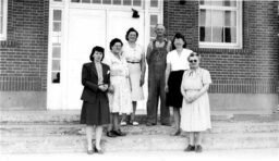
A one story brick elementary school with six rooms and a basement was built in 1926 and is named for former superintendent J. A. Churchill. A wing and gymnasium-cafeteria were added after 1960. Today the school is home to an arts hub, a dancehall, a bike hostel and high-end AirBnB. Have a listen to our podcasts with the owners Brian and Corrine.
Powder River (Bowen Valley) / ~ Miles 2.6 to 4.6
From the mid to late 1800s the Powder River Valley was home to placer gold mining and timber harvesting.[US Forest Service] The Powder River runs from the town of Sumpter (east of Baker City) to the Snake River.
Long before the arrival of pioneers and settlers, the Cayuse, Umatilla and Nez Perce Indians utilized the hunting and fishing grounds along the length of the Powder River. In this area are archaeological sites which contain important information about the use of local lowland areas during the prehistoric middle archaic period.[National Wild & Scenic River System]
Elk Creek / ~ Miles 8.5 to 10.5
Along this 2-mile sector you ride by a beautiful flowing creek with current mining claims and some old mining equipment. The creek had produced considerable amounts of placer gold.
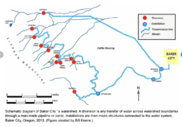
Watershed High Point / ~ Miles 13
At the settling tank here, two of the three water transmission lines for the city of Baker converge and deliver water to Baker City. From this high-point you also get some big views of the Wallowa Mountains to the northeast. The range runs approximately 40 miles northwest to southeast and is known as the “Alps of Oregon”. What is unique to the range is that unlike most of Oregon, the range is granite versus basalt.[Wikipedia]
Old Washington Gulch Road / ~ Miles 13 to 18
This 5 mile sector roughly follows the old Washington Gulch road. It is believed the actual routes was a bit to the right of the course we have mapped. Circa 1865, the Washington Gulch Road was the major transportation thoroughfare between Baker City and Auburn, a gold mining boomtown that was once the largest town in Eastern Oregon. The road avoided the swampy Bowen Valley south of Baker City where the present-day Highway 7 is.[Four Founding Fathers of Baker City]
Credits & Acknowledgements
Route by Brian Vegter co-owner of the Churchill School – a bike hostel, arts hub, dance hall and high-end AirBnb.
When We Like to Ride This
Late spring and fall are stupendous times to explore Baker County on variable surfaces. And summer is not bad also.
Terrain & Riding
A ride bookended by farms and ranches with the middle third being dirt Forest Service roads that are rugged and demanding. Expect some steep descents in excess of 14% and expect to work. Even though the route is short, it gains 2100 feet.
The terrain is a mix of boggy, green marsh lands along the Powder River, rolling grasslands with high desert scrub, forest (some thinned and logged, some with old trees dripping with moss) and valley ranches and farms.
The Start
Food & Water
- None.
Route Notes
We recommend a red blinky light with review radar detector like a Garmin Varia, especially for the first couple of miles on Highway 7. Use caution.
The route can be ridden in both directions, but as mapped, this direction has less demanding climbing (short pitches of 10%+ in lieu of 20%+).
Much of this route is rural, but mile 9 to 18 are remote and within the National Forest.
Love Where You Ride! Learn More
![]() A really cool place to stay in Baker City is the Old Churchill School. They cater to cyclists with a hostel, high-end B&B, art hub and live concert venue.
A really cool place to stay in Baker City is the Old Churchill School. They cater to cyclists with a hostel, high-end B&B, art hub and live concert venue.
Videos
The Ride! Washington Gulch
A quick 2-minute video of what to expect on your ride!
Podcasts
Tractors, Bulls and Lycra
In this podcast, we talk with Daarla K who is a rancher and farmer in northeast Oregon. She and her husband operate a 1000-acre farm that has been in his family since 1886. Learn how to safely pass by big tractors and combines, how to get through a cattle drive, and what aggressive behavior [...]
Ridden and Reviewed by:


 Behind every route is scouting, mapping, storytelling, and a whole lot of pedal power.
Have you ridden this route? Got a question? Join the discussion!