Steens Mountain Tour


Day 0
Drive to Crystal Crane Hot Springs. Each tent location has access to the beautiful high desert views and individual fire pit. Showers, restroom, camp kitchen, and commons area just a short walk away.
- Lodging / Camping: Crystal Crane Hot Springs. Contact them for vehicle storage. They charged $5 per car per night.
Day 1: Crane to Ten Cent Lake
A shorter day with the opportunity for all bike packers to adjust and tune their gear.
- Water: None.
- Breakfast: Crane Store and Cafe. The Cafe is open 7a-7p at this time. Contact them in advance to make sack lunches.
- Lunch: Packed from Crane Store and Cafe
- Dinner: Self supplied.
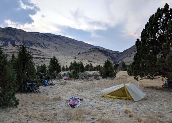
- Camping: All around the lake is BLM. Cannot camp east of the road. Dispersed Camping rules: (a) Choose sites that are already established (b) Use existing fire rings. (c) Dispose of human waste properly (away from water and in a 6” or deeper hole). Call Burns District Office 541-573-4400 to verify dispersed camping rules and fire conditions.
Day 2: Ten Cent Lake to Fields
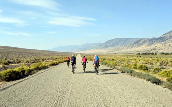
Pavement ends at mile 4 and picks back up again at mile 45. Expect amazing views. To the east is the Alvord Desert, used by wind-driven sail car enthusiasts. Pass Alvord Hot Springs (mile 35, $5 for gallon of water, $8 to soak).
- Water: mile 42 at Andrews School. Contact artist John Simpkins. He is hospitable to cyclists and can be found on Facebook to arrange for water.
- Breakfast: self-supplied
- Lunch: self-supplied
- Dinner: Fields Station. The grill closes at 4:00p and the cafe stops taking orders at 3:30p. Call in orders at 541-495-2275 to beat the closing time. They are punctual. “Because we’re really in the middle of nowhere, Fields Station has a bit of everything. We have a store, a café, a hotel, gas, liquor and a post office. We’re most popular for our burgers and shakes. Our milkshakes are so good because we don’t use any milk.”
- Lodging / Camping. Shaded bike tent area is on the left, south of the Fields Station. They have also let cyclists pitch tents behind the store. No charge for camping. Vaulted toilets and a frost free hydrant by the shade tree in the center available for campers. Call for a limited supply of motel rooms.
Day 3: Fields to Frenchglen
A morning wake up to a climb after little warm up summiting in 7 miles, after which it is nice, paved, ride into Frenchglen. Roaring Springs is on the way, named after the peculiar noise made by the seeping waters you hear as you ride by.
- Water: mile 37 at Roaring Springs Ranch / Airport. Andrew at 541.495.2263 has been kind to cyclists letting them get some water and rest in the shade.
- Breakfast: at The Fields Station, starting at 8 am. They can make a sack lunches.
- Lunch: sack lunch from Fields Station.
- Dinner: 6:30 pm, family style.
- Lodging / Camping at the Frenchglen Hotel. Small bike tents for cyclists can go on grass behind the hotel. They can make a sack lunch. BLM’s Page Springs Campground is an alternative.
Day 4: Frenchglen to Frenchglen via the Loop Road
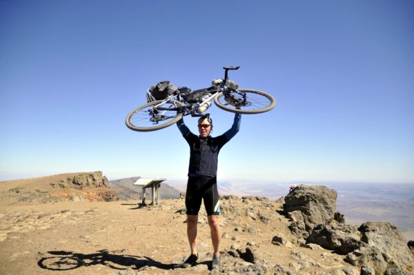
With bike packs left behind, take a light-weight ride up and into the Steens. Summit the peak after a 17 mile climb, and then back downhill, with pavement picking up again by mile 60. Take in views several of the area’s almost perfect examples of glaciated U-valleys, including the breathtaking Kiger Gorge.
Beginning in Frenchglen, the Loop Road has something to offer for all abilities, from out-and-back rides up to Fish Lake and Jackman Park, to viewing the textbook U-shape glaciated Kiger Gorge, and to my favorite the East Rim Overlook. The full loop is a long day of serious gravel cycling with more than 7500 ft in elevation gain. An early start is recommended, and for us that meant sharing the road with surprised deer. The payback for the many miles of climbing is the steep downhill back to Frenchglen. Road apple hinted at another reward with wild horses appearing on the downside.
Captain “O”, Gravel Girl and many from the Dirty Freehub Team did this as a one-day ride in July of 2018. Click here for their route description.
- Water
- mile 17 at Fish Lake Campground. Water is a ways in.
- mile 19 at Jackman Park Campground. Quick access with the pump close to the road.
- mile 42 at South Steens Campground. Good water.
- Breakfast: Frenchglen Hotel starts at 7:30 am. A dry breakfast and lunch from the Mercantile Store for an early departure works well depending on your goals.
- Lunch: packed from the Frenchglen Hotel or the general store.
- Dinner: Family style diner at 6:30 pm
- Lodging / Camping at the Frenchglen Hotel. Small bike tents for cyclists can go on grass behind the hotel. They can make a sack lunch. BLM’s Page Springs Campground is an alternative.
Day 5: Frenchglen to Crane

Not quite a recovery ride, but easier, all paved, a day after the toughest. Pass by Malheur National Wildlife Refuge, the Diamond Craters volcanic field, and French’s Round Barn, constructed in the 1870s, where 300 – 1000 horses were tamed annually.
- Water: mile 34.5 at French’s Round Barn convenience store
- Breakfast: 7:30 am at the Frenchglen Hotel.
- Lunch: packed from Frenchglen.
Route Notes
Hazards
- Ticks, mosquitoes (Frenchglen area), and rattlesnakes in spring and summer.
- Goat’s Head (Tribulus Terrestris). Also known as puncturevine: limited distribution in The Steens. None observed.
Road Conditions
Contact John Eden (john.w.eden@odot.state.or.us, ODOT District 14 Access, 541-823-4016) for OR78 & OR205. For info on Diamond Lane, Diamond Crater Road, and Fields Denio, contact the Debbie Cronin (debbie.cronin@co.harney.or.us, Harney County Road Master’s Office, Burns, 541-573-6232).
Ridden and Reviewed by:

 Behind every route is scouting, mapping, storytelling, and a whole lot of pedal power.
Have you ridden this route? Got a question? Join the discussion!