Dirty Freehub
Favorites Sign In Search
  • Search
  • Donate
  • Gravel Routes
    • Explore by Region
    • Explore by Type
    • Explore by Collection
  • All Access®
  • Stories
    • Bike Life
    • Culture & History
      • Central Oregon
      • NE Oregon
      • Bend Trails
      • Death Valley
    • People & Places
    • Lands
      • Arizona
      • Central Oregon
      • NE Oregon
    • Love Where You Ride
  • Events
  • User Guide
    • Route Types
    • How We Rate Routes
    • Using the Map
    • Loading a GPX File
    • Glossary
    • FAQs
  • Inside DF
    • The Team
    • Our Missions
    • Impact Reports
    • Press
    • Sponsors
  • Store
    • Gravel Guides
    • Merch
  • Donate
  • Cart
  • Sign In
  • Favorites

Owyhees Tour

Bikepacking Route / Southeast, Oregon / Published: Sep 2020 / Directions
Save to Favorites Remove from Favorites
Waking up from star-filled skies. Owyhees Tour / September 2020.
The first climb is just 5 miles from town. A 2 mile, 6% grade, rewarded with first views of the Owyhee Mountains. Owyhees Tour / September 2020.
The geography of the Owyhee Mountains is noticeably different from the volcanic Owyhee Desert and River. Owyhees Tour / September 2020.
Precious metals found in 1864 made Silver City prominent in the region. Now a 'ghost' town with recreational inhabitants. Owyhees Tour / September 2020.
The Idaho Hotel restored in 1972 relies on propane refrigerators and stoves, and has a cobbled together look. Owyhees Tour / September 2020.
Just after Silver City there is a 1 mile 8% climb. Owyhees Tour / September 2020.
Leaving the Owyhee Mountains involves descending on a 6 mile 8% curvy road. Owyhees Tour / September 2020.
The pay-back - a view into the Snake River Plain after the final climb of the day. Owyhees Tour / September 2020.
The day ends with 25 paved miles on Highway 78 where there is low traffic density. Farm vehicles pass at high speed with a wide berth. Owyhees Tour / September 2020.
The transit back to gravel into the Owyhee Mountains and Desert. Owyhees Tour / September 2020.
The 29 mile grade to Summit Springs Saddle climbs 4000’ culminating in a 9% grade. Owyhees Tour / September 2020.
Between wildernesses on the curl-leaf mountain mahogany savannah. Owyhees Tour / September 2020.
Owyhee Uplands Backcountry Byway. Owyhees Tour / September 2020.
Horses of the Owyhee. Antelope is more common. Owyhees Tour / September 2020.
Deep Creek dispersed camping site. Owyhees Tour / September 2020.
Our water bottles had become blocks of ice overnight in a hard freeze. Even my shoes were frozen. Owyhees Tour / September 2020.
We experienced the love-hate relationship the pioneers on the Oregon Trail developed with sagebrush as we constantly fed the fire with this rapidly burning fuel. Owyhees Tour / September 2020.
Foilage on the Owyhee Uplands Backcountry Byway turning. Owyhees Tour / September 2020.
Three cyclists approaching the Owyhee North Fork near the Oregon-Idaho border. Owyhees Tour / September 2020.
Some of the Owyhee Uplands Backcountry Byway appears cut out of bedrock. Owyhees Tour / September 2020.
The turn off from the Byway to Three Forks was heavily rutted. The smooth surface was unexpectedly the fastests segment. Owyhees Tour / September 2020.
...the road down into Three Forks is best suited for four-wheel drive vehicles or vigilant Subaru drivers with clearance and wherewithal.... Owyhees Tour / September 2020.
Soothing indulgence in Warm Springs Canyon three miles from camp - literally under the old military road. Owyhees Tour / September 2020.
Bring your long spoons or spoon-extenders to fully utilize these freeze dried meals. Owyhees Tour / September 2020.
The Three Forks confluence. Owyhees Tour / September 2020.
Leaving Three Forks on the 1.2 mile 12% grade. Owyhees Tour / September 2020.
The remarkable Owyhee River canyon - some refer to it as the Grand Canyon of Oregon. Owyhees Tour / September 2020.
Teased for some time biking along the Owyhee River canyon rim. Owyhees Tour / September 2020.
Gazing into the Owyhee River canyon from the overlook. Owyhees Tour / September 2020.
Resting place of Jean Baptiste Charbonnea. Owyhees Tour / September 2020.
With gravel you can never let your guard down - up next there can be ruts, washboard, sand, and sometimes your bike will disagree with your direction .... Owyhees Tour / September 2020.
Kevin and Genevieve's. Owyhees Tour / September 2020.
Scott's. Owyhees Tour / September 2020.
Ben's. Owyhees Tour / September 2020.
*
Route:
Loop | 225 mi
*
Gain:
14,000 ft
*
Surface:
75% gravel, 25% paved
*
Technical Difficulty:
Demanding
*
Navigation:
Straightforward
*
Locale:
Remote
*
Tire Suggestion:
40 mm+
*
Options:
---

The Owyhees Tour is a four-day, bikepacking route across the Owyhee Mountains, over the Owyhee Desert, and along the Owyhee River. Highlights include the ghost town of Silver City, the Owyhee Uplands Backcountry Byway, Three Forks Hot Springs, and herds of wild antelope. For a great narrative of the route, see this article in the Oregon Natural Desert Association.

The name of the river is from the older spelling of “Hawaii.” It was named for three Hawaiian trappers, in the employ of the North West Company, who were sent to explore the uncharted river. They failed to return to the rendezvous near the Boise River and were never seen again. Due to this, the river and its region were named “Owyhee.” [Wikipedia]

The Owyhee Uplands Backcountry Byway is the primary access to central Owyhee County. From there, many other roads and primitive vehicle routes access more remote areas, including four Wilderness areas and three Wild and Scenic Rivers …a high, rolling plateau blanketed with sagebrush and bunchgrass interspersed with pockets of Curl-leaf mountain mahogany. The landscape has the appearance of an African savannah … [Owyhee Uplands Backcountry Byway Guide, BLM]

Silver City was founded in 1864, soon after silver was discovered at nearby War Eagle Mountain (elev. 8,065 ft). The settlement grew quickly and was soon considered one of the major cities in the Idaho Territory. The first daily newspaper and telegraph office in Idaho Territory were established in Silver City … [Wikipedia]

Stations on the Skinner Toll-Road, were located ten or fifteen miles apart, a good day’s travel for a fast team. Many were crude one-room shelters, while others resembled fortresses set in expanses of ranchland. All provided sheds and corrals for stock, access to water, and camping facilities for travellers. Frequently, staple provisions were for sale, and at least one station-master kept a well-concealed barrel of whiskey which he would uncover for a price. … [Skinner Toll Road]

The road down into Three Forks is best suited for four-wheel drive vehicles or vigilant Subaru drivers with clearance and wherewithal … [Wild Owyhee]

Read More
Map
Brown = gravel / dirt road
Blue = single track
Red = paved road
Purple = paved bike path
GPX Download   Version 1.0
Days

Day 0: Staging

Travel to Jordan Valley. The Sunny Ridge RV Park is a good place to stage the tour from. There are showers, restrooms, and a laundry. The town has very few services. Supplies are available at Mrs Z’s and Rockhouse Coffee has a great espresso milkshake. We experienced no mosquitoes in September, but they are said to be plentiful in the summer. Contact them for vehicle storage on-site.

The Basque pelota ball court in Jordan Valley is worth a quick stop.

Day 1: Jordan Valley to Grand View

Ride with GPS GPX file

  1. The first 5 miles are paved.
  2. At mile 5 there is a 2 mile 6% climb.
  3. At mile 26 there is a 1 mile 8% climb.
  4. At mile 27 there is a 7 mile 8% descent.
  5. At mile 34 there is a 1 mile 6% climb.
  6. At mile 38 pavement picks up.

Notes

  • Cell service in Jordan Valley is for T-Mobile. In the Owyhee Mountains, there is no cell service until on the Snake River Plain side. West of the Owyhee Mountains, when one can see Steens Mountain, there appears to be some service for Verizon (minimal). We recommend using a cell service coverage map like that found in Gaia for up to date coverage.
  • In Silver City, one can purchase water at the Pat’s What-Not Shop, across the street from the Idaho Hotel. It is the only gift shop in town, has some cold drinks, snacks, souvenirs, and lots of good information. The hotel also has bottled water. It is not recommended to drink treated river water or tap water due to the extensive mining history in the area.
  • There are several VRBOs (Vacation Rentals by Owner) in Grand View and along the Snake River.
  • With no formal camping options in Grandview, PeteC reports that contacting the City of Grandview helped his group camp at the small city park located at the NE end of Main Street on the Snake River. The City Clerk can turn off the sprinklers and help ensure the restrooms, water spigots, and electrical outlet boxes are available.
  • Breakfast at the Snake River Diner.
  • Salinas Mexican Restaurant is on the ‘main drag’ in Grand View.
  • Grand View Grocer is a couple doors down from Salinas and a good resupply option.

Day 2: Grand View to Deep Creek

Ride with GPS GPX file

  1. The first 19 miles are paved.
  2. At mile 12, observe the Shoofly Oolite and optionally hike the trail. The hike is not strenuous and a mile round trip. Oolite (egg stone) is limestone composed of tiny ooids, which form when calcium carbonate precipitates in concentric layers around individual grains of sand. The limestone hills off to the west are deposits from ancient Lake Idaho which covered from present-day Hagerman, Idaho to Vale, Oregon.
  3. The First 29 miles are 4000 ft uphill with an average 3% grade. The grade gradually increases, ending in 3 miles of 6%, culminating in nearly 9%.
  4. The remainder of this segment gradually drops from 6000 ft to 5000 ft at Deep Creek.

Notes

  • No services beyond Grand View, including no cell service.
  • Camp at Deep Creek. Dispersed camping is on the west and south side of the bridge. Treat the water.

Day 3: Deep Creek to Three Forks

Ride with GPS GPX file

  1. At mile 25, the North Fork crossing of the Owyhee River has reliable water but must be treated.
  2. The descent into Three Forks is a 12% grade over more than a mile on a rocky surface. Although some segments can be ridden, it is recommended to remind yourself that you are descending on a fully loaded bike, so walking makes sense.

Notes

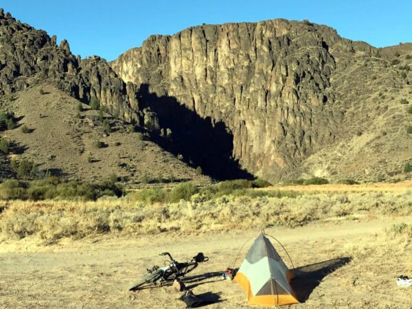
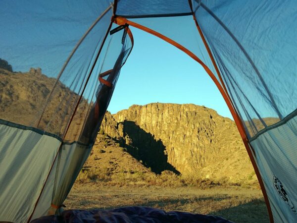
  • Camp at Three Forks. Dispersed camping. Treat the river water.
  • We did not experience mosquitoes in late September, but they are there in the summer.
  • Some goatheads observed.
  • The riverbank leading upstream for the campground and Three Forks Warm Springs are on unmarked private land. The owners have allowed camping and hikers to visit the warm springs – there is no guarantee this will always be the case – please respect the landowner’s rights.
  • No services.

Option 3a (spur): Three Forks Warm Springs

Ride with GPS GPX file

This is an optional spur to enjoy the warm springs. Just before the springs, one must ford the Owyhee. Footwear for the crossing is handy. Note that the flow of the river varies substantially with the seasons. Walking this section offers a nice break from cycling. The springs are on private land but hikers have been permitted and this can change – please respect landowner’s rights.

Day 4: Three Forks to Jordan Valley

Ride with GPS GPX file

  1. At mile 33, there is a 1-mile segment over the ION Highway. This highway has a 70 mph speed limit. Luckily, there is sufficient good-quality tarmac to cycle on to the right of the rumble strip.
  2. The last 4 miles into town are paved.

Notes

  • The overlook is spectacular.
  • One passes Danner and Innskip Station, resting place of Jean Baptiste Charbonnea.
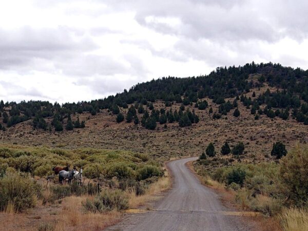
  • We saw many rattlesnakes on this segment.
  • No services until Jordan Valley.
Notes & Options

Route Notes

  1. Hazards

    • Ticks, mosquitoes, rattle snakes, and Mormon crickets.
    • Goat’s Head (Tribulus Terrestris). Only seen at Three Forks.
  2. Portland based retiree Bill Crowell has family ties to the Owyhee country and he curates the Owyhee Marginalia blog for an even deeper dive to exploring the region.

    Owyhee Trails: The West’s Forgotten Corner is a fun and colorful read. The author, who lives in Jordan Valley, is a 4th or 5th generation rancher with an encyclopedic knowledge of the area and it’s history.

Comments

Have you ridden this route? Got a question? Join the discussion!

Ridden and Reviewed by:

BenG

BenG / Team Dirty Freehub (Alum)

Ben was the first bike-packing guru at Dirty Freehub, publishing multi-day routes that he curated. He is also the creator and developer of the Bend Shorts series. (2018 – 2022)

Explore Similar Routes:

Ghosts

Sign Up for the Dirty Freehub Newsletter

info@DirtyFreehub.org
Terms of Service Privacy EEO Policy Our Values
Dirty Freehub is 501(c)3 non-profit organization.
©2025 Dirty Freehub :: All Rights Reserved :: Website Design
Cleantalk Pixel

We Need Your Support!

Dirty Freehub is a 501(c)3 nonprofit funded by generous donations from riders like you!

  • $25 Keeps the lights on (web hosting, technology tools, insurance, etc.)
  • $50 Keeps lights on + up to date route conditions
  • $100 Continued route development
  • $200 Fully documented route guide
  • $200+ Gravel Girl giggle of gratitude

Donate Today