Lostine Leap


Caution! We do not provide turn-by-turn directions in our GPX files. Those are auto-generated by your bike computer and are usually less than 70% accurate. Learn more.
For help loading a GPX file onto your bike computer, go here.
DownloadHighlights & Remarkable Spots
Lostine / @Start
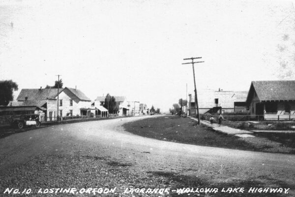
Established in the late 1800s during a wave of homesteading in the Wallowa Valley, the area attracted pioneers who were drawn to its fertile soil and abundant water from the Lostine River. These natural resources made it an ideal location for farming, with early settlers cultivating grains, vegetables, and hay to sustain themselves and their growing community. Livestock farming, particularly cattle and sheep ranching, also became a cornerstone of the local economy, with the vast open rangelands surrounding the town supporting the industry.
Zumwalt Prairie / ~ Miles 1-23
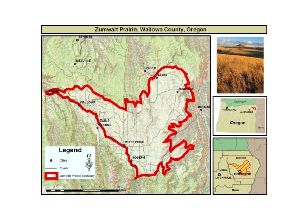
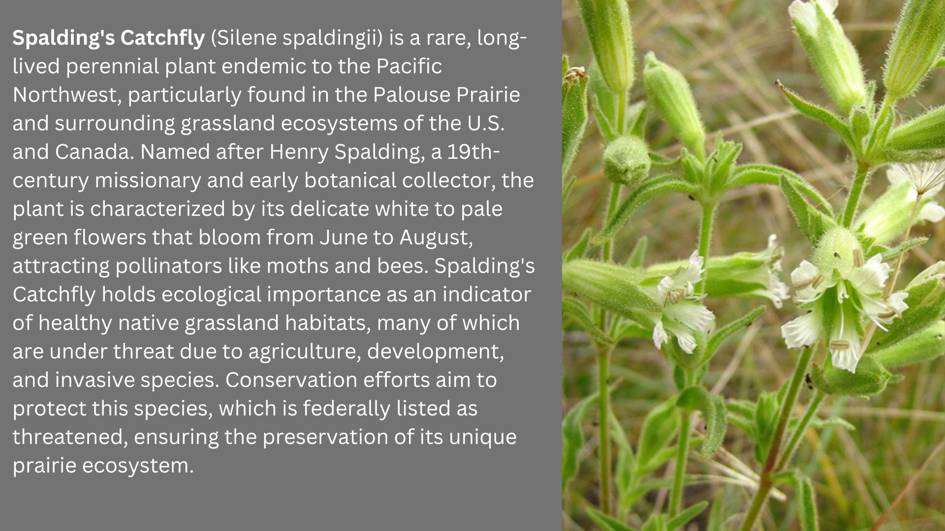
The portion of Zumwalt Prairie that this ride takes you through is now used for growing wheat and as grazing range for beef cattle in the spring, summer, and fall. Despite centuries of human use, the Zumwalt Prairie continues to provide a home for nearly all the plant and animal species that have survived here for millennia. It also supports the largest known population of Spalding’s catchfly.
Wallowa River / ~ Mile 4
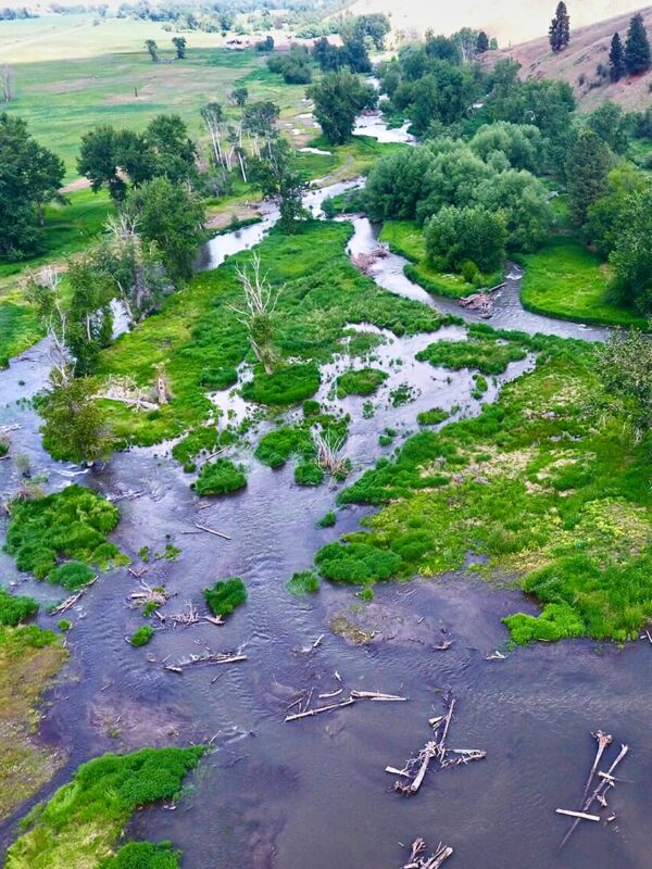
Just downstream from where you cross the Wallowa River, a section of the river’s floodplain was transformed into a thriving ecosystem in the summer of 2022 via a collaborative project between the Wilson-Haun family and Trout Unlimited.
Through intensive efforts, crews dug side channels, placed 500 logs, built 50+ beaver dam analogs, and planted thousands of native trees and plants. This work restored the river’s natural flow, slowing water, replenishing groundwater, and creating essential habitats for salmon, steelhead, lamprey, and other wildlife.
The project’s impact is profound (watch this video). The reconnected floodplain now supports spawning Chinook salmon, increased bird populations, amphibians, dragonflies, and even mammals like bobcats and bears. Game cameras have even recorded a beaver, signaling nature’s return to self-sustaining cycles. Listen to our podcast on the importance of beavers with Maureen Thompson, the Manager of the Beaver Works program at Think Wild.
Old Homestead / ~ Mile 8
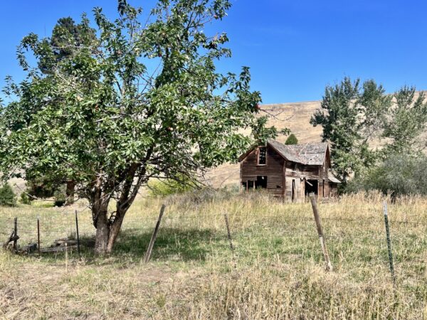
Along the route you will see some mature, gnarly, weathered apple trees. In later summer they are populated with smallish red apples. These trees are usually indicative of homesteads from the late 1800s early 1900s.
Wallowa Mountains / ~ Mile 12
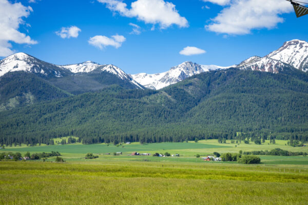
The Wallowa Mountains, often referred to as the “Alps of Oregon,” have the most complicated and longest geological history of any range in Oregon. A unique combination of granite and limestone, so vastly different than that of the Central Oregon Cascades.
Learn how to “untangle what you see” in this podcast with geologist Dr. Kim Ely.
M. Crow General Store / @Finish
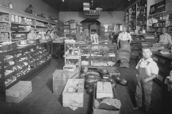
Serving the Wallowa Valley since 1906, the M. Crow General Store was established as a hub for rural commerce. In 2013, it was revived by artist and designer Tyler Hays, who transformed it into a blend of local tradition and modern craftsmanship. It sells locally sourced products, handmade crafts, and Hays’ own designs, ranging from ceramics to custom furniture. Local folklore has it that a gold miner once used the store as a secret drop-off point for nuggets smuggled out of the nearby Wallowa Mountains.
Credits & Acknowledgements
This ride guide is funded in part by a grant from Travel Oregon.

When We Like to Ride This
We like to ride this route in late spring/early summer, when the hillsides are green and the mountains still have snow on their peaks. Early fall is also a fantastic time to catch the Larch and Aspen trees changing color.
Terrain & Riding
This route flows through rich farmland and is on the edge of the Zumwalt Prairie. As one of the the largest breeding ground for hawks in North America, you’re sure to see a wide variety of them soaring overhead. During the summer months, you may be gifted with colorful visions of flowers.
Riding this route in a clockwise direction gives you a nice, slow climb up into the prairie (note, the elevation profile looks deceptively harder than the climb is), with a short, fun, rolling descent coming back into Lostine. Expect mostly rural gravel farm roads.
The Start
Downtown Lostine, M. Crow & Co. can supply snacks and drinks for your day.
Route Notes
The roads you will be riding are working farm and ranch roads. Make sure to give way to those who are working hard to put food on your table! That may mean “skinnying-up” single-file or even stopping to let a piece of machinery by. To learn more about visiting and riding in rural farming and ranch country give a listen to our podcast “Tractors, Bulls and Lycra“.
When riding gravel, it can be noisy and difficult to hear vehicles behind you, especially in a rural setting like this. Thus, we recommend a rear-looking radar device like a Garmin Varia. Using your bike computer, it helps you see traffic behind you.
This route ride well in both directions. As is, the climb is more sustained and the downhill is more rolling. If you reverse direction, the climb is broken up into shorter segments, but you have a longer sustained downhill.
Route Options
Longer Option
This route can be combined with the Building Bridges route out of Wallowa for a double-the-fun kind of day.
Shorter Option
Or, take the Parsnip Creek Road cut off at the old Homestead for a shorter route. 13.2 miles with 700 feet of gain.
Love Where You Ride! Learn More
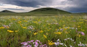 This ride tours a small portion of the Zumwalt Prairie , one of North America’s largest and most ecologically significant native bunchgrass prairies. Covering over 330,000 acres (515 square miles), this stunning landscape is a biodiversity hotspot, home to more than 200 plant species, including rare and endemic (a species found naturally here and nowhere else in the world) varieties.
The Nature Conservancy manages the 33,000-acre Zumwalt Prairie Preserve, about one-tenth of this vast prairie, to protect its biodiversity and ensure its sustainable use. Collaborating with local landowners, TNC balances conservation with economic viability by incorporating managed livestock grazing across half the preserve. Efforts to combat invasive species like Medusahead Rye and sulfur cinquefoil, along with prescribed fire and habitat protection, are key to enhancing plant health and supporting iconic wildlife, including grassland songbirds and raptors.
Videos
Covenant of the Salmon People (Trailer)
The film explores the intertwined fate of the Nimiipuu (Nez Perce), salmon, and the landscape from which both evolved.
Wilson-Haun Wallowa River Project
Learn about this collaborative project between the Wilson-Haun family and Trout Unlimited to restore a section of the Wallowa river near Lostine, Oregon. Their work restored the river’s natural flow, slowing water, replenishing groundwater, and creating essential habitats for salmon, [...]
The M Crow General Store
In this 6-minute video, learn about the M Crow General Store located in Lostine, Oregon. Originally established as a cornerstone for rural commerce in 1906, it was revived by artist and designer Tyler Hays in 2013, who transformed it into a blend of local tradition and modern craftsmanship.
Podcasts
Untangling the Geological History of the Wallowa Mountains
The Wallowa Mountains in NE Oregon have the most complicated and longest geological history of any range in Oregon. In this podcast, we talk with Dr. Kim Ely, a geologist, about this unique and beautiful area. Learn how to “untangle what you see” when riding in the Wallowas!
Tractors, Bulls and Lycra
In this podcast, we talk with Daarla K who is a rancher and farmer in northeast Oregon. She and her husband operate a 1000-acre farm that has been in his family since 1886. Learn how to safely pass by big tractors and combines, how to get through a cattle drive, and what aggressive behavior [...]
Be Informed!

Keep it Local! Learn More
Related Guidebooks
-

All Access Gravel Guide Eastern Oregon (Collector’s Edition!)
$12.50Now shipping! A 64-page pocket-sized gravel guide. Featuring gravel routes, art, culture and local history. A one of a kind…Add to cart -

All Access Gravel Guide Western Oregon (Collector’s Edition!)
$12.50Now shipping! A 64-page pocket-sized gravel guide. Featuring gravel routes, art, culture and local history. A one of a kind…Add to cart
Ridden and Reviewed by:


Have you ridden this route? Got a question? Join the discussion!