Lookingglass
Road closed November – April. See Ride Details tab for more info.


Caution! We do not provide turn-by-turn directions in our GPX files. Those are auto-generated by your bike computer and are usually less than 70% accurate. Learn more.
For help loading a GPX file onto your bike computer, go here.
DownloadHighlights & Remarkable Spots
Eagle Cap Excursion Train / ~ Start
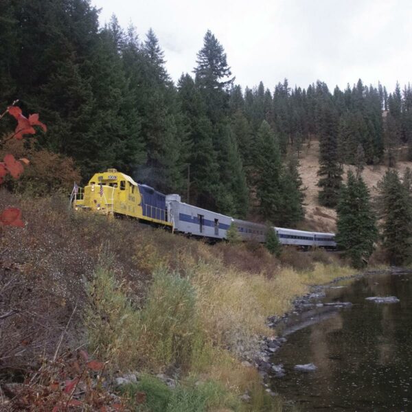
The Union Pacific Railroad (UP) arrived in Union County in 1884, establishing a main line connecting Salt Lake City, Utah, to Portland, Oregon via La Grande. In 1890, the Oregon Railway and Navigation Company constructed a branch line from La Grande to Elgin, eventually extending it further north and east to Wallowa, Enterprise, and Joseph. Abandoned in 1997 with the closure of the mill in Joseph, the county governments of Union and Wallowa counties joined forces to preserve the historic line and now operate tourist excursions along portions of the tracks. We recommend taking a trip on the train! [Wikipedia]
Grande Ronde River / ~ mile 15
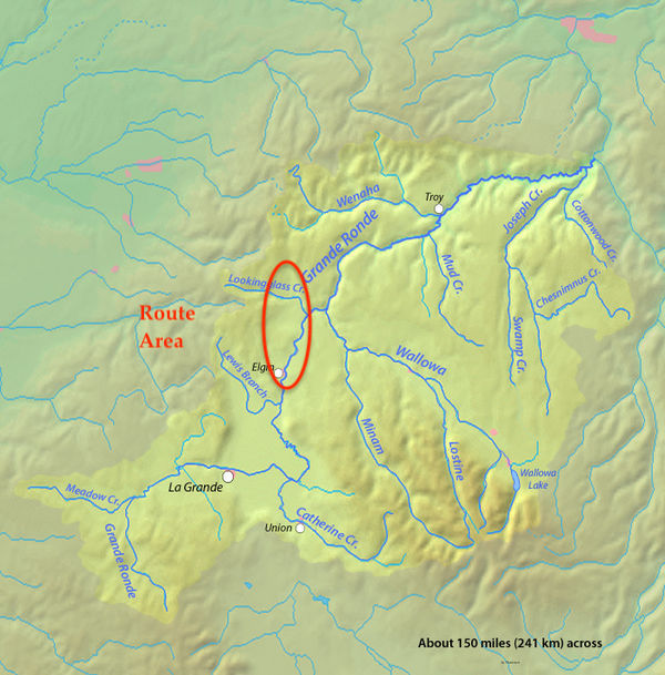
The Grande Ronde River was given its name sometime before 1821 by French Canadian voyageurs working for the Montreal-based fur trading North West Company. Grande Ronde is a French name meaning “great round”.
The River drains an area southeast of the Blue Mountains and northwest of the Wallowa Mountains, on the Columbia Plateau. It flows through the agricultural Grande Ronde Valley in its middle course and through a series of scenic canyons in its lower course, where it is designated Wild & Scenic. The Wild & Scenic designation begins 3-miles northwest of the route (measured from mile mark 16) at the confluence with the Wallowa River.
Click on image to expand.
Palmer Junction / ~ mile 15.5
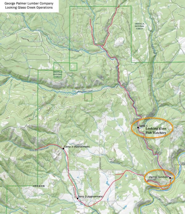
The turn towards Lookingglass Fish Hatchery, away from the Grand Ronde River marks Palmer Junction.
Over a century ago (circa 1911), this area was a thriving logging operation. It is here, where the company’s logging roads linked up the Elgin branch of the Oregon-Washington Railroad & Navigation Company. Roads and lines extended deep into the woods, boasting a 20-mile main line with numerous branches. The sheer scale of operations was evident in the equipment, including a 70-ton Shay locomotive, a 45-ton Shay locomotive, two 4-line Clyde steam skidders, two McGiffert steam loaders, four donkey engines, machine and blacksmith shops, a pumping station, water tank cars for machine use and firefighting, a team of thirty horses, and a fleet of fifty 41-foot steel log cars, complete with stakes and Eau Claire safety trip pockets. [Train Web]
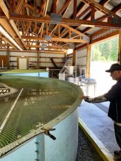
Lookingglass Fish Hatchery / ~ mile 17.5
At ~ mile 15.5 there is a short 3- mile paved dogleg out to the Lookingglass Fish Hatchery along Lookingglass Creek. Go!
The construction of Lookingglass Hatchery in 1982 marked an important milestone within the Lower Snake River Compensation Program (LSRCP), a program aimed at addressing the loss of spring Chinook and summer steelhead populations that resulted from the construction of four federal dams on the lower Snake River. [ODFW].
This project is not without controversy. Hatcheries are often cited as a contributing factor to the demise of wild salmon. Co-managed by the Oregon Department of Fish and Wildlife and the Nez Perce Tribe, Lookingglass Hatchery employs innovative, but experimental methods like supplementation to restore wild fish populations in order to minimize the effects of hatcheries on endangered wild salmon, while also supporting traditional ways of life for the tribe. To learn more, read this Fish and Wildlife Services article on native salmon reintroduction processes.
Joseph Branch Rail Trail / ~ miles 20 to 20.7
The Joseph Branch Trail Rail Consortium is developing a non-motorized trail alongside the existing railroad tracks of the Eagle Cap Excursion Train within the publicly-owned Wallowa-Union Railroad Authority corridor. Starting in Elgin, the trail winds through the Grande Ronde and Wallowa river valleys, terminating 63 miles later in Joseph. Along the way, the trail connects the small towns of Minam, Wallowa, Lostine, and Enterprise.
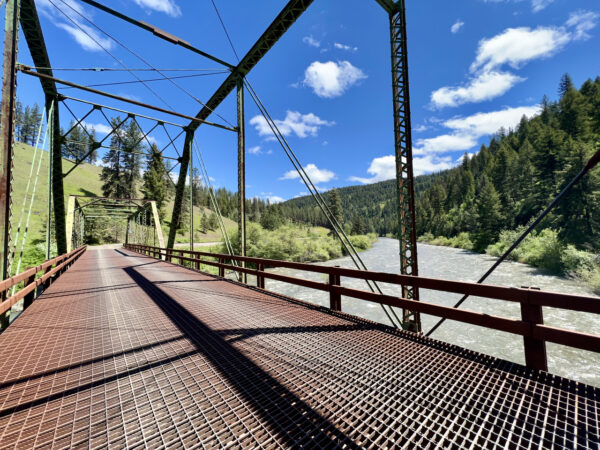
At mile 20.5 when you cross the Grande Ronde river on a metal deck bridge, you get a great view of the tracks and proposed trail.
Highland & Elgin Historic Cemeteries / ~ mile 33 & 40
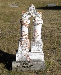
Did you know that the Oregon Historic Cemeteries Program defines an historic cemetery as one with a gravestone that dates back 75 years? Well, at the Highland Cemetery (mile 34) you will find gravestones dating back to the 1880’s and at the Elgin gravestones dating back to the 1870s. Both are a beautiful detour (and walk) and worth your time. [Oregon.gov]
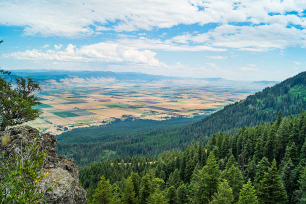
Wallowa Mountain Viewpoints / ~ Miles 27 and 36
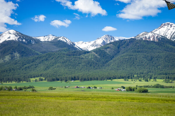
The Wallowa Mountains have the most complicated and longest geological history of any mountain range in Oregon. This range is described by words like batholith, magma, metamorphism, and granodioritic rocks. If this sounds confusing, give a listen to our podcast with geologist Dr. Kim Ely who untangles these complexities into something understandable and fascinating!
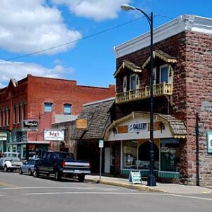
Elgin Opera House / ~ mile 41
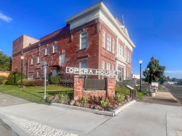
This historic landmark, near the very end of the ride, once served as both an Opera House and City Hall. After years of disrepair, it has been restored to its former glory, reminiscent of its grand inauguration on July 4, 1912. The superb acoustics replicate the ambiance of a first-class European opera house despite its smaller size. Today, the Elgin Opera House stands as a vibrant cultural center, hosting diverse events like live theater, concerts, art exhibitions, and community gatherings. As a non-profit organization, it’s dedicated to promoting the arts and nurturing local talent, fostering a strong sense of community in Elgin and attracting visitors seeking cultural enrichment. Go visit! [Elgin Opera House]
When We Like to Ride This
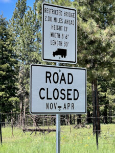 Mid June to early August. This ride is best when the flowers are in full bloom, the creeks running strong, and the mountain peaks still covered in snow. The road at Grande Ronde grade at ~ mile 21 is posted as closed from November through April.
Terrain & Riding
Miles 0 to 13 / Palmer Junction Road / Paved
Undulating hills that traverse farming and ranching territory adorned with vibrant green pastures. Along the way, you’ll breeze past pockets of forests and even treat your eyes to a few breathtaking vistas. Easy riding with light traffic.
Miles 13 to 30 / Rivers & Farms / Mixed
This part of the ride, with two exceptions, unfolds on sturdy dirt roads that are fast and easy riding. The first exception is the out and back to the Lookingglass Fish Hatchery. It is paved (easy!) with a slight uphill grade following Lookingglass creek through a forest of pines to the fish hatchery.
The second exception is the Grande Ronde grade, a 7 to 12% uphill climb of 1.5 miles as you make your way out of the river area. But don’t fret, once you conquer that hill, the ride transforms into a splendid two-lane gravel road heading south over Cricket Flat past open fields with distant vista views. At mile 31 get ready for a drop into Rysdam Canyon past a rustic weathered barn, followed by a jaunt up.
Miles 30 to 34 / The Highlands / Paved
Expect broken, rough pavement that is perfect for a gravel bike. The openness and views continue. At the very end of this sector there is a short segment (0.5 miles) on Highway 82. Ride single file and use caution.
Miles 34 to End / Chunky Descent and Clark Creek / Mostly Gravel
Be prepared to be mesmerized by the springtime spectacle of lush greens, regal purples, and cheerful yellows, all set against the backdrop of distant views showcasing the majestic Wallowa and Blue Mountains. However, this is where you will encounter the most technical sector of the ride.
At mile 36 you drop into a 1-mile descent with an average gradient of 9% on a rugged old chunky farm road that probably sees more cattle than cars. Yes, this is a public road. Near the end of the descent it will feel like your passing through someone’s farm, you’re not! At mile 38 turn right and follow Clark Creek back to Elgin, crossing over the Grande Ronde river again, and passing by the Opera House on your left just before the finish. Clark Creek Road is flat, fast, and scenic.
The Start
Eagle Cap Excursion Train parking lot. When open, there are flush toilets and water. Across the street diagonally there is a full service gas station. In the slide deck, it may appear that there is not parking, but there is! An entire big lot.
Food & Water
- ~ mile 16 / Lookingglass Fish Hatchery
Route Notes
Please ride with respect! Portions of this ride are through rural working ranch and farming country. Please give way to trucks, tractors, and combines. That may mean stopping as a group and letting a large combine pass, or it may be as simple as riding in a tight single-file line when an oncoming truck with trailing is approaching. To help alert you to traffic from behind, we recommend a rear-looking radar detector like a Garmin Varia. Also, give a listen to our podcast with a local rancher who talks about the challenges cyclists create for them and how we can be better visitors.
This could be ridden in either direction. In the CW direction as mapped, the uphill pitches are a bit steeper but the scenic payback is also more grand. In this direction you will also be descending the most technical pitch instead of climbing it.
Love Where You Ride! Learn More
 Prior to white settlement, this region was known as Indian Valley or Fish Trap, favored by Indigenous people for fishing and smoking fish. The landscape changed dramatically with the construction of a bridge over the Grande Ronde River in 1878, which brought a surge of settlers to the region. However, it was the completion of a railroad branch line connecting La Grande to Elgin on October 27, 1890, that marked a turning point in Elgin’s growth.
Before this crucial rail link, the journey from nearby La Grande (today, 20 miles by road) was a made infrequently by pioneers. It was a 120 mile arduous journey by river and trail through dense forests and across hilly terrain. Today the area surrounding Elgin is mostly rolling farmlands with only pockets of forest remaining. [Wikipedia]
Videos
The Ride! Lookingglass
A quick 2-minute video of what to expect on your ride!
Podcasts
Fish Hatcheries: The Insider View
What is a fish hatchery? Why are they important? What fish do they raise? What impacts the survival of the fish? Our guest is Kyle Bratcher who is a District Fish Biologist with the Oregon Department of Fish and Wildlife and he will discuss fish hatcheries with an emphasis on the Wallowa [...]
Untangling the Geological History of the Wallowa Mountains
The Wallowa Mountains in NE Oregon have the most complicated and longest geological history of any range in Oregon. In this podcast, we talk with Dr. Kim Ely, a geologist, about this unique and beautiful area. Learn how to “untangle what you see” when riding in the Wallowas!
Tractors, Bulls and Lycra
In this podcast, we talk with Daarla K who is a rancher and farmer in northeast Oregon. She and her husband operate a 1000-acre farm that has been in his family since 1886. Learn how to safely pass by big tractors and combines, how to get through a cattle drive, and what aggressive behavior [...]
Keep it Local! Learn More
Ridden and Reviewed by:


 Behind every route is scouting, mapping, storytelling, and a whole lot of pedal power.
Have you ridden this route? Got a question? Join the discussion!