In Plain View
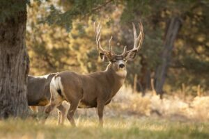
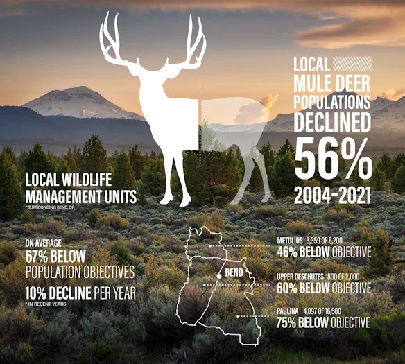
We discourage riding from December 1 to March 15 due to this area being critical mule deer winter habitat.


 - 01")
 - 02")


 - 05")


 - 11")


Caution! We do not provide turn-by-turn directions in our GPX files. Those are auto-generated by your bike computer and are usually less than 70% accurate. Learn more.
For help loading a GPX file onto your bike computer, go here.
DownloadHighlights & Remarkable Spots
Brooks-Scanlon Logging Road / ~ Miles 2 to 13
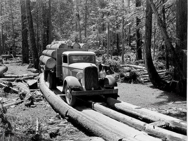
Stretching 27 miles between Bend and Sisters, the Brooks-Scanlon Logging Road traces the route of a once-vital timber corridor through the Deschutes National Forest. Built in the 1910s as a railroad logging line, it later transitioned into a gravel road as trucks replaced trains for hauling logs. The last rail shipment rolled out on December 23, 1956, closing a 40-year era of railroad logging. Along its length, the road hosted portable logging camps—entire communities mounted on rails and moved as forests were cut, leaving only scattered signs of their existence. Between miles 2 and 13, the route delivers one of the most dramatic head-on vistas of North Sister found in Central Oregon.
Skyline Forest / ~ Miles 2 to 13
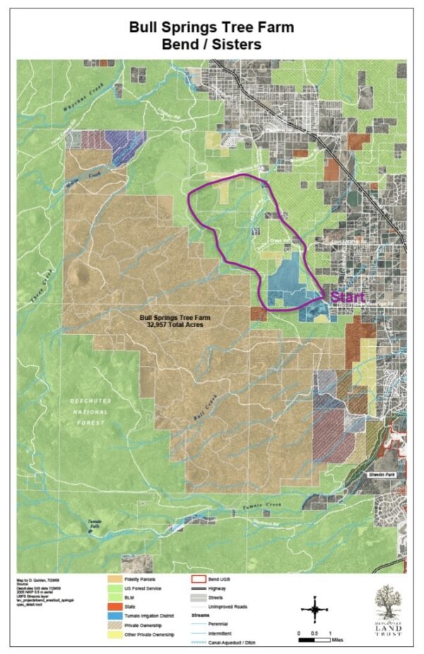
Once known as the Bull Springs Tree Farm, Skyline Forest is a 33,000-acre privately owned timber tract west of Bend and Sisters, once cherished by locals for its mountain/gravel biking, running, and hiking trails. Though never formally public, the land was open for decades and became a recreation hub with panoramic views of the Cascades. That access ended in 2021 when the property was closed, highlighting the uncertainty of its future. Beyond recreation, Skyline is an ecological linchpin: a key winter range for mule deer and elk, a migratory corridor, and a source of clean, cold water for the Deschutes River. Fires in 2010 and 2014 underscored its vulnerability to development and climate stress.
The Deschutes Land Trust and Central Oregon LandWatch are leading efforts to conserve Skyline Forest. You can support by donating, volunteering, joining the Save Skyline Forest campaign, or voicing your support in public forums—helping preserve this ‘backyard forest’ as both wildlife refuge and future recreation space.
Click on the map to the left to compare the In Plain View route with the boundaries of Skyline Forest.
Two Bulls Fire / ~ Mile 3
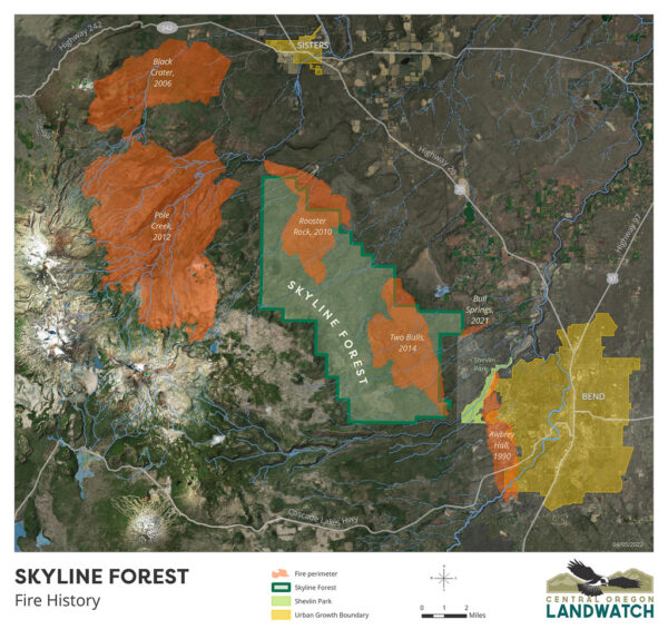
The Two Bulls Fire (June 2024) stood out for its timing. Fuels were a month drier than normal for early June, offering one of the first clear warnings of Central Oregon’s lengthening fire season. The blaze swept through federal and private forest, threatening near by ranches and homes, exposing the risks of the wildland–urban interface. Burn severity was uneven: some ridges were stripped bare, while other areas retained green stands thanks to natural breaks and prior fuel treatments. In the aftermath, salvage logging was weighed for the most damaged tracts, and closures restricted access due to falling snags and unstable slopes. Click on map for expanded view.
Three Sisters Mountains / ~ Mile 15
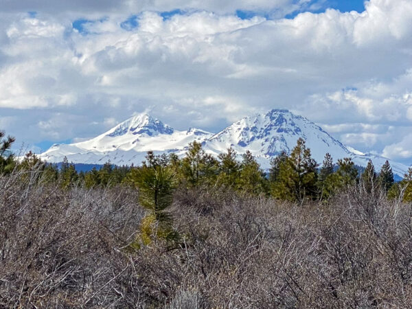
South Sister, Middle Sister, and North Sister are three geologically young volcanoes that make up the backbone of the central Oregon mountain skyline. Ever notice how the Cascade volcanoes from Mount Baker in Washington all the way down to Mount Lassen in California generally fall in a straight line? Oceanic crust on the Juan de Fuca plate is being subducted under the North American plate, slowly sinking toward hotter temperatures where trapped water heats up and rises, melting rock along the way, eventually bursting through the crust to form a volcano. Connecting the dots of these volcanoes essentially outlines the edge of that sinking plate!
Old Growth Juniper / ~ Miles 17 to 22
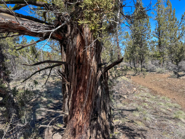
In this sector, if you look closely, you will see some of Central Oregon’s oldest juniper trees, many predating white settlement and reaching 200–400 years in age. Unlike younger stands, their age is revealed not by size but by character: deeply furrowed bark, twisted trunks, gnarled limbs, and draping mats of lichen. True old growth is uncommon—only 3–5% of juniper woodlands qualify. Their rarity reflects changes in the landscape: fire suppression and grazing have enabled dense younger stands to expand into areas where juniper once grew only sparingly. Learn more in this podcast.
Tumalo Canal Project / ~ Mile 20.5
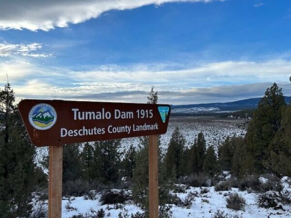
Some call it a “Dam Fiasco.” In the early 1900s, a conman developer from Portland sold arid land to hundreds of settlers with a promise that it would be farmable and irrigated. Then he fled the area. The State of Oregon stepped in to assist, developing the irrigation district by constructing canals and two dams – the Bull Creek dam and the Tumalo Dam, which is the dam right here at mile 20.5 of this route. Unfortunately, an unskilled engineer failed to discover prior to construction that the reservoir floor was highly porous – a fact that became evident when whirlpools formed once the reservoir filled. Concrete gate houses for water flow regulation are still visible here today.
Bull Flat & Peck’s Milkvetch / ~ Mile 22.3

About 10 square miles around Tumalo are home to one-third of the world’s dwindling population of a rare and threatened plant: Peck’s milkvetch (Astragalus peckii). Named for famous Oregon botanist Morton Peck, Peck’s milkvetch is a nitrogen fixer – a plant that can convert nitrogen in the air to usable nitrogen in the soil, which helps feed other plants. The population of Peck’s milkvetch found in Bull Flat here at mile 22.3 has been extensively studied and is most endangered by offroad motorized vehicle use. [Central Oregon Landwatch]
Credits & Acknowledgements
This ride guide was funded in part by a grant from the Deschutes Trails Coalition.
When We Like to Ride This
Fall and spring. And when we are limited on time and need a quick go-to ride. This route will hold snow in the winter, and we discourage use during this time due to the area being a critical mule deer winter habitat. The area is closed from December 1 to March 15 to motor vehicles and may be closed during the summer months due to wildfire risk.
Terrain & Riding
With under 23 miles and less than 900 feet of elevation gain, this Bend Short is a great after-work ride. To create the loop, the Sisemore Road and the old Brooks-Scanlon Logging Road (Forest Road 4606) are linked via unimproved 1.7 and 3 mile connector roads. Ridden clockwise, the gentle grade of the Brooks-Scanlon road provides a solid warmup and saves the smooth gravel surface of Sisemore for the second half. However this direction leaves a challenging one-mile, 5% average grade climb closer to the end (mile 18).
Brooks-Scanlon has attractive low grades but we recommend 45mm tires (or better yet, 50mm tires), as it has some rough sections and there is potential for late-season sand. Sisemore Road, a long-time favorite among cyclists, is a high quality gravel road between Bend and Sisters. The connectors both have unimproved sections and see sandy parts late in the season (although the sand on these sections is the kind that sees improved rideability with from recent rainfall).
This route is not affected by the gate closures near the Verhyden property, though the closures have vastly reduced vehicular traffic on the Brooks-Scanlon Logging Road. As such, the quality of this gravel route appears to be improving year after year.
The Start
Ad-hoc dirt parking lot just south and east of Tumalo Reservoir. At the intersection of Tumalo Reservoir Road (paved) and Sisemore Road (gravel).
Food & Water
- None
Route Options
Shorter option: Snow Creek Shortcut (9.5 miles, 350 feet of gain)
At mile 5.2 turn right onto Snow Creek Road. At mile 7.1 intersect the original route. GPX file download.
Love Where You Ride! Learn More
 Few people realize that just west of this route lies the unprotected Skyline Forest, a vital winter habitat for mule deer and elk. Nearby, Bull Flat is home to a rare plant species known as Peck’s milkvetch. For these reasons, we ask that you tread lightly, stay on designated roads, and take a moment to learn more about these special places through the links above.
Videos
The Ride! In Plain View
A quick 2-minute video of what to expect on your ride!
The Infamous Tumalo Reservoir!
Learn how a broken promise by a developer in the early 1900s led the state to build a reservoir that couldn’t hold water.
Podcasts
Skyline Forest (It’s not public land?)
What! It is not public land? Ben Gordon, Executive Director of Central Oregon Land Watch, joins us to discuss a large area of private land called Skyline Forest and what the future entails for this 33,000 [...]
Controversial Juniper Trees
The juniper tree is an iconic tree across Central and Eastern Oregon and yet, in some places they are being removed. Find out the real scoop about this unique tree from Gena Goodman-Campbell who is the Stewardship Director at ONDA (Oregon Natural Desert Association) where she works to engage [...]
Be Informed!
Keep it Local! Learn More
Outfitters
Related Guidebooks
-

All Access Gravel Guide Eastern Oregon (Collector’s Edition!)
$12.50Now shipping! A 64-page pocket-sized gravel guide. Featuring gravel routes, art, culture and local history. A one of a kind…Add to cart -

All Access Gravel Guide Western Oregon (Collector’s Edition!)
$12.50Now shipping! A 64-page pocket-sized gravel guide. Featuring gravel routes, art, culture and local history. A one of a kind…Add to cart
Ridden and Reviewed by:


 Behind every route is scouting, mapping, storytelling, and a whole lot of pedal power.
Have you ridden this route? Got a question? Join the discussion!