GravelCracker (The Overlander)
 - 1")
 - 2")
 - 3")
 - 4")
 - 5")
 - 6")
 - 7")
 - 8")
 - 9")
 - 10")
 - 11")
 - 12")
 - 13")
 - 14")
 - 15")
 - 16")
 - 17")
 - 18")

 - 20")
 - 21")
 - 22")
 - 23")
 - 24")
 - 25")
 - 26")
 - 27")
 - 28")
 - 29")
 - 30")
 - 31")
Caution! We do not provide turn-by-turn directions in our GPX files. Those are auto-generated by your bike computer and are usually less than 70% accurate. Learn more.
For help loading a GPX file onto your bike computer, go here.
DownloadHighlights & Remarkable Spots
Black Butte / ~ Miles 9 to 17
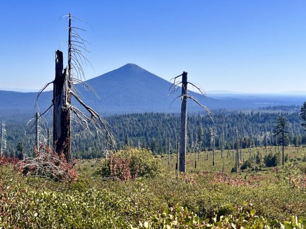
“As you drive toward the flats of Central Oregon toward this symmetrical volcano, you might well wonder why it erupted here. The more famous High Cascades peaks formed along a fault that has been leaking lava for millions of years. But Black Butte grew along a different, parallel crack to the east. This fault also uplifted Green Ridge’s scarp to the north, leaving the Metolius Valley as a long trough. Black Butte began to erupt quite recently, perhaps only 20,000 years ago. It quickly built up a 3,000-foot pile of cinders, one of the tallest such cones in the state. The eruption also buried the Metolius River, creating Black Butte Ranch’s swampy meadows on one side of the mountain and Metolius Springs on the other, where the river now emerges.” [Oregon.com]
Metolius River / ~ Miles 22.5 to 30
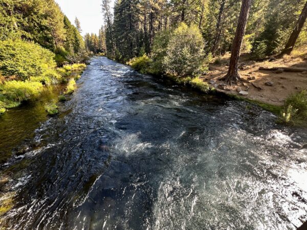
You’ll ride along the spectacular and unique Metolius river for almost 10 miles. “Nationally renowned for its amazingly clear and cold water and fabulous fly fishing, the river basin also provides outstandingly remarkable geology, scenery, botanical, cultural and historic values. As it flows through memorable stands of old growth ponderosa pine it is as cherished by the thousands who visit it annually from across the nation as it is by the Native Americans who share in the traditions and administration of this rare resource.” [National Wild and Scenic Rivers System]
Camp Sherman / ~ Mile 22.5
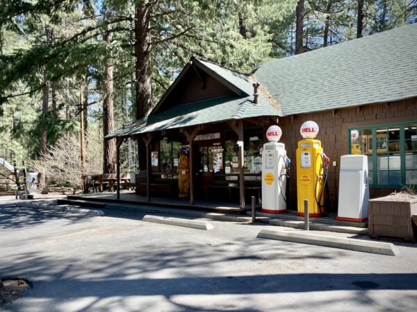
When was the last time you shopped in a general store that’s been operating for over 100 years? Now’s your chance! (Go left a short distance at mile 22.5.) Camp Sherman “came about in the early 1900’s, when wheat farmers from Sherman County sought out the land as a refuge from the intense summers. They found the river refreshing and relaxing. They nailed up a sign – made from a shoe box top – designating the area as Camp Sherman.” [AllBendOregon.com]
Allingham Meadow / ~ Mile 23.4
Use this link as resource info. Summarize.
Wizard Falls Fish Hatchery / ~ Mile 31
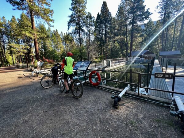
Wizard Falls Hatchery offers a park-like setting, display pond, interpretive signage, and platform for viewing fish in the settling pond. It was constructed in 1947 … “The hatchery is used for incubation and rearing of kokanee salmon and rainbow trout to provide for recreational fishing program objectives, and the incubation and rearing of spring Chinook and summer steelhead as part of a reintroduction program in the upper Deschutes Basin. Brook trout and cutthroat trout fingerlings are reared for the air stocking program on odd years. Kokanee salmon are spawned remotely.” There is a picnic area and restroom as well! [Oregon Department of Fish and Wildlife]
B&B Complex Fires / ~ Miles 32 to 55
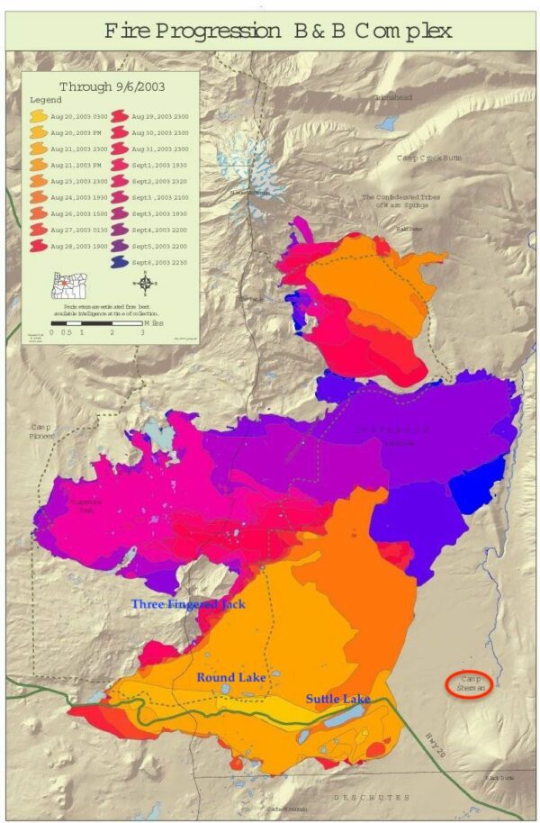
The B&B Complex Fire in 2003 which burned 90,000 acres and cost $38 million to fight, is now widely regarded as the first wake-up call that ushered in the era of larger, hotter, faster, and more frequent forest fires in Oregon. It originally started as two separate fires – the Bear Butte Fire and the Booth Fire – which merged when fueled by 35 mph winds and 90-degree temperatures. The plume of smoke rose 35,000 feet into the sky and was visible as far away as Portland. The fire blanketed Central Oregon with smoke during President George W. Bush’s visit to Redmond who characterized it as a “holocaust.” [Statesman Journal]
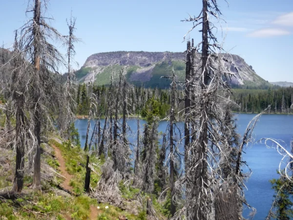
Round Lake / ~ Mile 52.5
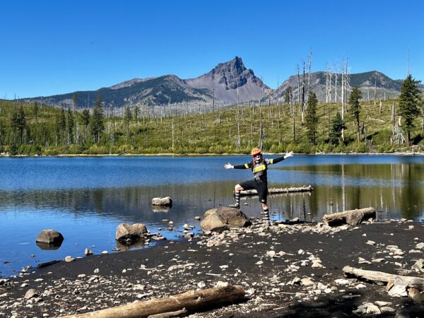
Round Lake is a beautiful, serene lake with camping options and unobstructed views of Three-Fingered Jack and its jagged, craggy peaks. You wouldn’t know it by how it looks today, but Three-Fingered Jack was part of a series of shield volcanoes: “broad volcanoes with gentle slopes and are shaped somewhat like a warrior’s shield lying flat on the Earth.” [NPS.gov] But it wasn’t that simple for Jack. Overlapping cinder cone activity, lava dikes, and volcanic plugs further built up the mountain’s shape and structure before glaciers moved through scraping and sculpting it closer to what you see today. He’s been through a lot but he wears it well don’t you think?
Suttle Lake / ~ Mile 62
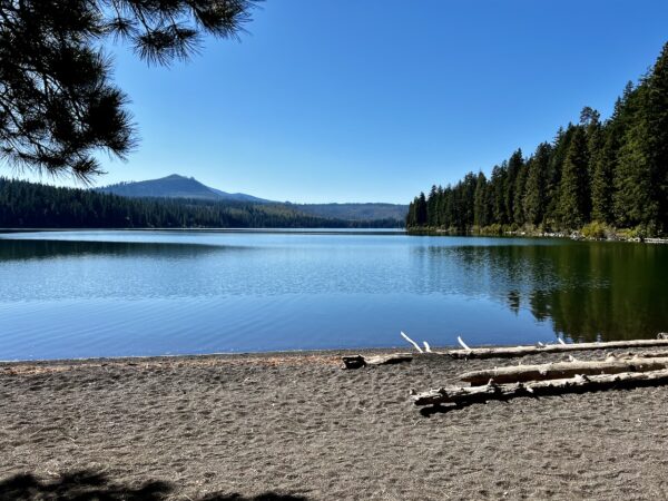
The Suttle Lake Day Use Area would be a great place for a snack or bike-fishing stop or you could grab lunch at the lodge bar. “Bound on all sides by mixed conifer forest, the lake is deep and clear. The west end is best for seeing waterfowl because it’s sheltered from the prevailing wind. Link Creek, which empties into Suttle Lake, is shallow and clear enough to view spawning fish. Yellow, orange, or red hues from vine maple proclaim the arrival of autumn in September or October. The lake was formed from a terminal moraine, which was deposited by glacial ice about 25,000 years ago … The lake covers an area of 253 acres. The average depth of the lake is 44 feet with a maximum depth of 75 feet. The lake has an excellent population of naturally reproducing kokanee, plus brown trout, whitefish, and crayfish.” [Deschutes National Forest]
Black Butte Ranch / ~ Mile 64
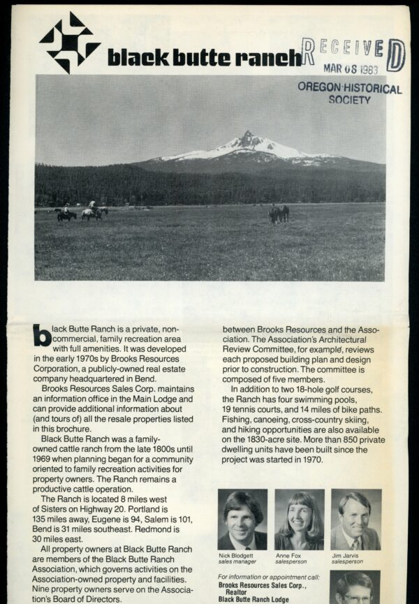
The land now occupied by the Black Butte Ranch resort was an operating horse and cattle ranch as early as the 1880s. Once a thriving lumber town, Sisters fell into decline with the closure of the lumber mills in the 1960s. Brooks Resources, having purchased the ranch land in 1969, saw an opportunity to create a resort that would spur Sisters’ local economy through tourism. When they “began developing the Ranch, they offered merchants in Sisters $5,000 and free architectural help to create a ‘theme’ look to the town. The Sisters planning commission adopted an 1880s theme, which improved the town’s attractiveness and returned it to its original roots.” The homeowner’s association now owns and manages the property which includes golf courses, tennis courts, swimming pools, restaurants, and a general store. [Black Butte Ranch]
GW Fire of 2007 / ~ Mile 65.5 to 67
Over Labor Day weekend of 2007, 1,000 residents of Black Butte Ranch were evacuated and their homes threatened by a wildfire that ultimately was extinguished safely. “The GW Fire was stopped only a 1/2 mile west of Black Butte Ranch, thanks, in part, to a fuels treatment designed to restore a ponderosa pine stand and reduce the threat of wildfire in the wildland urban interface. Over the course of several years, fuels specialists from the Deschutes National Forest thinned and burned the area just west of Black Butte Ranch, creating a healthier stand of trees and a more open site that was less capable of supporting a crown fire.” [US Forest Service]
Hayrick Butte
Hayrick Butte, a somewhat rare type of formation called a tuya. A tuya is the result of a volcano erupting under a massive ice sheet and melting its way through to the very top where lava then pools at the ice surface. Check out our podcast about Hayrick Butte with geologist Dr. Kim Ely.
Hayrick Butte likely formed when lava erupted underneath an overlying glacier or ice sheet, producing the flat top with near-vertical walls along the ice-contact margin as the lava cooled and hardened. Hayrick Butte has a nearly flat plateau about 0.5 miles (0.80 km) across and steep walls rising about 700 feet (0.21 km) above its surroundings. A cartographer accidentally switched the names for nearby Hoodoo Butte and Hayrick Butte; the word “hoodoo” usually refers to rock piles and pinnacles like those observed at Hayrick Butte.
When We Like to Ride This
This route rides best in the spring / early summer or late fall when the “washboard” is to a minimum, the peaks are snow-capped, and the colors are in bright. If possible, do the ride midweek and not on a holiday weekend.
Terrain & Riding
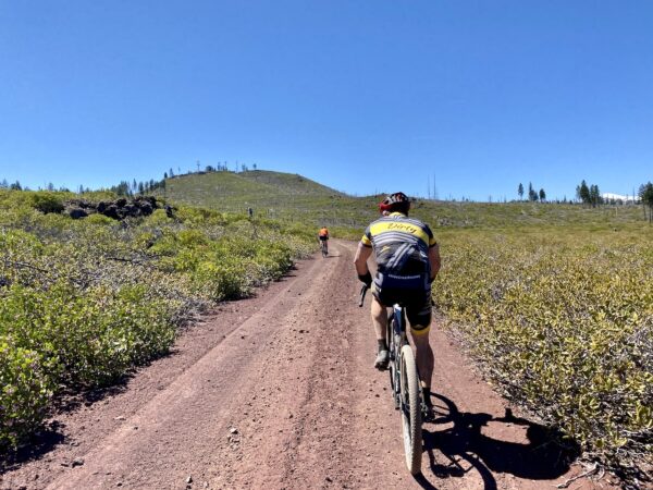
The ride begins with an ~ 8-mile paved section with big views of the Three Sisters mountains, then the real riding begins. The first off-pavement section is a wooded traverse of the shoulder of Black Butte. This section will have a bit of “old school” feel to it.
Next up, a quick stop at the Head of the Metolius followed by a singletrack section meandering next to the Metolius River. Ride along the river down to the Wizard Falls Fish Hatchery and climb and descend through the 2003 B&B Complex fire area.
Relax for a moment on the pavement, then begin the climb up to Round Lake. The climb feels steeper and longer than it actually is. Stop at the lake to cool off and take in the great views.
Now, begin the moderately demanding descent. At about two-thirds of the way down, take a sharp right following the cinder road to within 50 to 100 yards from the highway. Look for a trail to left, take it. Then, in about 50 yards come to a 3-way intersection, take the right leg towards the highway / Suttle Lake. This is the Lake Creek Tail. It will cross underneath the highway and then lead you to the beginning of the 3-mile singletrack traverse around Suttle Lake.
Refill water at the Suttle Lake Lodge. Next up, another singletrack section that leads you to the west edge of Black Butte Ranch. Take a breath on the pavement, then begin the last gravel section. After topping out on Gravel Cracker Hill it is all downhill from here (it’s a short popper hill with big views).
The Start
Village Green City park in downtown Sisters. Flush toilets, showers, and water.
Food & Water
- ~ Mile 26: Camp Sherman (food & water)
- ~ Mile 31: Wizard Falls Fish Hatchery (water)
- ~ Mile 62: Suttle Lake Lodge (water)
- ~ Mile 80: Cold Spring Campground (water)
Route Notes
As of September 2023, we have made a major revision to this route. In general, we added more single-track riding and deleted the segment around Suttle Lake (the trail on the north side of the lake needs a lot of work). This route, The Overlander, is based on the the original GravelCracker 85 route. Things have changed and the distance is no longer 85 miles, thus the name change.
At mile X you may see this sign. It looks ominous. The road is public! (We have verified this with the Forest Service.) For a short distance the lands to the left and the right of the road are private.
Route Options
If you are adventuresome, you may still want to include the loop around Suttle Lake. This adds about 3 miles. We recommend doing it in a counter-clockwise direction. Pick up the single-track trail at the picnic area on the east side of the lake, between the lodge and the highway. The north side of the trail has become more technical over time. Expect some washout and larger jump overs of roots.
Love Where You Ride! Learn More
 Trails don’t come for free! It takes time, talent, and money to develop great trails. The super fun dropbar single-track trails on this route were developed and are maintained by the Sisters Trail Alliance. If you like what they have done, please consider making a contribution to their campaign or your local trails organization so that they can continue the great work!
Videos
Trail Etiquette (Horses, Hikers & Bikers)
Whether you like to hike, bike, or ride a horse, we all want to enjoy our trails safely. Learn how to share the trail respectfully!
Keep it Local! Learn More

Ridden and Reviewed by:


 Behind every route is scouting, mapping, storytelling, and a whole lot of pedal power.
Have you ridden this route? Got a question? Join the discussion!