Ashes to Glory


Caution! We do not provide turn-by-turn directions in our GPX files. Those are auto-generated by your bike computer and are usually less than 70% accurate. Learn more.
For help loading a GPX file onto your bike computer, go here.
DownloadCredits & Acknowledgements
This route was first proposed and put together by AndrewL, the event promoter for the Ashes to Glory race. Great idea!
When We Like to Ride This
In the spring when the creeks flow full and the flowers are in bloom. (Truly our favorite time.) Or on a cool, sunny fall day when the trees are changing colors. Or, on a winter day, when the ground is frozen (yes, frozen, not just cold). It is best to avoid this route when wet or muddy because the mud can really stick to your bike.
The Start
Juniper Hills park. Flush toilets.
Food & Water
- ~ Mile 35 / Ashwood. At the old post office, there is (as of June 2021) an honor system “store” with snacks, drinks, and ice cream (bring your small bills).
Route Notes
This route has been impacted by the Cram Fire of 2025. It ignited on July 13, near Highway 97 east of Madras, and become the largest active wildfire in the United States, burning over 95,000 acres as of July 21. The fire destroyed dozens of homes and outbuildings. For the latest information see Central Oregon Fire and the Cram Fire Facebook page.
Love Were You Ride!
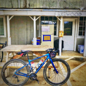 The people of Ashwood have put up a self-help store at the old post office. It has water, Gatorade, chips, and ice cream. They have also created a picnic and tenting spot with pit toilets. We encourage you to thank them for their support by dropping into the donation box a bit more than what you take. A heartfelt note of thanks is always nice too!
Videos
Columbia River Plateau Basalt
Massive lava flows covered much of the inland Northwest 17 million years ago. The basalt surged to the surface through fissures - like cracks in the bottom of a row boat. The stack of basalt layers is more than 2 miles thick at some locations. Learn a bit more about this geological feature in [...]
Podcasts
All About Basalt with the Rock Doctor
You will find these rocky columnar cliffs in Eastern and Central Oregon, but what exactly happened to form these unique structures? In this podcast, we talk with our resident rock doctor, Dr. Kim Ely.

 Behind every route is scouting, mapping, storytelling, and a whole lot of pedal power.
Have you ridden this route? Got a question? Join the discussion!