Journey to Jurassic


Caution! We do not provide turn-by-turn directions in our GPX files. Those are auto-generated by your bike computer and are usually less than 70% accurate. Learn more.
For help loading a GPX file onto your bike computer, go here.
DownloadHighlights & Remarkable Spots
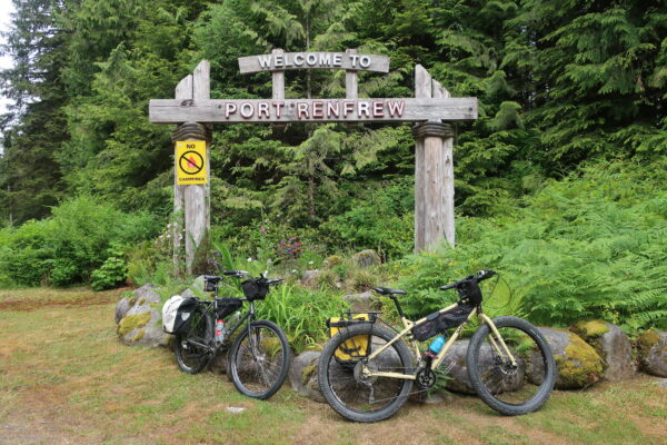
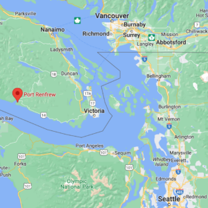
Port Renfrew / Beginning and End of Ride
The town of Port Renfrew, native land of the Pachedaaht First Nations, was once a thriving logging community. When conservation efforts began focusing attention on the incredible old-growth forests in the area, the town’s focus shifted from logging to ecotourism. Port Renfrew has attracted an increasing number of tourists who wish to see the largest and oldest trees in what is now known as the “Tall Tree Capital of Canada.” With all the changes, the community has realized that revenue from tourism surpasses that from logging. [Ancient Forest Alliance]
Olympic Mountains Viewpoint / ~ mile 7
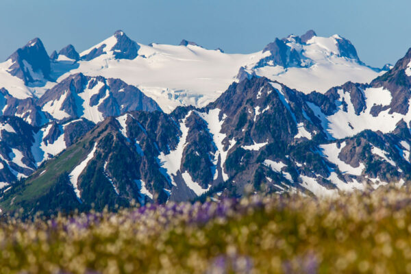
Washington state boasts volcanic mountains from the north to the south like Mt Rainier, Mt Adams, and Mt St Helens. However, the Olympic Mountains are not volcanic mountains, but there is some geology that makes it seem as if they were. Years ago, underwater volcanoes erupted, gushing lava that cooled into basalt, a distinctly volcanic rock, on the ocean floor. Ocean sediment and this volcanic rock built up atop the tectonic plate below, blanketing the ocean depths. About 34 million years ago, just off of what was the former coastline, two massive tectonic plates, the North American Plate and the Juan de Fuca Plate, were sent into a collision that would literally shape the Olympic mountains. The Juan de Fuca plate is currently being forced under the larger North American plate, causing uprising of the landscape, crumpling of rocks, and endless jagged peaks. Learn much, much more with the [National Park Service].
Jurassic Grove / ~ Mile 13.5
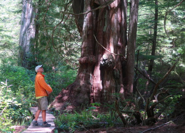
In late 2018, the Ancient Forest Alliance identified the grove as “an exceptional stand of unprotected, monumental old-growth trees a 90-minute drive west of Victoria.” The Jurassic Grove is located to the south east of Port Renfrew along the the Juan de Fuca Provincial Park. [Ancient Forest Alliance]
When We Like to Ride This
Though the route is rideable year-round, the winter months are cold and wet. The riding is best June through September when the temps are warmer and the skies are drier.
Terrain & Riding
This route is entirely on the Juan de Fuca Highway (Hwy 14), which is all paved. Though the road does not have heavy traffic, you will certainly encounter automobiles and possibly logging traffic, too. The road is narrow and winding with no shoulder heading out of Port Renfrew, but a shoulder will appear (and occasionally disappear) as you get closer to Jurassic Grove.
The main destination of this route is Jurassic Grove, which is located at the turnaround point. About a mile before the trailhead to Jurassic Grove is an optional unnamed grove (~ mile 13.0). The trail is located approximately one-third of the way down the concrete barrier, approximately 25 ft before the telephone pole. The opening to the trail is obscured by bushes. Exploration of this grove is not for the faint of heart as the trail is difficult to follow. Consider tracking closely to the green trail on the map to head towards the big trees, and then continue on using your best judgment. Allow at least 45 minutes to explore the unnamed grove.
Note that the trailhead to the Jurassic Grove is not marked. Look for an opening in the trees, and an obvious, formal trail just beyond the opening. Just inside the opening in the trees, there is a nice, open area where you can lock your bikes to smaller trees. Once you lock up your bike, start walking on the trail, which leads down to the water at Chin Beach. To get to Jurassic Grove, follow the trail at the far left once you see the first big cedar. You will know you have reached Jurassic Grove when you see the boardwalk. Allow at least 1 hour to explore Jurassic Grove and to walk a part of the Chin Trail towards the beach and back.
The Start
The route begins at the Pacheedaht Gas Bar in Port Renfrew. There is a gas station here, as well as a small convenience store. The Visitors Center, which offers information and WiFi, is located in the back left corner of the property. Ask for permission to park here. You may or may not be granted permission.
If you are staying overnight in Port Renfrew, it would be best to park at your lodge or campground and cycle to the Pacheedaht Gas Bar to begin the route.
Day-use parking is available for $15/day at the Pacheedaht Campground. The campground has two day-use lots – one at the entrance to the campground at the northwest corner of the San Juan Bridge and the other just across from the West Coast Trail Registration office. Pay for the parking at the Pacheedaht Campground Office (305 Pachidah Rd in Port Renfrew). Be aware that the office is not staffed full-time, so you may need to wait an hour or so for staff to appear.
Food & Water
- Start & End / Community of Port Renfrew
Route Notes
The climate in southwest Vancouver Island is temperate. Temps can be warm or cold and the skies can be dry or wet…all in the course of a single day! Be sure to pack appropriate layers and raingear. Wear visible colors, especially since you are riding a route with logging traffic.
The light on the route can vary from sunny to shady and all hues of filigreed light in-between. Wear bright colors and consider using bike lights. Keep your eyes open for potholes or other obstacles that may be obstructed by the shade.
Do not judge your time to ride this route based on the mileage and elevation alone. Allow plenty of time to get off your bike to walk around and meet the trees. Make sure to wear comfortable shoes for walking. Be mindful not to tread on the roots of the big trees. Also, keep in mind that it is very easy to get turned around in the forests. Consider tracking your location with your phone or device as you walk the forests so that you can find your way back to your bike.
Black bears live in the forests of Vancouver Island. Though the bears in the southern part of the island tend to be skittish, be bear-wise and consider carrying bear deterrent with you.
Most of the bridges in the area are narrow and can only accommodate one-way traffic. Slow your speed as you approach all bridges, and be mindful of the signs indicating to yield to oncoming traffic. As you cross the bridges, consider peeking over the sides, as some bridges cross creeks with dramatic canyon walls, waterfalls, and/or pools. Perhaps one of these creeks will entice you for a mid-ride swim!
You will not be able to ride your bicycle along any of the trails to see the big trees or groves. You may be able to find a place to lock up your bicycle, but keep in mind that many of the trees in the forests are too girthy for a bike lock. Consider stashing your bicycle in a not-so-obvious place near the trailhead.
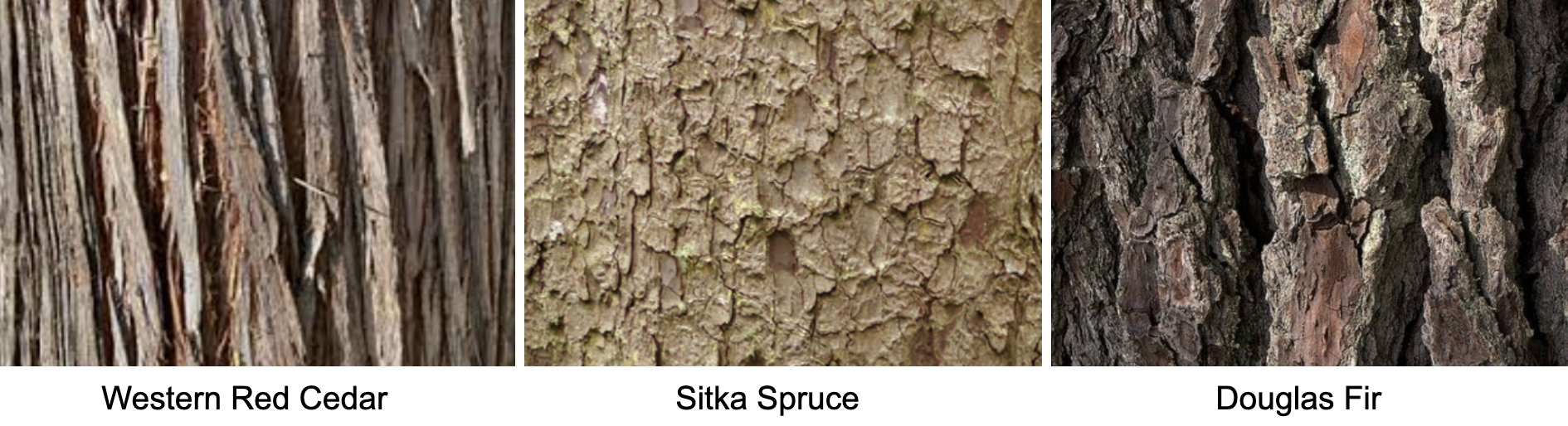
You’ll get far more bang for your buck on this tour if you learn to identify Western Red Cedars, Sitka Spruces, and Douglas Firs. We recommend you learn to recognize the barks of these trees, as the needles for these giants will be too hard to see. Cedar bark is linear, spruce bark is scaled, and fir bark is cracked.
We’d like to get a more accurate read on the elevation gain for this route. After you’ve ridden this route, leave us a note in the Comments telling us the gain according to your device.
Dirty Freehub's READ & RIDE Program
 It’s one thing to see massive trees in an old-growth forest as you cycle along beautiful gravel roads. It’s another thing to understand the significance, history, and impact of the trees. This route is part of Dirty Freehub’s READ & RIDE program. READ to learn about the old-growth trees on southwest Vancouver Island. Then RIDE to meet the trees in-person. Click here to learn more.
Videos
Giant Tree Hunters
Big tree photographer and wilderness explorer, TJ Watt, searches to find the biggest tree in Canada in the rainforests on southern Vancouver Island. In Port Renfrew, he's joined by two big tree climbers in an attempt to break a world record.
Podcasts
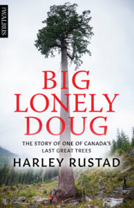
Big Lonely Doug
Ever visited a location from your favorite book? Cool, right? Dirty Freehub’s new READ & RIDE allows you to do just that! READ & RIDE matches 5-star gravel routes with books to create a memorable journey. Read to learn, then ride to bring the pages to life! No worries if books [...]
Tree Conservation Through Photography with TJ Watt
Meet TJ Watt, Big Tree Hunter, co-founder of the Ancient Forest Alliance and an award-winning nature and conservation photographer from British Columbia whose images have helped bolster campaigns to secure the protection of important environmental areas.
In this episode, TJ explains [...]
Saving Old Growth Trees with Ken Wu
Ken Wu, former Executive Director and Co-Founder of the Ancient Forest Alliance, has spent years protecting ancient forests in British Columbia. A major player in protecting Big Lonely Doug, Ken tells how he named the iconic Doug Fir. He also talks about how the indigenous people of Canada [...]
Big Lonely Doug with Author Harley Rustad
Meet Harley Rustad, author of Big Lonely Doug: The Story of One of Canada’s Last Great Trees. In this episode, Dirty Freehub’s Sarah Burch interviews Harley about his book for the READ & RIDE program. Learn what inspired Harley to write Big Lonely Doug, how his book has [...]
Keep it Local! Learn More
Ridden and Reviewed by:

 Behind every route is scouting, mapping, storytelling, and a whole lot of pedal power.
Have you ridden this route? Got a question? Join the discussion!