Patagonia 80


Caution! We do not provide turn-by-turn directions in our GPX files. Those are auto-generated by your bike computer and are usually less than 70% accurate. Learn more.
For help loading a GPX file onto your bike computer, go here.
DownloadWhen We Like to Ride This
Fall to spring when the skies are clear and the temps are moderate. We would avoid this route in summer as it is very exposed to the sun. Wind could also make this route brutal. And … if it has recently rained, give it several days to let the roads dry, they are of a clay base and can turn into super sticky mud.
Terrain & Riding
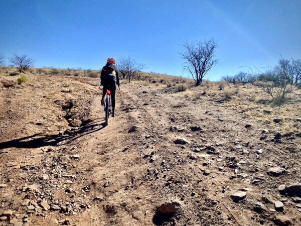
From creek crossings to long downs and ups; from shifting ecology to frequent winds; from mining trucks and Border patrol to pronghorns and wild turkeys, this ride is sure to keep you on your toes. While there are sections of pavement on this route, we suggest savoring those moments as they are balanced by some fairly rough roads in other sections. Particularly be aware of the section after you leave Highway 83 at mile 36. Once you turn left before Parker Canyon Lake, expect washboards, loose rocks and/or embedded rocks as you climb to the high point of the ride. The descents are enough to knock water bottles from cages.
This will be followed by a dozen miles with a variety of short climbs and descents, with relatively smoother roads on the level portions. Don’t expect to bomb down the hills as you’ll still find healthy portions of chunk on the ups and downs.
And! What would riding in Arizona be without some sand? Expect some sand pits on the west side of Lochiel. Pick a line and stick with it. Push through two more big climbs, some deeper creek crossings, and then enjoy some fine rollers before descending on pavement back to Patagonia.
The Start
Patagonia Town Park. Street side parking on McKeown Avenue. Flush toilets. Water.
Food & Water
- ~ Mile 35.5: Water and food can be found at the Parker Canyon Lake and Marina general store (seasonal). At the intersection of Highway 83 (paved) and Montezuma Canyon road (gravel) continue straight towards the lake instead of going left. This will add ~ 1 mile.
Route Notes
Riding in the desert southwest is often very different from riding in Colorado or Oregon, with terrain that is noticeably more rugged and challenging. For tips and advice, check out our Resource Page: Riding in the Desert Southwest.
Specific to this route, most of the gravel roads in the San Rafael Valley are hard-packed and fast. However, over the last 5 to 7 years the roads (as most in southern Arizona) have become more rugged due to increased vehicular usage. Thus, our tire recommendations have changed to 50 mm+.
We recommend riding the route in the direction shown on the map so that you’ll descend through the sandy section near Lochiel instead of climbing it.
There are a number of turns along the route, if you miss a turn you may end up going a long way before finding pavement.
The area is actively patrolled by Border Patrol. As a general practice, when we encounter Border Patrol for the first time each day, we stop to ask “if there’s anything we should be aware of” and share our planned route with them.
The route goes very near the Hermosa Project mine (~ mile 72). Yes, the project is controversial, but we encourage you as riders to be courteous and give way to mining trucks (i.e. stop and put a foot down). There are other and better forums for debating the merits of mining than on a gravel road.
For a great overview of the riding in the Patagonia area, give a read to the write up done by Caffeine and Watts: Patagonia, A Gravel Utopia.
Route Options
Shorter Options
If you’re looking for a shorter ride, check out the Patagonia 30 and Patagonia 50 rides. The 30 does not include the San Rafael valley section while the 50 does, but not to the same extent as this route, the 80, does.
Videos
Patagonia, Arizona (Riding Gravel)
Used with permission of VeloNews.
Be Informed!
Keep it Local! Learn More
Ridden and Reviewed by:


 Behind every route is scouting, mapping, storytelling, and a whole lot of pedal power.
Have you ridden this route? Got a question? Join the discussion!