Brickhouse


Caution! We do not provide turn-by-turn directions in our GPX files. Those are auto-generated by your bike computer and are usually less than 70% accurate. Learn more.
For help loading a GPX file onto your bike computer, go here.
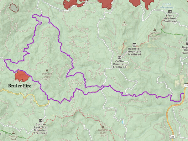
DownloadHighlights & Remarkable Spots
North Santiam River / @Start
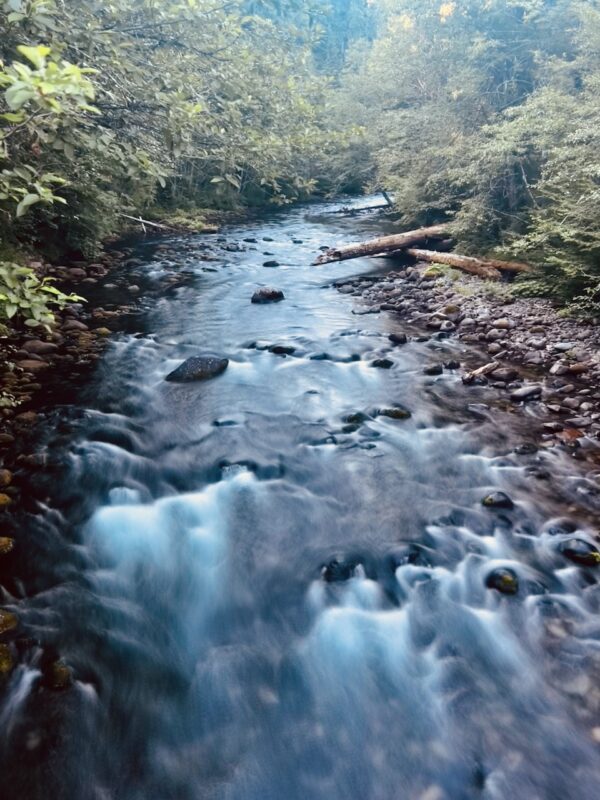
The North Santiam is host to a variety native fish species: Rainbow Trout, Cutthroat Trout, Mountain Whitefish, Winter Run Steelhead and Spring Chinook Salmon. Historically the river once produced more salmon and steelhead than any Willamette tributary, fully two-thirds of the Willamette’s winter steelhead and a third of its spring Chinook. Today, however, the river is impounded at the Detroit/Big Cliff dam complex and marks the natural end to upstream migration of anadromous fish species. Reconstruction of the Minto Fish Trap Facility just below Detroit/Big Cliff dams was completed in 2013 at a cost of over $28 million. Native species (Spring Chinook and Winter Steelhead) are now trapped and hauled above the dams and have access to historical spawning habitat. [Native Fish Society]
Bruler Fire / ~ Mile 13
The 2021 Bruler Fire “was a gut-punch to the area, as it was one of the few locations that didn’t burn in the massive September 2020 Beachie/Lionshead fires. Together, these fires devastated nearly 398,042 acres of land in Oregon and were part of one of the most severe wildfire seasons in the state’s history.
“A helicopter dropped water on the fire to cool the interior while while ground crews attacked the fire directly, digging hand lines for containment. Lines were further strengthened by two dozers, working to keep the fire within a small footprint.”
Fire crews are able to reach this fire on the ground due to lots of forest roads in the area unlike the Beachie Creek Fire, which was too remote for firefighters to reach. The Bruler fire was contained at ~ 200 acres [Statesman Journal]
The Needles Basalt Towers
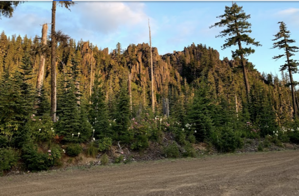
“What makes the basalt towers so amazing is driving on forest roads, thick with trees, when bam, you round the corner and there they stand, tall and majestic. Just slightly down the road headed east is a great view of Mount hood, and just a little further east is Mount Jefferson.” [2019, Cindy Boggs]
Pinnacle Peak Falls / ~ Mile 24.5
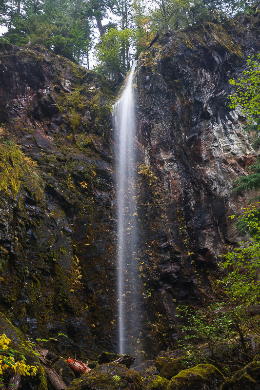
Pinnacle Peak Falls is a free-falling plunge style waterfall of 145 feet in height, occurring along seasonal tributary to Lost Creek near the divide between the North and Middle Santiam Rivers. When the small stream is flowing at peak levels, the falls appear as a narrow plume of spray lofting into an alcove adjacent to the road. By late spring however the stream shrivels up and turns into a narrow wall of dribbles before (likely) drying out completely during the summer. [Northwest Waterfall Survey]
When We Like to Ride This
Early Summer through Fall
Terrain & Riding
As part of the Motown series near Detroit, the Brickhouse route doesn’t mess around. The start has no warm up … you leave the campground, cross a bridge … and then head straight up (10% +). Big ponderosas framed with ferns and rhododendrons.
In 4 miles you climb 1300 feet. It’s a steep uphill, so you have plenty of time to spot the few potholes and mark them for the descent. For the next 6 miles you roll up and down …. time to enjoy the big views to the north.
When you hit the gravel, you’ll need to dig a little deeper … until you reach the Basalt Cliffs which are looming over the road. Now you are done with the first climb …
The long “squishy” downhill (8 miles, 2400 feet) will test out your brakes and technical skills. At the bottom you run into a paved road which will give you time to shake out the cramps in your hands from braking.
Soon it’s time to climb again (2000 feet in 9 miles). You wind up through more forest with some limited exposure to the sun.
When you hit the pavement, it’s time to blast back to the cars. Remember those sparse potholes on the hill climb at the start? It’s the same road, so give it a double look.
The Start
Junction of Highway 22 and Straight Creek Road.
Food & Water
- None.
Route Notes
There is dispersed camping at the start near the river. But, only camp here if you have a mechanism to collect pee and poo. Peeing on the ground and pooing into a cat-hole is not an acceptable alternative when so near a river where water quality can be affected. A van alternative is something like a Trelino portable composting toilet.
Ridden and Reviewed by:


 Behind every route is scouting, mapping, storytelling, and a whole lot of pedal power.
Have you ridden this route? Got a question? Join the discussion!