Spider Tom


 - 3")
 - 12")
 - 10")
 - 11")
 - 8")
 - 9")
 - 5")
 - 7")

 - 16")


Caution! We do not provide turn-by-turn directions in our GPX files. Those are auto-generated by your bike computer and are usually less than 70% accurate. Learn more.
For help loading a GPX file onto your bike computer, go here.
DownloadHighlights & Remarkable Spots
Canelo Hills / ~ miles 0 to 20
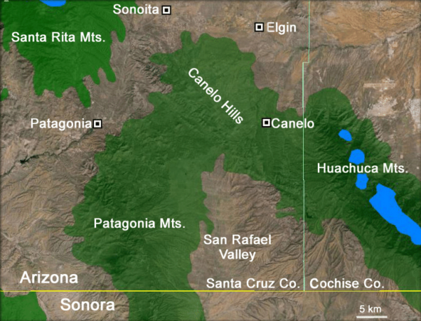
The Canelo Hills have a rich cultural history, with evidence of human habitation dating back thousands of years. The area was once inhabited by various indigenous groups, including the Hohokam, Mogollon, and Apache, who left behind artifacts such as pottery, tools, and rock art.
The southern end of the Canelo Hills contain evidence for a volcanic caldera, the Parker Canyon Caldera. This caldera is mapped as a kidney shaped feature stretching from just north of Canelo Pass some 15 miles to the southeast into the Huachucas and underlying the eastern portion of the San Rafael Valley. The Jurassic volcanics in the area consist of rhyolite welded tuff containing large exotic blocks of limestone, quartzite.
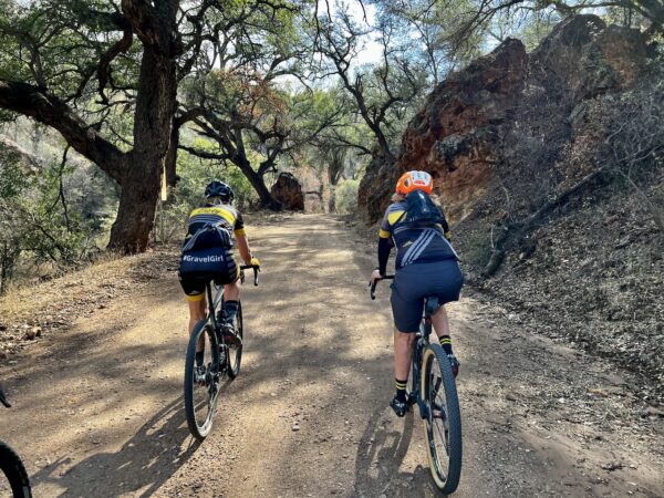
Arizona Trail / ~ miles 3 to 21
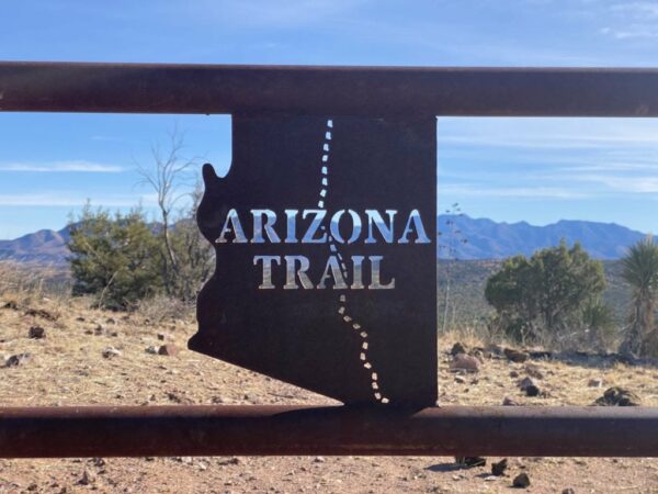
The sinlge-track trail throughout this route is part of the The Arizona Trail system. The AZT is an 800+ mile recreation trail from Mexico to Utah that climbs and descends from one Sky Island mountain range to another, traversing biomes ranging from mountain ranges to canyons to deserts and forests. About 73% of the trail is on National Forest lands, with the remaining 27% a mix of Bureau of Land Management, National Park Service, Arizona State Parks, and county, private, and municipal lands.
Patagonia Train Track Trail / ~ miles 21 to 26
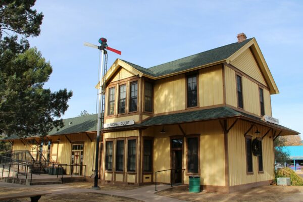
The establishment of mining camps and cattle ranches in the late 1800s created a need for rail transportation, which led to the construction of the New Mexico & Arizona Railroad in 1882. The railroad connected Nogales (to the south) to the mainline of the Southern Pacific Railroad in Benson (to the north). The railroad became a major factor in the area’s development, as it allowed ranchers to ship up to 3000 head of cattle per day and it allowed the mining industry to transport ore. The railroad also played a significant role in the creation of new towns, including Patagonia, which was founded in 1896 and named after Rollin Rice Richardson. The railway was also used by military officers during the final campaign against Geronimo in 1886 to quickly move troops and equipment to their destination. Picture of the old railroad depot in Patagonia. [Green Valley Recreation Hiking Club]
Patagonia / ~ mile 26
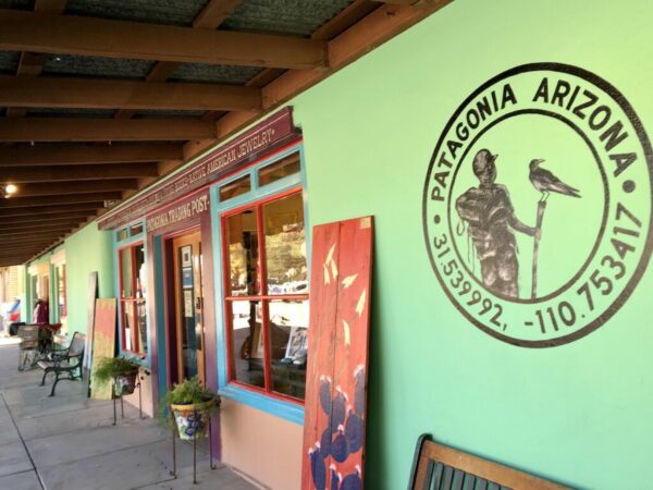
Archaeological evidence suggests that this area was inhabited by various Native American tribes for thousands of years prior to the arrival of European explorers. In the 16th century, Spanish explorers arrived and established missions to convert the Native Americans to Christianity. However, these missions were abandoned by the early 18th century. In the mid-19th century, American prospectors and miners began to explore the area in search of gold and silver. This led to the establishment of several mining towns in the region, including Harshaw, Duquesne, and Mowry. Patagonia itself was founded in the 1880s as a railroad town, serving as a transportation hub for the surrounding mining communities. Today, the town is a thriving community with a rich history and a strong commitment to preserving its cultural heritage. [Wikipedia]
Harshaw Creek Canyon / ~ mile 29 to 33
Harshaw Creek is a 15-mile stream in that flows towards Patagonia where it joins with Sonoita Creek. It is named after David Tecumseh Harshaw, who settled along its banks in the mid-1870s. The creek and its tributaries were a hub of gold and silver mining activity in the late 19th and early 20th centuries, and several towns and mining camps sprang up in the area during this time. The creek flows through a narrow, steep-walled valley with a riparian corridor of cottonwood, willow, sycamore, and other plants. (Absolutely gorgeous!) The creek is mostly ephemeral, and its flow is greatest after the summer monsoon and winter snowstorms.
San Rafael Valley / ~ miles 33 to 44
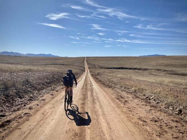
The valley represents one of the finest stands of native grassland in the State. These grasslands have not suffered the problems of shrubs and cactus invasion nor have they been taken over by exotic plant species that affect so much of this vegetation type elsewhere in the State and the Southwest. The valley extends over 90,000 acres and lies at the headwaters of the Santa Cruz River between the Patagonia Mountains, Huachuca Mountains, and the Canelo Hills. Marshy springs feed the river and the floodplain that includes several swampy stretches. The valley is home to a wide variety of plants and animals. White-tailed deer, mule deer, and javelina are the most common species. Pronghorn antelope were reintroduced in the valley in the 1950s and the herd now numbers about 60 animals. Rare species found in this area include Canelo lady’s tresses, Mexican garter snake, Huachuca tiger salamander, Gila topminnow, Gila chub, Sprague’s pipit, and Baird’s sparrow. Cattle ranching has been the predominant activity in the San Rafael Valley for approximately 175 years. The valley’s pristine condition is due largely to the land stewardship by the ranchers. [Arizona State Parks]
When We Like to Ride This
Fall through spring. We think winter is ideal.
Terrain & Riding
The overall gist of this route is a few-mile warm-up on a superhighway of gravel, then 18 miles of tough Arizona trail, then an old railroad grade trail to Patagonia, then a few miles of paved, and then back to more amazing, easy gravel roads. We designed the route so you will get in a warm-up, hit the technical stuff, then spin your way home.
The Arizona Trail (Canelo Hills West passage) spans from mile 3 to around mile 21 and is rated as an intermediate mountain biking trail. This is the crux of the route! It consists of both single-track and double-track terrain, with some sections being rocky, loose, and difficult to navigate. Although the elevation profile may appear to be entirely downhill, the trail actually includes 2500 feet of descent and 1500 feet of uphill gain. For the most part, you are working yourself downhill through rolling grasslands, yuccas, and pinyon pines. It is remote, with no bailout points and no access points. There is little to no cell phone reception. You will want an adventure bike with at least 50 mm tires. When you’re about to cry “uncle”, it’s over and in front of you is the super flat old railway grade trail.
At ~ mile 21.5 you pick up the old railroad grade and make your way to the town of Patagonia. This riding, much of it a mix between single-track and double-track, is much easier (technically and aerobically) than the last 18 miles of the Arizona Trail.
Refuel in Patagonia at mile 26 if needed. Leave Patagonia on a paved road that is seeing more and more truck traffic due a mine further up road in the mountains.
At mile 29, you turn left Harshaw Creek Road [gravel]. These next 4 miles are some of the most beautiful miles in the Patagonia area. Big Cottonwood trees, a rock canyon, and the creek.
At mile 37.5, you top out after a short step pitch lifting you out of Willow Spring Canyon. This is a yeehaw! spot. In front of you is the easy descent into San Rafael Valley. So beautiful! So much fun!
Just after mile 41, stay straight and make a quick corner left followed by a corner right (it feels like you are tracing a property line), and then gradually bend north. In front of you is the Canelo Hills; if you look closely, at about the 11 o’clock position, you can see the road cutting up the right to left to Canelo Pass, your destination. The climb is about 4 miles in length with 500 feet of gain; near the top is the steepest. But … it is never brutally steep. This is one of those climbs that you anticipate to be harder than it actually is. A good thing!!
As you near the pass and climb in a northwesterly direction, off your left shoulder is a sweeping view of the Canelo Hills, backdropped by the San Rafael Valley backdropped by the Patagonia mountains. When you see the Canelo Pass sign, most of the work for the day is done. From here, it is 3.5 miles back to the cars with a net loss of 500 feet and a couple of short popper hills, adding 100 feet in gain.
With all that said, Spider Tom, the technical guru of the Dirty Freehub Team, rode (yes, rode!) 99% of the terrain. His bike was a Moots Routt YBB with 50 mm Gravel King tires. Captain O of the Dirty Freehub team cleaned about 95% of the course on his Salsa Cutthroat with 55 mm Fleecer Ridge tires.
But no hate mail if you don’t like the gnar … we warned you!!
The Start
A dirt pull out on the west side of the road, Highway 83, just before a left hand 90 degree bend.
Food & Water
- ~ mile 26 / Patagonia. There are several stores and shops in town for food & water.
Route Notes
It may be tempting to start this route from Patagonia, but we do not recommend that. The last half of your day will be the most technical and demanding (by, a lot!) Not always a good thing!
We recommend knee-high socks to save yourself from a lot of the close-in prickly stuff. With heavy plant growth, the Arizona Trail section can be a real challenge, both riding and navigating.
The Arizona Trail sector of this route really demands an adventure style gravel bike. Something with 50+ mm tires, low gearing, and a geometry closer to a mountain bike than a road bike. I rode this route on Salsa Cutthroats with 2.1″ (55 mm) Fleecer Ridge tires (by Rene Hearse), tubeless with CushCore inserts. The gear ratio is about 0.9.
Note, we have updated this route (v2.0) as of January 2023 to include a “new section of the AZT” and to include the old railroad grade into Pataonia.
Route Options
You can shorten the ride by eliminating the stick of the lollipop and starting at the Arizona Trail Parking lot. (Lat / Long: 31.512847, -110.557701) We did not opt for this option, in that you get no time to warm up your legs before embarking on tough, demanding terrain. And … the drive to the parking area is only slightly quicker than being on your bike!
Love Where You Ride! Learn More
![]() A majority of this route is on sweet riding section of the Arizona Trail (AZT). Great trails like the AZT don’t happen by accident. They take planning, building and maintenance. We encourage you to give back to your local trails organization or the Arizona Trail Association by volunteering for a work party or making a donation. Let’s continue to build on our success of great routes …. for the community, by the community!
A majority of this route is on sweet riding section of the Arizona Trail (AZT). Great trails like the AZT don’t happen by accident. They take planning, building and maintenance. We encourage you to give back to your local trails organization or the Arizona Trail Association by volunteering for a work party or making a donation. Let’s continue to build on our success of great routes …. for the community, by the community!
Keep it Local! Learn More
Ridden and Reviewed by:


 Behind every route is scouting, mapping, storytelling, and a whole lot of pedal power.
Have you ridden this route? Got a question? Join the discussion!