Devils Cash Box


Caution! We do not provide turn-by-turn directions in our GPX files. Those are auto-generated by your bike computer and are usually less than 70% accurate. Learn more.
For help loading a GPX file onto your bike computer, go here.
DownloadHighlights & Remarkable Spots
Anza Trail / Gravel & Dirt Trail / ~ Miles 0 to 4
Before you even begin, walk across the parking lot to Canoa Lake and take in the view. It’s lovely. Your destination is just to the right of Elephant Head.
Now, ride to east end of the parking lot on the south side of the lake, hop the low gate, and take the Anza trail south. It is a wide, improved, and maintained gravel trail meandering along the desert floor through grasses and cactus. It makes a great way to start a ride and spin the legs (you will also enjoy it a lot on your return).
Juan Bautista de Anza, Captain of the Tubac Presidio, left Culiacan, Mexico, in the summer of 1775 on a journey that showed it was possible to transport livestock, goods, and people overland from Sonora, Mexico to new settlements in Northern California. The Juan Bautista de Anza National Historic Trail, authorized by Congress on August 15, 1990, recognizes the story of this journey. [Trailside Kiosk]
To your left, the pyramid-shaped buttress is Elephant Head, and just to the south and a bit higher than this is a series of radio towers. That is your destination. And … above this and higher yet is the Fred Lawrence Whipple Observatory atop Mt. Hopkins. At mile 4, you come to the Elephant Head parking lot. Meander through the lot to the paved road and go east.
Mt Hopkins Road / Paved Road / ~ Miles 4 to 12
This second sector is a gradual paved climb [Elephant Head road to Mt Hopkins road] with distant but growing views of Mt Hopkins and the Santa Rita Mountains. The pitch ranges from 1 to 4%, the road surface is rough, chipped pavement with some frost heaves. This is the time to get your legs ready for the more rugged and steeper climbing ahead.
Devils Cash Box Climb / Gravel / ~ Miles 12 to 16

At mile 12, turn left onto a gravel / dirt road. It pitches up quickly. This is not your smooth, fast gravel! This is a typical Arizona desert unpaved road. It will vary from hard pack to loose over hardpack, to loose, to rutted, to embedded rock with a cobblestone-like texture.
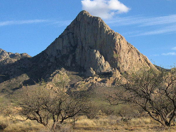
0.6 miles into the sector, you pass through a wash marking the western terminus of Agua Caliente Canyon. The ride parallels the canyon for approximately next 2 miles. Along this stretch, look right for a series of small peaks (5); this is Devils Cash Box. As you climb higher, Juniper trees become dominant on the hillside.
At ~ mile 13.2, cross through the Aqua Caliente Canyon proper. This marks the beginning of the crux of the ride. It is steep [more than 10%] and loose in many places. When you make a sweeping right turn, just after at a parking pullout, the views explode! Diagonally you cut up the ridge while looking south across the valley to Tumacacori Highlands of the Sky Islands. (Micro-video)
The Tumacacori Highlands comprise three small, closely spaced mountain ranges (Pajarito Mountains, Atascosa Mountains, Tumacacori Mountains) on the United States and Mexico border just west of Nogales. Although unimposing in elevation, the Tumacacori Highlands have sharp ridges, steep slopes, and rocky cliffs that limit the number of roads and give the area a feeling of remoteness. The vegetation is scattered evergreen oak woodlands on north-facing slopes with scrub-grasslands on south-facing slopes. Mesquite and acacia shrubs are common, as are agaves and sotols. [US Forest Service]
At ~ mile 15, you come to a 180 bend that we termed “eye in the sky” corner. Sometimes Border Patrol is parked here with a dedicated surveillance vehicle. This spot is a fantastic viewpoint. Some may want to call this the end of the ride [Gravel Girl did], and for those that don’t, it is about to get very steep. And remember, you must go down what you go up!
Climb the first concrete pad; it pitches up to nearly 20%. Then grunt up the next short gravel segment to the second concrete pad — Captain O was resigned to walking this! The second concrete pad pitches up beyond 20%, but … at the top of this pad, the riding becomes more manageable. Still steep, but manageable. The views are worth it. Elephant Head. Mt Hopkins. Green Valley. The last bit to the towers is slightly anti-climatic, but you will feel like a rock star.
The Return / Gravel, Paved, & Trail / ~ Miles 16 to 32
Now, return in reverse. For the gravel descent, we lowered our seats and reduced our tire pressures.(Micro-video) We coasted down the paved sector, (Micro-video) spinning the pedals periodically, and finished up, zipping along the Anza Trail. Every so slightly downhill, desert views, and Elephant Head and Mt Hopkins in the distance: A great way to finish!
When We Like to Ride This
Fall through spring, when the temperatures are more moderate.
Terrain & Riding
There are extremely steep and loose pitches on this route, especially near the summit. Advanced technical riding skills are a must. Cell phone reception is limited but periodic.
The Start
Historic Canoa Ranch (county park)
Food & Water
- None.
Route Notes
For this route, you will want (need) low gearing, something lower than 0.90 gear ratio, and wide rubber, 50 mm or more, and bigger nobs. Others may prefer a hardtail mountain bike versus a gravel bike.
Ridden and Reviewed by:


 Behind every route is scouting, mapping, storytelling, and a whole lot of pedal power.
Have you ridden this route? Got a question? Join the discussion!