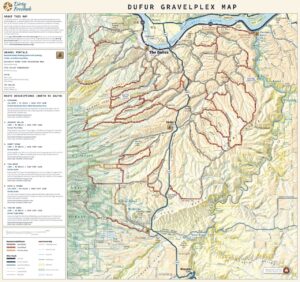
The Dirty Eagle


Caution! We do not provide turn-by-turn directions in our GPX files. Those are auto-generated by your bike computer and are usually less than 70% accurate. Learn more.
For help loading a GPX file onto your bike computer, go here.
DownloadHighlights & Remarkable Spots
Elkhorn Mountains / ~ Mile 2
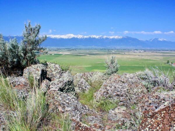
The Elkhorns are part of the Blue Mountains but are much more rugged and alpine than most of the Blues. The range features jagged granite peaks, cirque basins, and classic glacially carved landscapes — a bit unusual for Oregon, which is better known for its volcanic peaks like the Cascades.
The Elkhorns are well known for their population of mountain goats, which were reintroduced to the range in the 1980s.
The Elkhorns were a hub of gold mining in the 1800s. [Ref: Wikipedia and Summit Post]
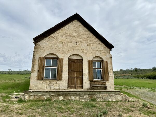
Stone Building / ~Mile 4
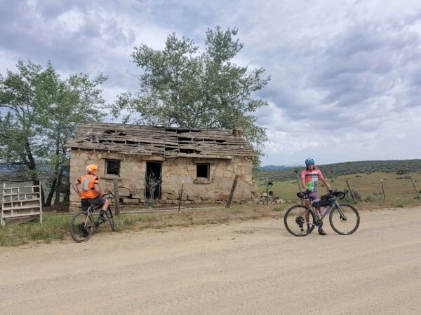
The history of the small stone cabin at this site is hard to trace with certainty, but it may have once served as a stage stop between Pine Valley and Baker City. Today, it offers a scenic photo opportunity with the Wallowa Mountains rising in the background.
Wallowa Mountains / ~4
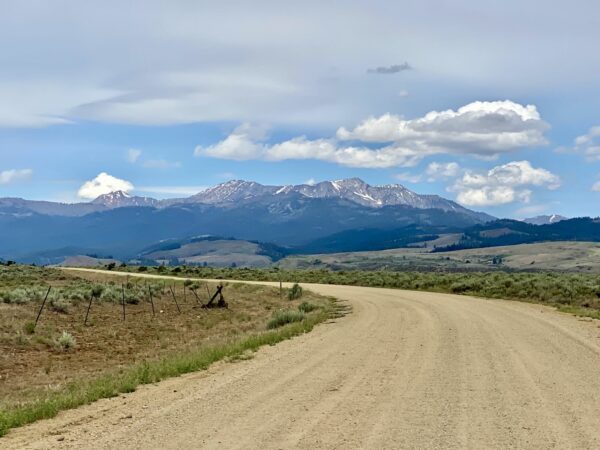
These mountains are some of the most complex in Oregon. 120 to 160 million years ago during a time of intense volcanic activity a massive granite bedrock formed called the Wallowa Batholith. Over millions of years, this granite was blanketed by flows of Columbia River basalt, adding another layer to the region’s geologic tapestry.
Fast forward to the last ice age — the late Pleistocene epoch — when colossal glaciers bulldozed their way through these valleys. The movement of ice sculpted deep U-shaped valleys and left behind a spectacular array of moraines and cirques. As the glaciers melted, torrents of water carried rock and soil downslope, building up fertile valley floors with layers of glacial till and delta deposits.
White Mule's Ears / ~Mile 6
White Mule’s Ears tends to thrive in mountain meadows, sagebrush steppe, and open forests. Finding big stands of it often means you’re in a relatively intact, native plant community — a good sign that the local ecology is still functioning well.
This plant has large, lance-shaped leaves that look like the floppy ears of a mule. These leaves can grow up to a foot long and often create big green mats that stand out among the grasses.
Its early blooms provide nectar for bees and other pollinators right as they emerge in spring. Mule deer and elk may browse its young leaves.
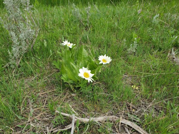
Arrowleaf Balsamroot / ~Mile 7
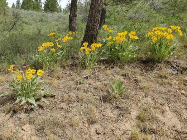
Arrowleaf Balsamroot is also known as “Oregon sunflower”.
The leaves are arrow shaped, meaning that the blades are triangular and pointed. They can be from two-thirds to one and two-thirds of a foot long. The leaf blades are fuzzy, especially on the top side.
A large, deep, thick taproot completes the name, having a diameter the width of a hand and a branching root going some feet deep. The thicker portions are covered with bark. The balsam portion of the name refers to a resin in the root.
Sparta / ~ Mile 8
In the late 1800s, Sparta was a prosperous mining town that yielded $677,000 worth of gold from lode mines. It had three stores, a temple, a bordello, a doctor and multiple gambling halls. Sparta Chinatown had over 1200 Chinese immigrants who worked primarily as laborers and miners. A Chinese cemetery on a ridge close to town still has pits marking the sites of remains that were disinterred and returned to China by the Chinese Consolidated Benevolent Association.
Still standing in Sparta is the general goods store originally built by Sigmund Heilner in 1872. Sigmund and his brother set up and operated the general store and banking business under the name E. D. Cohn & Company.
Two state view / ~Mile 12
Three peaks come into view at ~ mile 12. From right to left they are Big Lookout Mountain in Oregon, Sturgill Peak and Cuddy Mountain in Idaho. Sturgill Peak is the highest mountain in the Hitt Mountain Range at almost 7,600 feet. Cuddy Mountain is the tallest peak in the Cuddy Mountain range at over 7,800 feet.
New Bridge / ~Mile 18
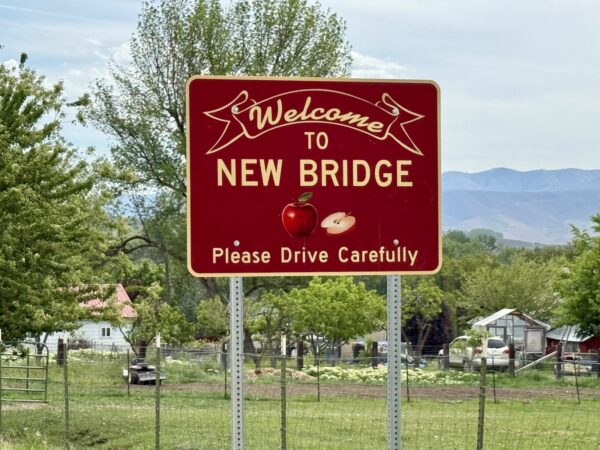
New Bridge was established in 1878 with the opening of its post office, where Joseph Gale served as the first postmaster. The community developed along Eagle Creek, near a significant bridge constructed during pioneer times, which gave the town its name.
During its peak, New Bridge supported a variety of industries, including a fruit and vegetable cannery, a box factory, and a packing shed for apples. It also served as a hub for agricultural trade, supplying goods from Eagle Valley to miners in the nearby Sparta area. [Wikipedia]
Town Gulch Fire of 2024 / ~ Mile 19 to 28
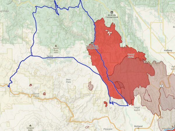
The fire ignited along Eagle Creek, about eight miles northwest of Richland, and rapidly expanded due to hot, dry, and windy conditions. It advanced southeast toward New Bridge and Pine Valley, burning downslope in heavy timber.
Start Date: August 5, 2024
Cause: Lightning
Total Area Burned: Approximately 18,215 acres
Structures Damaged or Destroyed: 4
Personnel Involved: Over 300 firefighters
Eagle Creek / ~Miles 18 to 26 and 36
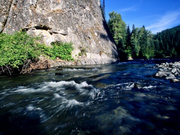
Eagle Creek begins high in the Eagle Cap Wilderness, rushing down steep, rocky slopes shaped by glaciers. From its alpine headwaters, the creek descends into Eagle Valley near New Bridge, where it slows and meanders through open meadows and farmland. Here, the landscape softens, with ponderosa pine on drier slopes and basalt cliffs framing the valley. The creek’s clear pools and riffles reflect a transition from wilderness to working ranchlands.
When We Like to Ride This
We love this route in late spring and early summer, when the creeks are full and the wildflowers are in bloom. Keep in mind that about half of the route is very exposed to wind and sun. If you plan to ride it in the summer, aim for an early start on a cooler day.
Terrain & Riding
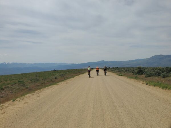
Sparta Sector / Mile 0 to 17
This section starts climbing immediately — about 4.2 miles with an average gradient of 6.5% and roughly 1,400 feet of elevation gain. It’s a two-stepped climb with a short break in the middle, featuring sustained sections with gradients up to 11%.
As you climb, you’ll catch distant views of the Elkhorn Mountains to the west. When you reach the top and the Wallowa Mountains explode into view (to the northeast), the landscape shifts from rolling sagebrush and grasslands to a mix of junipers and ponderosa pines. Around mile 10, the terrain opens up again into sage and grasslands before the road drops into a fun, fast, winding descent that leads you into the small town of New Bridge.
Eagle Valley Sector / Mile 17 to 33
As you ride through New Bridge, you’ll encounter the only paved stretch of the route. Here, you’ll also cross Eagle Creek for the first time — a majestic river that roars and tumbles through numerous rapids along its course. From mile 17 to 25 you parallel Eagle Creek up Eagle Valley past scattered ranches and farms and finally into the the Wallowa-Whitman National Forest (~ mile 23). Now the terrain is more mountainous with creeks and big Ponderosa and Douglas-Fir trees.
This sector features the longest climb of the day: about 7.5 miles with an average grade of 4.5%, beginning around mile 25. This is also where Eagle Creek subtly splits to the left and from miles 25 to 29, you parallel Little Eagle Creek as you continue to climb.
At around mile 29, you’ll come to a Y intersection. The main road — the one with the most traffic — veers to the right. Your route branches left, taking you onto a smaller, more primitive road. This shift is a welcome change from the wide gravel roads you’ve been riding so far, adding a bit of spice and adventure to the journey. This sector is only 4 miles long, ending with a steep downhill.
Empire Gulch – Collins Road Sector / Mile 35 to 42
At ~ mile 35 you cross Eagle Creek for the second time. Stop and take a moment to witness the beauty and force of the river. After paralleling Eagle Creek for about 2 miles, you turn right and up onto the last major climb of the day, ~ 3.5 miles at an average of 6%, with some pitches of 9%. Just before mile 40, you turn left onto a larger gravel road (NF-70) and top out a short time later.
The Downhill Return / Mile 40 to finish
Here you gradually leave the Ponderosa forest behind and re-enter the rolling hills with sage and grasses. There are a few short uphills but the rest of the ride is primarily downhill. At approximately mile 46 you return to Sparta Lane with a fast, fun descent back to the starting point. Views to the Elkhorn and Wallowa Mountains abound.
—
Overall, the road quality is very good, proper hard-packed gravel roads. However, you can expect some washboard. The roads in the National Forest are the most course and primitive, but not severely degraded or extremely demanding.
The Start
Dirt pull-out at the intersection of Baker-Copperfield Hwy #86 and Sparta Lane.
Food & Water
- Water can be filtered from Eagle Creek, after New Bridge, at ~ mile 22
- The city of Richland, Oregon is ~3 miles south of New Bridge on New Bridge Road. Richland has a cafe, bar and grill and a small grocery store
- "Drinking water may be seasonally available" at Eagle Forks Campground at ~ mile 25, according to the Forest Service website
Route Notes
We recommend a red, blinking light with a radar detector for this route. Sparta Lane has light traffic from residents and workers on the surrounding ranches and farms. As a guest in this community be friendly. A simple wave or a brief chat with a farmer or rancher is often appreciated and can make your experience even more enjoyable.
To learn more about rural riding etiquette give a listen to our podcast with Darla K, and eastern Oregon rancher. She and her husband operate a 1000-acre farm that has been in the family since 1886.
You may come across cattle grazing freely along the route. Before you ride into the herd like a gravel cowboy, take a moment to check out our resource page on Cows—it’s full of tips for passing safely.
A few things to consider before approaching: Is there a bull in the bunch? Any protective mommas with young calves? These factors matter.
The worst approach? Charging through the herd while whooping and hollering like it’s a rodeo. That only stresses the animals and can lead to unpredictable (and unsafe) behavior. A calm, measured approach is best. Sometimes you may even need to stop, remove your helmet and sunglasses so you look more human, and walk your bike past the herd.
Think about it: If a pack of six strange creatures with giant heads, bug eyes, and four spinning limbs (two wheels + two legs) came speeding toward you… wouldn’t you be tempted to run—or fight?
We have labeled the route as remote, but much of the route is along rural farm and ranchlands. The remote sector is from mile 25 to 44, in the Wallowa-Whitman National Forest.
The route rides well in both directions — we’ve ridden it both ways and honestly can’t pick a favorite.
Route Options
Bikepacking Option
The route can be split into a 2-day adventure by making a stop at Eagle Forks Campground at ~ mile 25. The campground is located just below the split between Eagle and Little Eagle Creek.
Love Where You Ride! Learn More
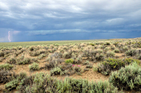
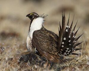 There are several sectors — from miles 0 to 4, 9 to 17, and 44 to the finish — where you’ll be riding through classic sagebrush steppe, the natural habitat of the greater sage-grouse.
Sage-grouse depend on large, unbroken tracts of sagebrush for nesting, feeding, and shelter throughout the year. Because of this, they are considered an indicator species—their presence signals the overall health of the sagebrush ecosystem. When sage-grouse populations decline, it often points to habitat loss or fragmentation that affects many other species, including mule deer, songbirds, and insects.
Local farmers and ranchers have partnered with the state of Oregon to protect the greater sage-grouse through the Sage-Grouse Candidate Conservation Agreement with Assurances (CCAA). This voluntary program is a collaborative effort that helps landowners protect and improve sage-grouse habitat while also supporting the economic viability of local farms and ranches and preserving the rich ranching traditions and agricultural lifestyle of Baker and Union counties.
Videos
The Greater Sage Grouse – One of Nature’s Greatest Dancers
In this 2-minute video, discover the beautiful, bold, and boastful Greater Sage-Grouse. Watch how the males inflate their brightly colored air sacs to create sounds that can travel up to three kilometers, attracting females to their display grounds. By the BBC.
Podcasts
Untangling the Geological History of the Wallowa Mountains
The Wallowa Mountains in NE Oregon have the most complicated and longest geological history of any range in Oregon. In this podcast, we talk with Dr. Kim Ely, a geologist, about this unique and beautiful area. Learn how to “untangle what you see” when riding in the Wallowas!
Be Informed!
Keep it Local! Learn More

Ridden and Reviewed by:


Have you ridden this route? Got a question? Join the discussion!