Old Milwaukee


Caution! We do not provide turn-by-turn directions in our GPX files. Those are auto-generated by your bike computer and are usually less than 70% accurate. Learn more.
For help loading a GPX file onto your bike computer, go here.
DownloadHighlights & Remarkable Spots
Palouse to Cascades State Park Trail / ~ Miles 0-15 and 25 to 40
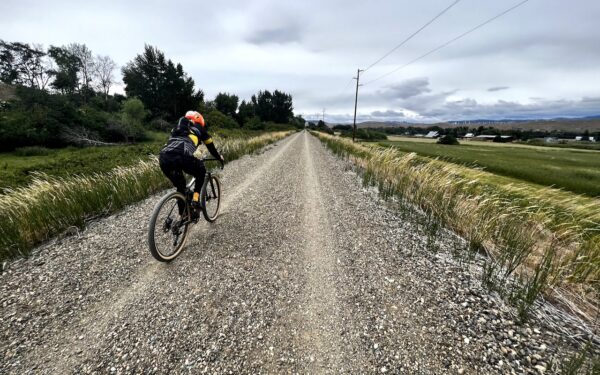
The 250-mile Palouse to Cascades State Park Trail stretches from North Bend, WA to the Idaho border, tracing “the historic route of the Washington State section of the Milwaukee Road, a railroad that once stretched over 2,300 miles from Chicago to Tacoma … The route’s rapid construction was enabled by a highly mechanized approach using steam shovels and narrow-gauge construction railroads, which required fewer laborers than earlier railroads. In 1911 railroad leaders began an ambitious first-of-its-kind project to convert long sections of the route to fully electrified lines. This advance allowed for carrying heavier loads with fewer locomotives and staff and required less maintenance than steam locomotives.” The railroad closed in 1980 and efforts to convert the line to a trail began shortly after. [Washington State Parks]
Columbia River Basalt Formations / ~ Miles 3 to 13 and 27 to 37
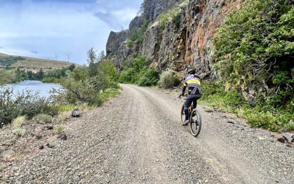
Most of the eastern half of Washington is blanketed by an estimated 10,000 feet of Columbia River Basalt Group lava flows that erupted between 16.7 and 5.5 million years ago while this edge of the North American plate drifted over the hot spot now believed to be percolating under Yellowstone National Park. The basalt would ooze out of cracks in the earth’s crust and often cooled into columnar structures resembling bunched-up standing French fries. Evidence of these basalt flows can be seen along this stretch of the trail. [USGS.gov]
Yakima River / ~ Miles 3 to 13 and 27 to 37
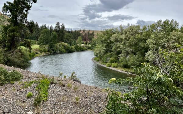
“From Keechelus Lake near Snoqualmie Pass, the state’s longest river of origin descends from rugged mountains through a scenic basalt canyon to an agricultural valley floor that culminates in the near-desert steppe at its confluence with the Columbia River. Its upper reaches host large herds of elk and deer and exotic wildlife that includes wolverines, mountain lions, and one of Washington’s newest wolf packs. Downstream, wild trout are the main attraction, but salmon that had been absent from the Yakima River Basin for more than 100 years due to impassable dams are making their return in increasing numbers.” Another reason to celebrate the Yakima: “The premium hops used in most of the nation’s craft beers are one of the major crops sprouting up from the irrigated soil in the Yakima River Valley” [American Rivers]
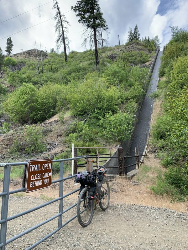
Tunnels 46 and 47 (0.6 mile in between) / ~ Miles 4.4 and 34.6

The Thorp trailhead for the Palouse to Cascades State Park trail is located at a former depot location for the Chicago, Milwaukee, St. Paul, & Pacific railroad and as you begin riding, you’ll be following the path of this railroad even as it passes through old railroad tunnels. The first tunnel is #46 and is 0.1 mile long so a light may not be necessary as long as you allow your eyes to adjust. The second tunnel, #47, is 0.3 miles long and slightly curved so having a light for this one is a good idea. Note that in either tunnel, there could be larger-sized rocks on the trail so caution is advised.
Irrigation Return / ~ Miles 10 and 30
“Out of sight on the ridge above the trail is the Main Canal (irrigation) which starts at Lake Easton. Between Tunnel 47 and the Ponderosa Campground two causeways are used to return water from the canal to the Yakima River. At high flow rates these make impressive manmade waterfalls.” [WTA.org] The Yakima River provides irrigation water for 175 miles of agricultural acres along its flanks. “Yakima County ranks first among all counties of the United States in the production of apples, mint, and hops. Principal crops are fruit, vegetables, forage, hops, and mint.” [USBR.gov]
South Cle Elum Depot and Rail Yard / Miles 18.3 and 21.7
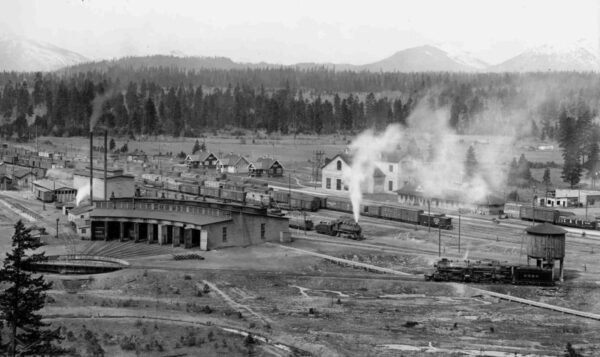
The South Cle Elum Depot and Rail Yard were “established in 1909 as a division point for crew changes and train servicing on the Chicago, Milwaukee, St. Paul and Pacific Railroad’s Coast Division. It included a restaurant (or “beanery”), a roundhouse where eight trains could be serviced, an icehouse, and three bungalows. The railroad was powered by coal from nearby mines, and its presence helped build the towns of Cle Elum and Roslyn. The rail yard and remaining buildings, including the depot, substation, and bunkhouse, were listed on the National Register of Historic Places in 2003.” [Mountains to Sound Greenway] If your timing is right, you could grab lunch at Smokey’s Bar-B-Que which operates inside the original beanery and has the same operating hours as the exhibits inside the Depot. There is also an interpretive trail showcasing old rail yard structures and ruins.
When We Like to Ride This
Spring and fall when temperatures are more pleasant and flora is at its prettiest (lots of greenery and flowers in spring, autumn foliage colors in fall).
Terrain & Riding
With very little elevation gain and a combination of pavement and gravel rail trail, there is little need for advanced gravel riding skills on this route. In some spots on the Palouse to Cascades trail, the gravel can be a little deep and sandy and other spots may have some chunky rocks here and there but otherwise it’s very untechnical and most any width of gravel tire will do.
The route leaves the trail at mile ~15 to add variety by getting a little higher up – not much, but enough for some unobstructed views of the mountains. This part is paved but typically pretty quiet in terms of vehicle traffic. If you’d prefer to stay on the trail, you can do just that and will intercept the route again when it comes into Cle Elum.
Winds in this area can be persistent, intense, and energy-sapping. They put windmill farms up in them thar hills for good reason! Prevailing winds are typically (but not always – so we advise checking the forecast) out of the west and usually kick up significantly in the afternoon. We suggest getting an early start from Thorp so that it’s not too gusty when you’re heading into the wind and then you can enjoy the tailwind on the way back. Also note that in warmer months, it gets very hot out on the Palouse to Cascades trail and shade cover is sparse so prepare accordingly with fluids and sunscreen.
The Start
Palouse to Cascades State Park Trail Thorp trailhead. Dirt parking lot. Discover Pass required. Pit toilets.
Food & Water
- ~ Mile 20: Cle Elum. Restaurants, gas stations, coffee shops.
Route Notes
The Palouse to Cascades trail is a Washington State Park. We believe it is important to support the Washington State Park system and one way you do this is by purchasing the Discover Pass. (It is required to park at the trailhead.) The Discover Pass supports the planning, development and maintenance of parks.
For the tunnels you will want to a bright front facing light. An iPhone light is not nearly enough light! Trust us on this!
Route Options
This route highlights one of the more scenic sections of the Palouse to Cascades trail. If you are looking for something a bit shorter, start at the Thorp Trailhead but turn around when the trail crosses Thornton Creek at around mile 13.5. This gets you the prettiest parts of riding along the river.
If you are looking for something a bit longer, we recommend continuing west on the trail after the South Cle Elum Depot and Rail Yard. You’ll ride in and out of tree cover, pass by wetlands and meadows, and cross the Yakima River several times. If you go the 11.5 miles all the way to the Iron Horse State Park Trailhead in Easton, there is a spigot with potable water and a pit toilet there. Adding on the segment to that trailhead in Easton would make the total ride distance 63 miles.
Love Where You Ride! Learn More
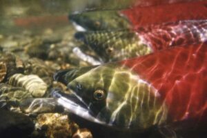 From its inception in 1983, the Yakama Nation Fisheries program of the Confederated Tribes and Bands of the Yakama Nation has employed scientific expertise in concert with traditional ecological knowledge to develop innovative projects and partnerships credited with restoring culturally important fish runs in the Columbia River. Learn more about how they’ve worked to restore important fish habitat and care for Washington watersheds.
Videos
The Ride! Old Milwaukee
A quick 2-minute video of what to expect on your ride!
Yakima River Canyon Formation
Not your average canyon. The Yakima River was there first and then the canyon walls around it lifted up!
Podcasts
Wind Turbines
Bike rides always give us a chance to meet interesting people, which is how we met David Anthes who knows a whole lot about wind turbines. Because so many of our bike routes go by wind turbines, we decided to find out more. David is a rope access technician on wind turbines all over the [...]
All About Basalt with the Rock Doctor
You will find these rocky columnar cliffs in Eastern and Central Oregon, but what exactly happened to form these unique structures? In this podcast, we talk with our resident rock doctor, Dr. Kim Ely.
Keep it Local! Learn More
Ridden and Reviewed by:

 Behind every route is scouting, mapping, storytelling, and a whole lot of pedal power.
Have you ridden this route? Got a question? Join the discussion!