Hillbilly Weather Station


Caution! We do not provide turn-by-turn directions in our GPX files. Those are auto-generated by your bike computer and are usually less than 70% accurate. Learn more.
For help loading a GPX file onto your bike computer, go here.
DownloadCredits & Acknowledgements
Course by Dirty Fingers Bike shop.
When We Like to Ride This
We really like this route early morning, mid-summer, when the skies are clear. Why? The flowers are in bloom, the views are big and the forested canopies give a nice cooling effect. However, the route goes almost all year. The exception is when there is snow in the hills. The maximum elevation on the route is 2500 feet.
Terrain & Riding
The ride starts on the Old Highway 8 trail, it is more of a paved hiking / biking trail than an actual road. You dodge rocks on the road turned to trail and then in a little over a mile, turn onto the section Old Highway 8 that can still handle cars. The rock formations are crazy fun … and the views of the Columbia River Gorge are outrageous.
At mile 2.7, on the right, you will see a small turn out which is the Catherine Creek trailhead. It’s well worth buzzing through the bike path (we didn’t see no bike signs) to get an even better view of Columbia. Oddly, while you are above the highway and the trains, you really don’t hear or see either.
After your diversion, continue up Old Highway 8, past vineyards. At the T at the end of stick of the lollipop, take a right and blast down to the river. Hop on the highway for a super short section (ick!) and then find the start of the Klickitat Trail (yeah!). This gravel path meanders next to the Klickitat River for 1.5 miles. Then you switchback (4) your way up Fisher Hill with views getting better and better as you climb. The grade is a consistent 4 to 6% for 1100 feet. After this, you continue to climb for another 1200 feet, but much more gradually and in a stair step fashion,.
When you turn inland from the switchbacks, the road straightens out and you start enjoying rolling farmlands and cattle country with some active forest logging areas thrown in. Fisher Hill road climbs for another 1200 feet, but over 6.5 miles.
At ~ mile 15 you come through a unique and beautiful section of Oregon White Oak. Several miles later the forest landscape transitions to pines such as the Jeffrey Pine, Long Needle Pine, Monterey Pine, Ponderosa Pine, Bill Pine and Gray Pine. We really enjoyed this section of route as it provided a cool respite from the summer sun.
Near the end of the 2300 ft climb, at ~ mile 20, the views start to open up and you start to catch the first bit of rollers … with the first bits of downhill thrown in. After the intermediate pavement section you may pick up a bit of washboard, but a clean line can be found.
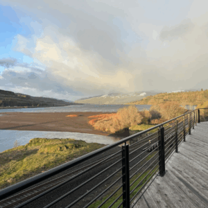
At mile 31, you roll through a heavily canopied forest section that is fast and fun. We like to call this the “Enchanted Forest.” After busting out of the forest, look for the Hillbilly Weather station on your left while climbing a small rise.
From here, you will soon be rolling downhill for over 2000 feet of loss, first on gravel and then pavement. Hit the stick of the lollipop, still cruising slightly downhill, and take in the big views of the Columbia River Gorge.
The Start
Coyote Wall parking area. At the intersection of Courtney road and Highway 14.
Food & Water
- None.
Route Notes
In our pictures you will see several people on mountain bikes. We believe in ‘ride what you have”. This route rides really well on a gravel / CX bike with tires 35 to 40 mm.
Also note, the picture sequence shows pictures from two different days. The first day we photographed the stick of the route, the second day, we photographed the loop of the route.
The route rides really good in both directions. Mitchell, from Dirty Fingers Bike shop, likes the route more in the opposite direction. He loves fast gravel descents with big views, which you get on Fisher Hill.
Route Options
The route can be shortened by starting at the trailhead of Klickitat trail just west of Lyle, Washington. There is a parking area with flush toilets. The route is then 35 miles with 3500 feet of gain. At mile 41.4 go left on Old Highway 8 (downhill) instead of right, to complete the loop.
Keep it Local! Learn More

 Behind every route is scouting, mapping, storytelling, and a whole lot of pedal power.
Have you ridden this route? Got a question? Join the discussion!