Concrete Highlands


Caution! We do not provide turn-by-turn directions in our GPX files. Those are auto-generated by your bike computer and are usually less than 70% accurate. Learn more.
For help loading a GPX file onto your bike computer, go here.
DownloadHighlights & Remarkable Spots
Concrete / Beginning & End of Ride
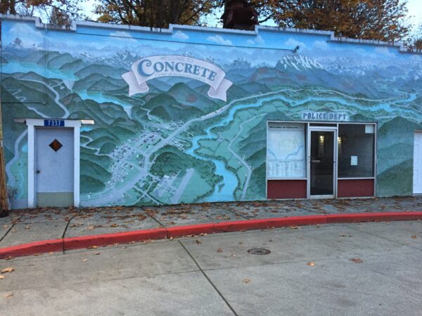
The town of Concrete has a rich history. The first settlement, known as “Minnehaha,” was created at the junction of the Baker and Skagit Rivers. In 1890, Magnus Miller laid out an official townsite, which led to the establishment of a post office and a name change to “Baker.” In 1905, a community sprung up around the Washington Portland Cement Company across the Baker River, giving rise to a new settlement called “Cement City.” When the Superior Portland Cement Company plant was constructed three years later in Baker, the towns merged, and the residents agreed on the name “Concrete.” [Concrete Chamber of Commerce]
Concrete Silo / Beginning & End of Ride
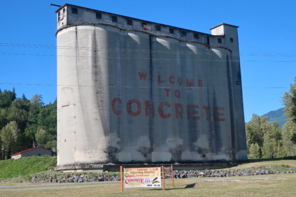
In the heydey of Concrete, the silos that tower above the town were a symbol of the area’s industry. Today the silos are a tomb of a bygone era. The town’s more recent claim to fame is that that a well-known writer, Tobias Wolff, once lived in Concrete. The words “Welcome to Concrete” were painted on the silos for the 1993 movie called “This Boy’s Life,” which is a movie based on Wolff’s memoir about living in the town in the 1950s. The movie stars Robert DeNiro, Ellen Barken, and the not-yet-famous Leonardo DiCaprio. [The Seattle Times]
Skagit River / ~ Miles 1-10 and 41-53
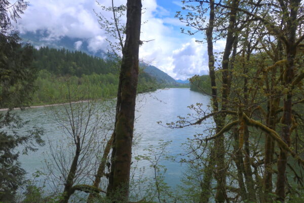
The Skagit River, designated by the US Congress in 1978 as a Wild and Scenic River, stretches 150 miles through British Columbia and Washington before it empties into the Puget Sound. With a watershed that covers 1.7 million acres in the Cascade Range, the Skagit River is the only large river system in the state that contains healthy populations of all five native salmon species – chinook, coho, chum, pink, and sockeye – and two species of trout: steelhead and coastal cutthroat. The Skagit River hosts one of the largest wintering bald eagle populations in the contiguous United States, attracting up to 800 eagles from inland Canada, Alaska, and Montana during abundant salmon runs. [Wikipedia]
Larsen Log / ~ Mile 6.0
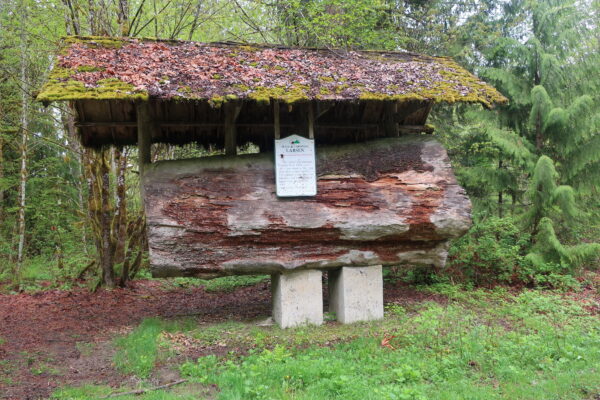
“This twelve foot diameter Douglas Fir is 1,303 years old. It was felled in 1972 and dedicated in their memory. The Larsens immigrated from Denmark and homesteaded below Sauk Mountain in 1887.” [Plaque on Larsen Log]
Cumberland Creek Conservation Area / ~ Mile 41.5
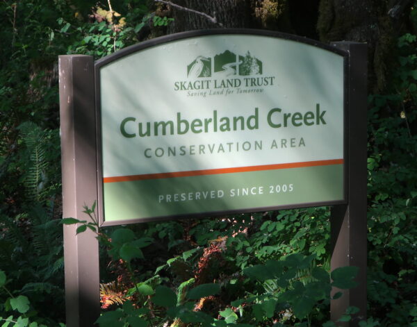
The interpretative trails of the Cumberland Creek Conversation Area showcase the diverse deciduous forests of the Skagit River floodplain, with cottonwoods, alders, and big-leaf maples providing homes for birds and amphibians. In an effort to restore over 4,000 feet of salmon habitat, in 2014 the creek was diverted back into its historic channel, which had been altered nearly 80 years prior when the South Skagit Highway was constructed. [Skagit Land Trust]
When We Like to Ride This
This route is rideable in summer and fall once the snow has melted out at higher elevations. The ride is best kept for a clear day when you will have optimal views of the surrounding mountains and river valley.
Terrain & Riding
THE TERRAIN
The first ten miles of the route traverses through agricultural fields and along the Skagit River.
For the next twenty-two miles, you will gradually climb along forest service roads. You’ll mostly be in the trees, riding alongside creeks and waterfalls, with sections of shade and sunshine.
As you near the summit, the views will open up. A half mile before the summit you will begin to see rocky peaks and logged mountainsides and then — bam — right in front of you will appear magnificent views of the Skagit River Valley, Mt Baker, and Sauk Mountain.
The remaining thirteen miles of the route take you along the Skagit River back to Concrete.
THE RIDING
Miles 0 to 10 are flat and paved. There is no shoulder, but the traffic is minimal.
Miles 10 through 32 climb more than 3,000 feet along narrow forest service roads. The climbing is all at a comfortable grade never exceeding 8%. The first six miles are paved, the next nine miles are intermittent pavement and gravel, and the remainder of the climb is exclusively on gravel. The roads are decent-ish. Since you are climbing, you’ll have plenty of time to weave your way between any rocks or dips that may appear in the road. At Mile 14, there will be a nice clearing for a snack break on the right side of the road. Just before Mile 22, there will be another spot for a snack on the left side of the road just before the bridge over Finney Creek. Early in the season, you may encounter tree debris.
Miles 32 through 41 will descend you back to the river valley. This is a consistently steep descent. Some sections are rough with big rocks and craters that can be difficult to see in the shade. Use caution when descending and be careful not to override your sight line. Beginning at Mile 37.5, you’ll want to stop your bike to take in the views of the valley below and the mountains across the way.
Miles 41 through 54 are similar to the first ten miles of the ride.
The Start
Silo Park in Concrete. Restrooms. No parking permit or fee required.
Food & Water
- None
Route Notes
The Upper Finney Creek Bridge (~ Mile 14.5) is closed to traffic due to construction for a seismic retrofit. The construction, which was scheduled to be completed 3/1/2023, has been delayed. Check out Skagit County’s Road Closure/Road Hazard Report for updates: https://www.skagitcounty.net/reporting/roadclose/.
Recommend riding the route in the direction as mapped, as this maximizes the views.
The light on the routes can vary from sunny to shady and all hues of filigreed light in-between. Wear bright colors and consider using bike lights. Keep your eyes open for potholes or other obstacles that may be obstructed by the shade.
Black bears reside in the forests along this route. Though the bears tend to be skittish, be bear-wise and consider carrying bear deterrent with you.
There are two campgrounds near Concrete. Howard Miller Steelhead Park, a local favorite, is ~7 miles to the east, and Rasar State Park is ~24 miles to the west.
If you encounter tree fall, please let us know by posting in the comments. From this, we can usually organize a work party and get it cleared.
Love Where You Ride! Learn More
In 2022, Puget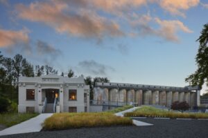 Sound Energy (PSE) opened a newly renovated visitors center in Concrete. The “Club House,” as the center is known, are repurposed industrial buildings from one of the town’s old cement factories and includes exhibits addressing the history of both the town as well as PSE. Consider cycling to the Club House, which is less than a mile from where the Concrete Highlands route begins. To reach the Club House, cycle east through downtown Concrete on Main Street and then cross the historical Henry Thompson Bridge over the Baker River.
Videos
Harnessing the Baker River
To keep up with a growing demand for power, Puget Sound Power and Light, a predecessor of today’s Puget Sound Energy, built a hydroelectric dam in the North Cascades. This 8-minute video discusses how the Baker River was harnessed for power and how the town of Concrete created the dam's key [...]
Conserving Cumberland Creek
This 4-minute video highlights the cultural and ecological importance of the Cumberland Creek Conservation Area.
Keep it Local! Learn More

Ridden and Reviewed by:

 Behind every route is scouting, mapping, storytelling, and a whole lot of pedal power.
Have you ridden this route? Got a question? Join the discussion!